
NOAA - Great Lakes Environmental Research Laboratory

|
Back to Met-ReCON Station Map Alpena | Chicago | Michigan City | Milwaukee | Muskegon | Muskegon Pier Light | South Haven | Thunder Bay Island | Toledo Light #2 Real-Time Meteorological Observation Network
See Metadata File for full description of instruments and parameters, as well as site maps.
See also rtmon status, webcam status
| ||||||||||||||||||||||||||||||||||||||||||||||||||||||||||||||||||||||||||||||||||||||||||||||||||||||||||||||||||||||||||||||||||||||||||||||||||||||||||||||||
|
Conditions at 12:32 pm EDT on 04/25/2024 (DOY 116 16:32 GMT)
(Updated every 30 minutes)
|
||||||||||||||||||||||||||||||||||||||||||||||||||||||||||||||||||||||||||||||||||||||||||||||||||||||||||||||||||||||||||||||||||||||||||||||||||||||||||||||||
|
||||||||||||||||||||||||||||||||||||||||||||||||||||||||||||||||||||||||||||||||||||||||||||||||||||||||||||||||||||||||||||||||||||||||||||||||||||||||||||||||
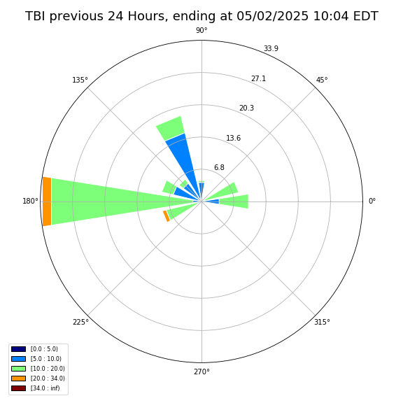
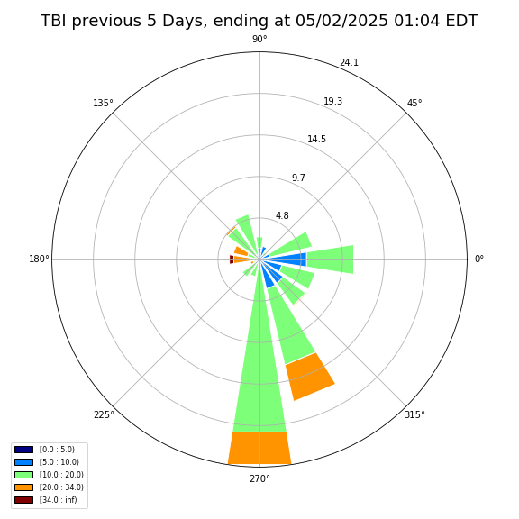
 Click here for recent 2-minute daily
data: 20240425.10t.txt.txt, data format (metadata) Click here for past data:
2024 | Archive Click here for recent 2-minute daily
data: 20240425.10t.txt.txt, data format (metadata) Click here for past data:
2024 | Archive
The NDBC station ID for this station is: TBIM4 Access current marine observations on your mobile device. See NDBC's mobile access page. These data are also available from NDBC website and NDBC's Dial-a-Buoy Program. See also NWS Marine Forecast for this area, and NWS Recreational Beach Forecast Realtime Data Disclaimer Special thanks to NWS, Thunder Bay National Marine Sanctuary (TBNMS), and 9th District USCG. Additional Great Lakes Meteorological Observations » NWS, Grand Rapids Office: Near-Realtime Marine Weather, includes current conditions and forecasts» NWS, White Lake Office: Near-Realtime Marine Weather, includes current conditions and forecasts » NDBC Great Lakes ImageMap showing U.S. and Canadian Buoys and C-MAN Stations » NOAA CoastWatch Great Lakes NOAAPORT Data, includes all station types » NOAA's NowCoast: Web mapping portal to real-time coastal observations » Winds courtesy of iWindsurf.com » NWS Great Lakes Marine Text Forecasts by Zone » Links to Great Lakes Water Temperature, Wind/Wave Data, & Water Levels » GLIN: Great Lakes Information Network | ||||||||||||||||||||||||||||||||||||||||||||||||||||||||||||||||||||||||||||||||||||||||||||||||||||||||||||||||||||||||||||||||||||||||||||||||||||||||||||||||
| Contact: | ||
|---|---|---|
| General Information & Media Inquiries: oar.glerl.www@noaa.gov (734) 741-2235 |
Data Inquiries: oar.glerl.data@noaa.gov |
|

![[Live Webcam Image from Thunder Bay Island, MI Met Station Camera 1]](tbi01.jpg?2404251603)
![[Live Webcam Image from Thunder Bay Island, MI Met Station Camera 2]](tbi02.jpg?2404251603)
![[Live Webcam Image from Thunder Bay Island, MI Met Station Camera 3]](tbi03.jpg?2404251603)
![[Live Webcam Image from Thunder Bay Island, MI Met Station Camera 4]](tbi04.jpg?2404251603)
![[Live Webcam Image from Thunder Bay Island, MI Met Station Camera 5]](tbi05.jpg?2404251603)