
NOAA - Great Lakes Environmental Research Laboratory

|
OSAT develops and uses remote sensing technology and products to record and observe the Great Lakes environment through the collection of data. Remote sensing technology enables observing, measuring, and monitoring of detailed and synoptic events on the earth’s surface (land and water) and atmosphere through the use of satellite-based, airborne, and ship-based sensors that are remote from the objects or events being observed. These observations directly benefit a wide range of research and operational constituents such as commercial shippers, modelers, recreational users, and regional drinking water managers.
Remote sensing systems function on either an active or passive level. Active sensors emit energy in the electro-magnetic spectrum and measure the energy reflected from the target. Radar is a widely used active sensor, sending and receiving microwaves (of various wavelength and polarization depending on the sensor) that can be used to determine the surface roughness, thickness, moisture content as well as position, direction of movement, or speed of objects. While active sensors are based on signal emission, passive sensors detect natural radiation that is emitted or reflected by the object or surrounding area. Reflected sunlight is the most common source of radiation measured by passive sensors, such as digital imaging systems. To make images meaningful in terms of desired observational information or geophysical product, analysis and interpretation are required.
|
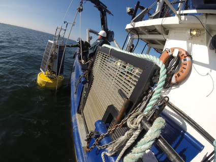
The overall intent of GLERL’s observing system work is to build a research and development base supporting coastal environmental observation networks, complementing NOAA’s ecosystem forecasting research goals. Observation platforms such as buoys and offshore structures should be designed with consideration of modern network compatible hardware and software. These systems must be capable of supporting real-time, high bandwidth, high resolution sensing systems (such as, passive and active fisheries acoustics transducers integrated with underwater video systems; underwater and surface autonomous systems; and standard physical, chemical and biological sensors) providing observations from surface to bottom. Greater environmental awareness can be achieved by deploying a data-gathering network capable of sensing on a variety of time frames and geographic scales. This information is then integrated into a mature data management and communications system that uses models and other tools to process data, and methods that deliver processed data and information to users. Systems currently in more mature stages of development, provide valuable real-time data used by regional stakeholders such as National Weather Service (NWS) marine forecasters, water intake managers, and recreational users.
The Great Lakes node of the operational NOAA CoastWatch program provides services and products including near real-time and historical satellite observations of algal blooms, plumes, ice cover, wind, lake surface temperatures, and two and three dimensional modeling of Great Lakes physical parameters (such as wave height and currents). In addition, through a cooperative project with Michigan Sea Grant, Great Lakes CoastWatch satellite-derived surface temperature imagery is contoured and made available via Michigan Sea Grant’s website. Great Lakes CoastWatch data and products benefit researchers as well as riparians, commercial and recreational users.
|
Located on Lake Michigan’s Muskegon Lake Channel, GLERL’s field station occupies three buildings and houses research staff, vessel crew, a marine superintendent, and administrative personnel.
The LMFS is strategically positioned on Lake Michigan to provide support to the local and regional community by further developing NOAA’s role in freshwater ecology, ecosystems management, coastal management, and water-based commerce. This field station promotes long-term observations, field work, and process studies essential for understanding and developing future ecological services. Additionally, the proximity of the field station to Lake Michigan provides a unique opportunity for engagement with tourists, recreational users, and members of the community.
The NOAA Great Lakes Environmental Research Laboratory (GLERL) Lake Michigan Field Station (LMFS) is home to vessel operations, which is a critical asset that supports NOAA GLERL science on the Great Lakes. The LMFS provides a base for vessel operations that support GLERL science branches by providing a safe and secure work environment in the conduct of scientific research. Additionally, vessel operations provide expertise to NOAA in small research vessel (SRV) operations. The mobility of GLERL vessels offers unique place-based opportunities for communications and education at Great Lakes Ports of Call.
OSAT’s mission for vessel operations is to provide support for field research and to develop new technology. To advance observational capacity in Great Lakes research, OSAT personnel develop scientific instrumentation and gear that ensures the effective operation of our scientific fleet of vessels. Vital to this effort is OSAT’s work in improving navigation, field communications, and data collection and storage on-board our vessels. The Green Ship Initiative—also conducted under OSAT’s vessel operations—uses advanced technology to convert research vessels from petroleum-based fuels and lubricants to renewable and environmentally-friendly products that reduce fossil fuel emissions.
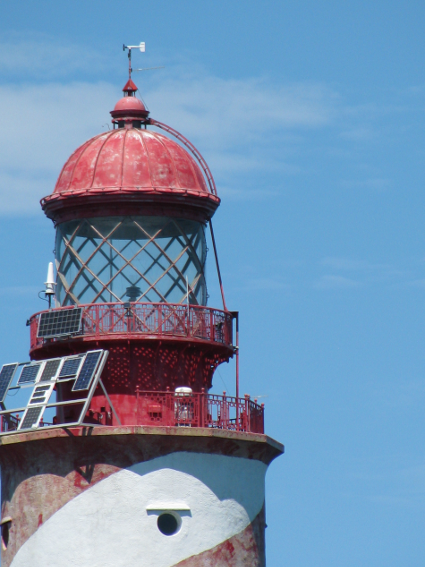
Meteorological observations are used in the Great Lakes Environmental Research Laboratory’s Great Lakes Coastal Forecasting System to improve nowcasts and forecasts of waves, water levels, water temperature, and circulation. Observations from these stations are also provided to the National Weather Service marine forecast offices at Milwaukee, Chicago, and Grand Rapids in real time and to the National Data Buoy Center for archiving and dissemination through the AWIPS and NOAAPORT systems. Fishers, boaters, surfers, and other recreational users find the real-time conditions and WebCam images useful in making plans for when and where to venture out on the water.
The need for development of regional coastal observing systems has been highlighted by the NOAA Strategic Plan, the National Ocean Partnership Program, and the Ocean Research Priorities Plan. Continual assessment of the status and trends in coastal environments permits identification of perturbations that may signal changes in the ecosystem, puts current trends into an historical framework, allows us to differentiate true environmental change from variance, and provides a context to assess the impact of predicted changes. The goal of the ReCON project is to develop a national network of low cost coastal buoys capable of seabed to sea-surface observations. The ReCON system has been designed from the beginning with a built-in capability to expand buoy observation sites to meet regional and national integrated observing system requirements.
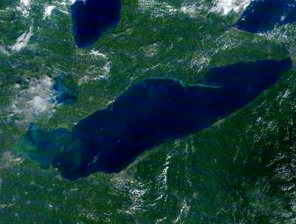
The Lake Erie ecosystem faces wide and varied threats to its health and integrity, including recurring low oxygen episodes ('dead zones') in the central basin. A prominent feature of Lake Erie's central basin is the lake bottom area of severe hypoxia ( < 2-3 ppm dissolved oxygen concentration) that recurs annually during late summer. Although the size of the dead zone declined with reduced phosphorus inputs during the mid-1980s, current levels of oxygen depletion are on par with those observed during the preceding period of severe cultural eutrophication, which is of concern to both Lake Erie resource management agencies and user groups.
The Hypoxia Warning System is intended to combine observed data and forecasted surface
currents to provide Lake Erie central basin drinking water managers information about the transport of hypoxic water into water intakes. The objectives of the project are to understand the chemistry and biology surrounding the microbial-driven formation of hypoxia and subsequently provide warnings of water chemistry changes, upwelling events and internal waves impacting drinking water quality at Cleveland, OH.
Additional information:
Experimental Hypoxia Warning System (Fact sheet)
CoastWatch is a nationwide National Oceanic and Atmospheric (NOAA) program within which GLERL functions as the Great Lakes regional node. In this capacity, GLERL obtains, produces, and delivers environmental data and products for near real-time observation of the Great Lakes to support environmental science, decision making, and supporting research. This is achieved by providing access to near real-time and retrospective satellite observations and in-situ Great Lakes data. The goals and objectives of the CoastWatch Great Lakes Program directly support NOAA's statutory responsibilities in estuarine and marine science living marine resource protection, and ecosystem monitoring and management.
