Computerized Bathymetry and Shorelines of the Great Lakes

NOAA Data Report ERL GLERL-16
David J. Schwab
Diana L. Sellers
Great Lakes Environmental Research Laboratory
Ann Arbor, Michigan
March 1980
Revised January 1996
GLERL Contribution No. 212
Contents
Abstract
1. Introduction
2. Bathymetric Data
3. Shoreline Data
4. Geographical Conversions
5. Procedure For Obtaining Data
6. Acknowledgments
7. References
Appendix. Data Base Format
This report describes bathymetric grid data and digitized shorelines compiled for the five
Great Lakes and Lake St. Clair. The bathymetric grids consist of an array containing the average
lake depths in 2-km squares (1.2-km squares for Lake St. Clair). The digitized shorelines
are lists of latitudes and longitudes for closed loops describing lake and island shorelines.
Conversion equations for map-to-geographical and geographical-to-map coordinate transformations
are given for all the bathymetric grids. An appendix details the format of the data
base.
1. INTRODUCTION
The increasing use of the computer to tabulate field data, to run numerical models, and to
display data graphically requires a computer-compatible data base containing Great Lakes
depths and shorelines. To this end, Hughes et al. (1972) compiled depth and shoreline
data for Lakes Michigan and Ontario on a 2-min grid. Subsequently, Robertson and Jordan (unpublished)
made available average depths in 2-km squares for Lakes Ontario, Erie, Huron, and
Superior. This data set did not include shoreline digitizations. Both of these data bases used
depths averaged from U.S. Army Corps of Engineers
and Canadian Hydrographic Service
1:60,000-1:120,00 scale charts. In the near future the individual soundings used to compile
the bathymetric charts will be available from the National
Ocean Survey in computer compatible
format, but for most applications the most convenient form for bathymetric data is on a
regular grid and for shoreline data as closed shoreline curves. The purpose of this report is to
consolidate the Lake Michigan work of Hughes et al. with the Robertson and Jordan data base,
to add Lake St. Clair bathymetric data, and to include shoreline digitizations for all the lakes in
a single, well-documented, computer compatible depth and shoreline data base. The largest
part of the work is manually averaging depth data on 2-min and 2-km grids. Most of this
tedious work has been carried out in the aforementioned reports and due credit is given to
the individuals responsible. The additional work of interpolating the 2-min to a 2-km grid for
Lake Michigan, compiling a high resolution Lake St. Clair depth grid, digitizing the lake and
island shorelines, and formulating map-to-geographic coordinate conversions and their inverses
for these grids was accomplished at the Great Lakes Environmental Research Laboratory (GLERL).
2. BATHYMETRIC DATA
Bathymetric data for Lakes Ontario, Erie, Huron, and Superior on a 2-km grid as described in
Robertson and Jordan (unpublished) was obtained from the Canada Center for Inland Waters.
They superimposed 2-km grids on standard bathymetric charts and averaged a mean depth in
each grid square by eye. Depths are relative to the Great Lakes Datum of 1955 (Dohler,
1961). All grids are aligned with the central meridian of the bathymetric chart, except that
for Lake Erie, which is tilted 27.33° counterclockwise to obtain a better fit to the shoreline.
GLERL carried out a similar procedure for Lake St. Clair with a 1.2-km grid rotated 2.24°
clockwise from a central meridian of 82.67°. National Ocean Survey chart number 14850 was
used for Lake St. Clair depths. The chart scale is 1:60,000. For Lake Michigan, a 2-km grid
aligned with the 86.50° meridian was defined. A computer subroutine was written to interpolate
the 2-min grid depths of Hughes et al. to arbitrary latitude and longitude by bilinear
interpolation within each 2-min square. These data were used to calculate the average depth
in each 2-km grid square by averaging the depth at the center of the square and the four
depths at coordinates (.5,.5), (.5,-.5), (-.5,-.5), and (-.5,.5) km relative to the center of the
square. Depths at some grid squares near the shoreline were adjusted by hand so that they
better fit the actual lake shoreline. The data for Lake Michigan were then put into the same
format as those for the rest of the lakes. Statistics for the digitized bathymetric data of the
Great Lakes are presented in Table 1.
                         Table l. Statistics for Bathymetric Data


________________________________________________________________________________________

           Grid    East-West North-South  Central  Reference  Surface area   Volume
  Lake   size (km)   grids      grids    Meridian  datum (m)  (10**9 m**2) (10**12 m**3)
________________________________________________________________________________________

Superior      2       304        147       88.00°    182.88      82.2        11.82

Michigan      2       160        250       86.50°    175.81      59.9         4.79

Huron         2       209        188       82.75°    175.81      59.6         3.40

St. Clair*  1.2        35         36       82.67°    174.25       1.1         0.0039

Erie+         2       209         57       81.00°    173.31      25.3         0.47

Ontario       2       152         57       78.00°     74.01      18.5         1.67
________________________________________________________________________________________

    * The Lake St. Clair bathymetric grid is rotated 2.24° clockwise.

    + The Lake Erie bathymetric grid is rotated 27.33° counterclockwise.
3. SHORELINE DATA
The shorelines of the Great Lakes and many of the islands were digitized from
National Ocean
Survey 1:400,000 charts for Lakes Ontario (chart number 14800), Erie (chart number
14820), St. Clair (chart number 14820); 1:500,000 charts for Lakes Huron (chart number
14860) and Michigan (chart number 14900); and the 1:600,000 chart for Lake Superior
(chart number 14960) on a digitizing table. The average segment length was 1.24 km. The
geographical coordinates of the endpoints of each segment were then ordered so that each
lake shoreline and each island formed a closed loop. The Straits of Mackinac were closed to
separate Lakes Michigan and Huron. Statistics for the digitized shorelines of the lakes are
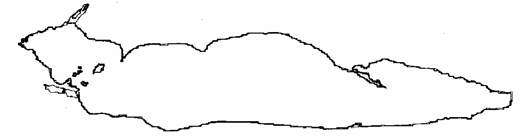
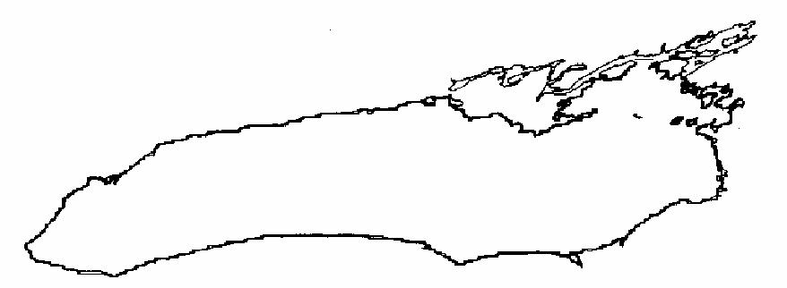
given in table 2. The digitized shoreline for each lake is superimposed on the outline of the
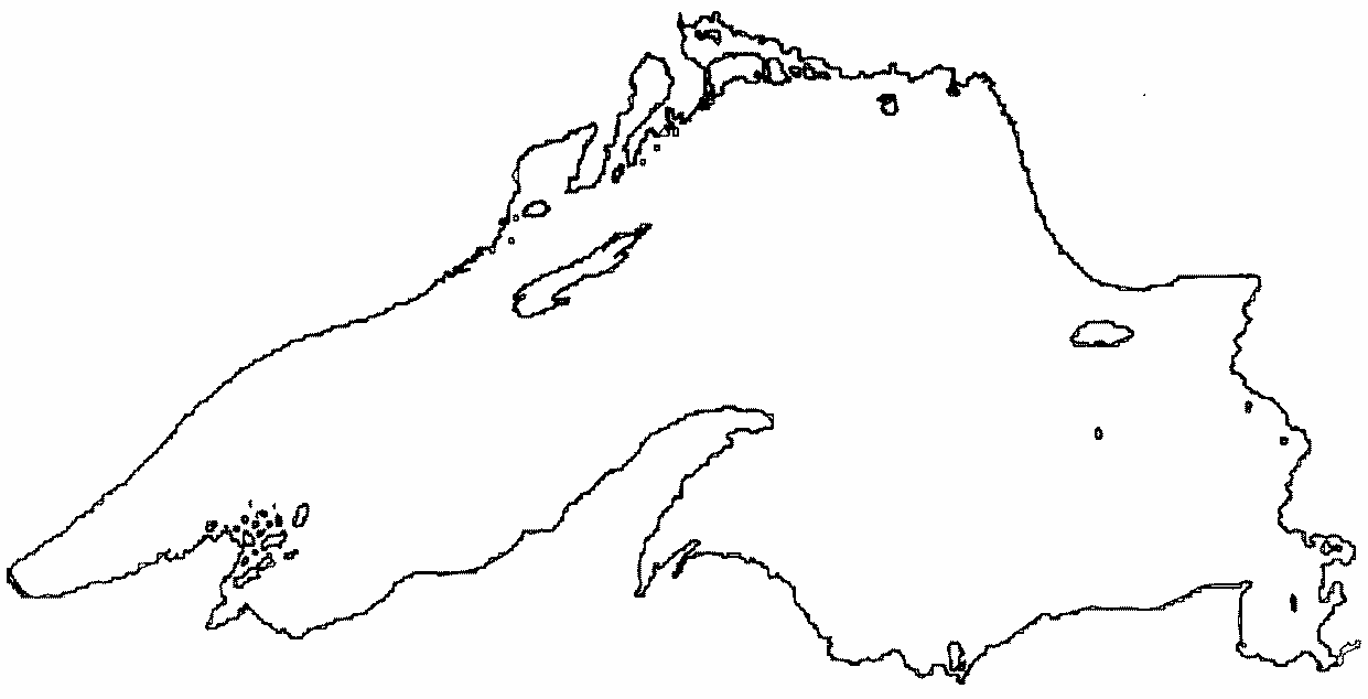
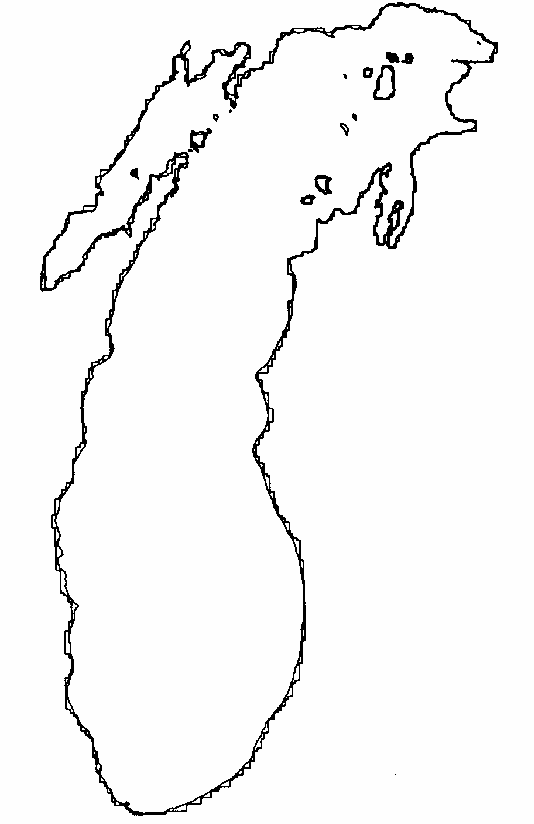
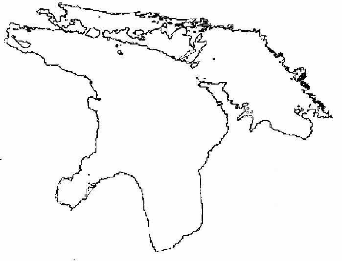
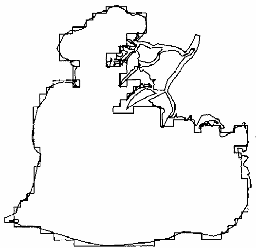
bathymetric grid in figures 1-6.
                        Table 2. Statistics for Shoreline Data


__________________________________________________________________________________

                   Number of segments  Shore length (10**6 m)  Area (10**9 m**2)
        Number of  __________________  ______________________  _________________
  Lake   islands     lake   islands       lake      islands     lake    islands
__________________________________________________________________________________

Superior    41       1387      741        2.62        1.04      84.0       1.58
Michigan    21       1537      443        2.15        0.35      57.9       0.39
Huron       66       2473     1672        2.94        1.65      63.4       3.96
St. Clair   15        182      262        0.19        0.16       1.2       0.07
Erie         7        888      167        1.32        0.13      25.8       0.10
Ontario     16       1434      468        1.50        0.35      19.6       0.33
__________________________________________________________________________________
4. GEOGRAPHICAL CONVERSIONS
The bathymetric grids described above are based on charts with polyconic projections. To
convert geographic coordinates (latitude and longitude) to grid coordinates (x and y) and
vice-versa, one could use the exact polyconic projection formulas for the original charts, but
these formulas are complicated and time-consuming to calculate even by computer. Conversion
formulas with sufficient accuracy for most purposes (approximately 500 m) can be
obtained by a simple expansion of the geographical coordinate in terms of the grid coordinate
and vice-versa.
The formulas for the geographical-to-map coordinate transformation are
       x = a Dlon + b Dlat + c Dlon Dlat + d Dlon**2 and

       y = e Dlon + f Dlat + g Dlon Dlat + h Dlon**2
where x and y are the eastward and northward grid distances in kilometers from the base
latitude and longitude of the grid, Dlat is latitude minus base latitude, Dlon is base
longitude minus longitude, and a...h are the transformation coefficients. These values
were determined for the Lakes Ontario, Erie, Huron, and Superior bathymetric grids by
Rodgers (1969). A similar procedure was used at GLERL to determine the coefficients for
Lakes St. Clair and Michigan. For grids oriented parallel to the central meridian, coefficients
d and g are not used. This is equivalent to assuming a linear variation of x with longitude and
a quadratic variation of y with longitude for a fixed latitude in these cases. The transformation
coefficients a...h and base longitude and latitude for each bathymetric grid are given in table 3.
These transformations were used to plot the shoreline digitizations on the bathymetric grid in
figures 1-6.
Figure 1.
Outline of digitized bathymetric grid and digitized shoreline for Lake Superior.
Figure 2.
Outline of digitized bathymetric grid and digitized shoreline for Lake Michigan.
Figure 3.
Outline of digitized bathymetric grid and digitized shoreline for Lake Huron.
Figure 4.
Outline of digitized bathymetric grid and digitized shoreline for Lake St. Clair.
Figure 5.
Outline of digitized bathymetric grid and digitized shoreline for Lake Erie.
Figure 6.
Outline of digitized bathymetric grid and digitized shoreline for Lake Ontario.
        Table 3. Geographical-to-map coordinate transformation coefficients. The
                 equations are x = a Dlon + b Dlat + c Dlon Dlat + d Dlon**2 and
                 y = e Dlon + f Dlat + g DlonDlat + h Dlon**2.  Dlat is latitude
                 minus base latitude. Dlon is base longitude minus longitude. x
                 and y are in km.


________________________________________________________________________________________________

            Grid      Base longitude,    a              b             c              d
  Lake   orientation   base latitude        e              f             g              h
________________________________________________________________________________________________

Superior     0°       92.10275°W      7.70215E+1     5.84617E+0    -1.42494E+0     ----------

                        46.31846°N      -3.98892E+0    1.11176E+2     ----------      4.86127E-1

Michigan     0°       87.94260°W      8.31831E+1     1.90171E+0    -1.31825E+0     ----------

                        41.60766°N      -2.07627E+0    1.11000E+2     ----------      9.58685E-1

Huron        0°       84.6620°W       8.15869E+1     2.57588E+0    -1.34705E+0     ----------

                        42.96603°N      -1.85606E+0    1.11111E+2     ----------      4.85354E-1

St.Clair  2.24°cw*    82.93158°W      8.22690E+1    -4.18687E+0    -8.92958E-1     5.49244E-1

                        42.30415°N       2.84351E+0    1.10232E+2     1.82918E-1      2.35336E-1

Erie     27.33°ccw+   82.98345°W      7.40161E+1     5.29979E+1    -1.15249E+0     2.21791E-1

                        40.97000°N      -4.01422E+1    9.76373E+1     5.95700E-1      4.29100E-1

Ontario      0°       79.81996°W      8.13204E+1     2.42939E+0    -1.33486E+0     ----------

                        43.16554°N      -1.76688E+0    1.11101E+2     ----------      4.85416E-1

________________________________________________________________________________________________


   * Clockwise
   + Counterclockwise
The formulas for map-to-geographic coordinate transformation are
       Dlon = Ax + By + Cxy + Dx**2   and

       Dlat = Ex + Fy + Gxy + Hx**2,
where A...H are the map-to-geographic transformation coefficients. For each lake a series of
64 sets of geographic coordinate pairs covering the lake were converted to x and y values by
the formulas given above. These sets of x, y, Dlat, and Dlon values were then used to determine
A...H by least-squares fitting to the map-to-geographic coordinate transformation equations.
Again, for grids parallel to the central meridian D and G were not used. The results of
the least-squares procedure for A...H and the maximum errors for each lake are given in Table 4.
______________________________________________________________________________________

        Table 4. Map-to-geographical coordinate transformation coefficients.
                 The equations are Dlon = Ax + By + Cxy + DX**2 and
                 Dlat = Ex + Fy + Gxy + Hx**2. Dlat is latitude minus base
                 latitude. Dlon is base longitude minus longitude. x and y
                 are in km.
______________________________________________________________________________________

              A            B            C            D       Max. longitude deviation
  Lake           E            F            G            H      Max. latitude deviation
______________________________________________________________________________________

Superior    1.29841E-2   -7.17624E-4   2.26882E-6   ----------    9.63680E-4

              4.77160E-4    8.98120E-3   ----------   -7.57848E-7   9.56804E-4

Michigan    1.20166E-2   -2.19428E-4   1.83917E-6   ----------    9.52070E-4

              2.41793E-4    9.00600E-3   ----------   -1.33547E-6   9.50140E-4

Huron       1.22482E-2   -2.97178E-4   1.92849E-6   ----------    9.99598E-4

              2.20311E-4    8.99372E-3   ----------   -7.02891E-7   9.79506E-4

St.Clair    1.21387E-2    4.62637E-3   1.10856E-6   -1.02938E-6   9.59513E-5

             -3.13049E-4    9.05963E-3   -2.3882E-7   -2.79918E-7   9.46533E-5

Erie        1.03968E-2   -5.80515E-3   1.52086E-6    7.78340E-7   9.53751E-4

            4.28786E-3    7.888811E-3   6.05812E-7  -4.81076E-7   9.53751E-4

Ontario     1.22965E-2   -2.74739E-4   1.85864E-6   ----------    8.78075E-5

              1.99237E-4    8.99770E-3   ----------   -6.74272E-7   8.78075E-5
______________________________________________________________________________________
5. PROCEDURE FOR OBTAINING DATA
The Great Lakes shoreline and bathymetric data base is available
from the GLERL website.
Bathymetry is also available through the National Geophysical and Solar-Terrestrial Data Center's
Bathymetric, Hydrographic, and
Relief Data Web page.
National Geophysical and Solar-Terrestrial Data Center
NOAA/EDIS/NASDC
Mail Code: D-621
Boulder, CO 80303
303-499-1000 ext. 6376 or 6338
6. ACKNOWLEDGMENTS
We would like to thank Don Robertson, Dianne Jordan-Kaiser, and their co-workers at the
Canada Centre for Inland Waters for allowing
us to use their bathymetric grids for Lakes
Ontario, Erie, Huron, and Superior. The Lake Michigan 2-min bathymetric data were compiled
at Argonne National Laboratory by Tom Hughes and co-workers.
At GLERL, John Mather
sorted out the Great Lakes shoreline digitization data and Don Dossett compiled the Lake St.
Clair bathymetric grid.
7. REFERENCES
- Dohler, G. C. (1961): The adoption of the International Great Lakes Datum, 1955, Canadian
Hydrographic Service, Surveys and Mapping Branch, Department of Mines and Technical Surveys,
Ottawa, Ont. 28 pp.
- Hughes, T. H., G. E. Birchfield, and M. T. Matthies (1972): A compilation of the average depths
of Lake Michigan and Lake Ontario on a 2-min grid, Report ANL/ES-10, Argonne National Laboratory,
Argonne, Ill. 94 pp.
- Robertson, D. G., and D. E. Jordan (unpublished): Digital bathymetry of Lakes Ontario, Erie,
Huron, Superior, and Georgian Bay, Canada Centre for Inland Waters unpublished report,
Canada Centre for Inland Waters, Burlington, Ont. 10 pp.
- Rodgers, G. K. (1969): Data atlas project, Project Report No. HO 83836, Great Lakes
Institute, University of Toronto, Toronto, Ont. 21 pp.
Appendix -- DATA BASE FORMAT
The bathymetric and shoreline data base consists of 80-character card image records. For
each lake the following records are included:
1. bathymetric data header records
2. bathymetric data records
3. lake shoreline header record
4. lake shoreline data records
5. island shoreline header records
6. island shoreline data records
For each lake there are six bathymetric data header records and one shoreline header record.
The format of each record type and the card columns used are as follows:
                                             FORTRAN         Card
                                              format        columns

1.1 Bathymetric data header record 1:

     lake name                                 50A1           1-50
     blank                                      30X          51-80

1.2 Bathymetric data header record 2:

     number of east-west grid boxes              I5           1-5
     number of north-south grid boxes            I5           6-10
     base latitude                            F12.7          11-22
     base longitude                           F12.7          23-34
     grid size (m)                               I5          35-39
     maximum depth (m)                           I5          40-44
     blank                                      36X          45-80

1.3 Bathymetric data header record 3:
    geographic-to-map coordinate conversion
    coefficients for x.

     a                                        E15.6           1-15
     b                                        E15.6          16-30
     c                                        E15.6          31-45
     d                                        E15.6          46-60
     BLANK                                      20X          61-80

1.4 Bathymetric data header record 4:
    geographic-to-map coordinate conversion
    coefficients for y.

     e                                        E15.6           1-15
     f                                        E15.6          16-30
     g                                        E15.6          31-45
     h                                        E15.6          46-60
     BLANK                                      20X          61-80

1.5 Bathymetric data header record 5:
    map-to-geographic coordinate conversion
    coefficients for longitude.

     a                                        E15.6           1-15
     b                                        E15.6          16-30
     c                                        E15.6          31-45
     d                                        E15.6          46-60
     BLANK                                      20X          61-80

1.6 Bathymetric data header record 6:
    map-to-geographic coordinate conversion
    coefficients for latitude.

     e                                        E15.6           1-15
     f                                        E15.6          16-30
     g                                        E15.6          31-45
     h                                        E15.6          46-60
     BLANK                                      20X          61-80

2. Bathymetric data records:

     depths in meters                          19I4           1-76
     sequence number                             I4          77-80

3. Lake shoreline header record:

     blank                                      20X           1-20
     lake name                                 60A1          21-80

4. Lake shoreline data:

     longitude, latitude pairs             4(2F9.5)           1-72
     sequence number                             I8          73-80

5. Island shoreline header record:

     blank                                       20           1-20
     island name                               60A1          21-80

6. Island shoreline data:

     longitude-latitude pairs              4(2f9.5)           1-72
     sequence number                             I8          73-80
NOTES:
- The depths on bathymetric data cards fill the bathymetric grid proceeding west to east and
then south to north. The following FORTRAN statements could be used to read the bathymetric
data cards:
           READ 10, (NDEPTH(I,J), I = 1, IMAX), J = 1, JMAX)
        10 FORMAT (19I4,4X)
where IMAX is the number of east-west grids and JMAX is the number of north-south grids as
given in table 1. Zero depth indicates land.
- The first and last longitude-latitude pair of each lake shoreline or island shoreline are the
same. If the last longitude- latitude pair is not the last pair in a record, the remaining pairs are
set to zero. If it is the last pair in a record, the next record will consist of eight zeros.
The number of other records for each lake is given in Table 5. The total number of records is 10,949.
______________________________________________________________________________

              Table 5. The number of bathymetric data and shoreline
                       record in the data base for each lake.

------------------------------------------------------------------------------

                             Superior  Michigan  Huron  St.Clair  Erie Ontario

Bathymetric data records        2352     2106     2068     67      627   456

Lake shoreline data records      348      385      619     46      223   359

Island shoreline header records   41       21       66     15        7    16

Island shoreline data records    221      129      478     78       48   131

______________________________________________________________________________
URL: https://www.glerl.noaa.gov/pubs/tech_reports/glerl-016/dr-016.html/