NOAA Great Lakes Environmental Research Laboratory Blog

The latest news and information about NOAA research in and around the Great Lakes

July 31, 2017
by Katherine Glassner-Shwayder
Comments Off on GLERL receives two RTAP awards for transitioning HABs and ice forecast model to operations

GLERL receives two RTAP awards for transitioning HABs and ice forecast model to operations

GLERL’s Dr. Eric Anderson has recently been awarded funding from the Research Transition Acceleration Program (RTAP), placing two of GLERL’s FVCOM modeling projects on the fast track to transition from research to operations (R2O).  R2O is the pathway by which … Continue reading

June 28, 2017
by Katherine Glassner-Shwayder
Comments Off on A message from the Director: Integrating science-based adaptive management into GLERL research

A message from the Director: Integrating science-based adaptive management into GLERL research

One thing that can be said with certainty about the Great Lakes ecosystem, is that it is in a constant state of change. The primary question for NOAA’s Great Lakes Environmental Research Laboratory (GLERL) is, how can we most effectively … Continue reading

June 28, 2017
by Katherine Glassner-Shwayder
4 Comments

Update on Lake Erie hypoxia forecasting stakeholder workshop (May 23, 2017)

Researchers partner with drinking water plant managers to forecast hypoxia in Lake Erie By Devin Gill, Cooperative Institute for Great Lakes Research and Kristin Schrader, Great Lakes Observation Systems Lake Erie’s “dead zone” not only impacts the lake’s ecosystem, but … Continue reading

May 30, 2017
by Katherine Glassner-Shwayder
Comments Off on NOAA GLERL staff participate in community education events

NOAA GLERL staff participate in community education events

Two opportunities to highlight NOAA’s mission of Science, Service and Stewardship NOAA’s Great Lakes Environmental Research Laboratory (GLERL) remote sensing scientist, Dr. George Leshkevich, and Information Services team member, Katherine Glassner-Shwayder, participated in Washtenaw Community College’s (WCC) Earth Day Month Celebration … Continue reading

May 30, 2017
by Margaret Lansing
Comments Off on NOAA GLERL collaborating with partners to monitor the Lake Huron ecosystem

NOAA GLERL collaborating with partners to monitor the Lake Huron ecosystem

The NOAA Great Lakes Environmental Research Laboratory (GLERL) is participating in an international, multi-agency effort to study invasive species, water quality, fisheries, and climate change in Lake Huron this field season—pursuing key knowledge gaps in the ecosystem. The Coordinated Science … Continue reading

May 10, 2017
by Nicole Rice
Comments Off on “Just Because the Blooms in Lake Erie Slow Down, Doesn’t Mean We Do”

“Just Because the Blooms in Lake Erie Slow Down, Doesn’t Mean We Do”

NOAA GLERL harmful algal blooms research program featured on Detroit Public Television As part of a series on The Blue Economy of the Great Lakes, NOAA’s Great Lakes Environmental Research Laboratory (GLERL) is featured in a short video, produced by … Continue reading

May 4, 2017
by Nicole Rice
Comments Off on NOAA research to be highlighted at bi-national Conference on Great Lakes Research

NOAA research to be highlighted at bi-national Conference on Great Lakes Research

Researchers from NOAA GLERL and the Cooperative Institute for Great Lakes Research (CIGLR), know formerly as CILER, along with other collaborators, will showcase their work on observations, advanced technologies, harmful algal blooms, modeling, forecasting, and more at the 60th Conference on … Continue reading

Aerial photo survey improves NOAA GLERL’s Lake Erie ice model

April 12, 2017 by Kaye LaFond

Understanding the duration, extent, and movement of Great Lakes ice is important for the Great Lakes maritime industry, public safety, and the recreational economy. Lake Erie is ice-prone, with maximum cover surpassing 80% many winters.

Multiple times a day throughout winter, GLERL’s 3D ice model predicts ice thickness and concentration on the surface of Lake Erie. The output is available to the public, but the model is under development, meaning that modelers still have research to do to get it to better reflect reality.

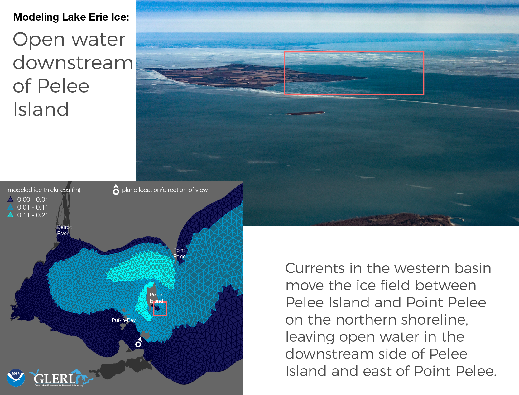
As our scientists make adjustments to the model, they need to compare its output with actual conditions so they know that it’s getting more accurate. So, on January 13th of this year, they sent a plane with a photographer to fly the edge of the lake and take photos of the ice.

The map below shows the ice model output for that day, along with the plane’s flight path and the location of the 172 aerial photos that were captured.

NOAA GLERL Lake Erie ice model output with all aerial photo survey locations -- January 13, 2017. Credit NOAA GLERL/Kaye LaFond.

NOAA GLERL Lake Erie ice model output with all aerial photo survey locations — January 13, 2017. Map Credit NOAA GLERL/Kaye LaFond.

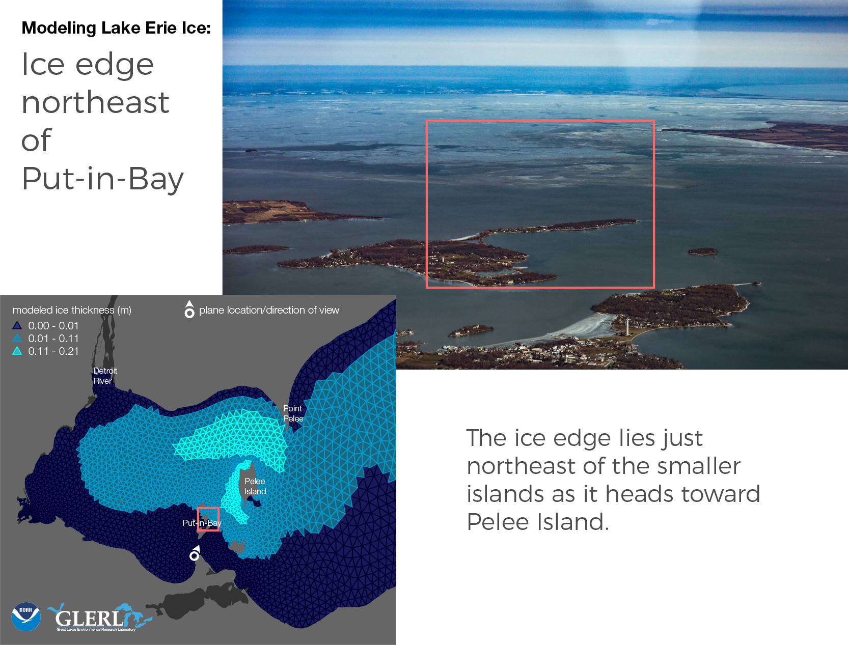
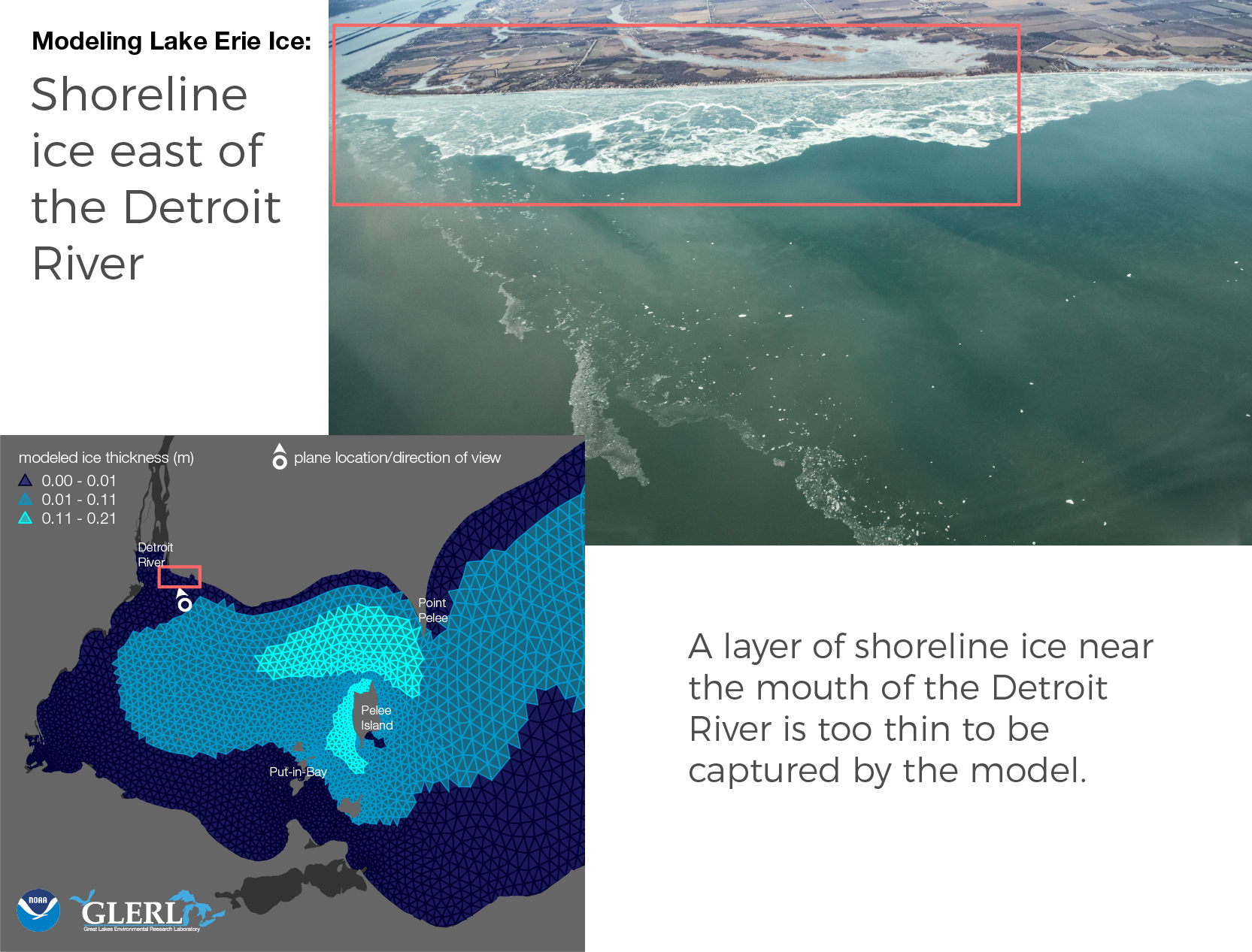
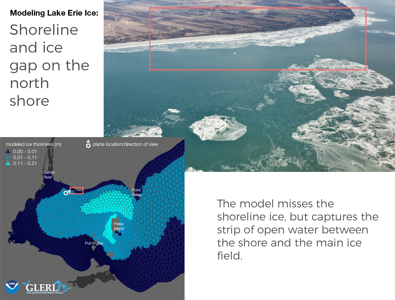
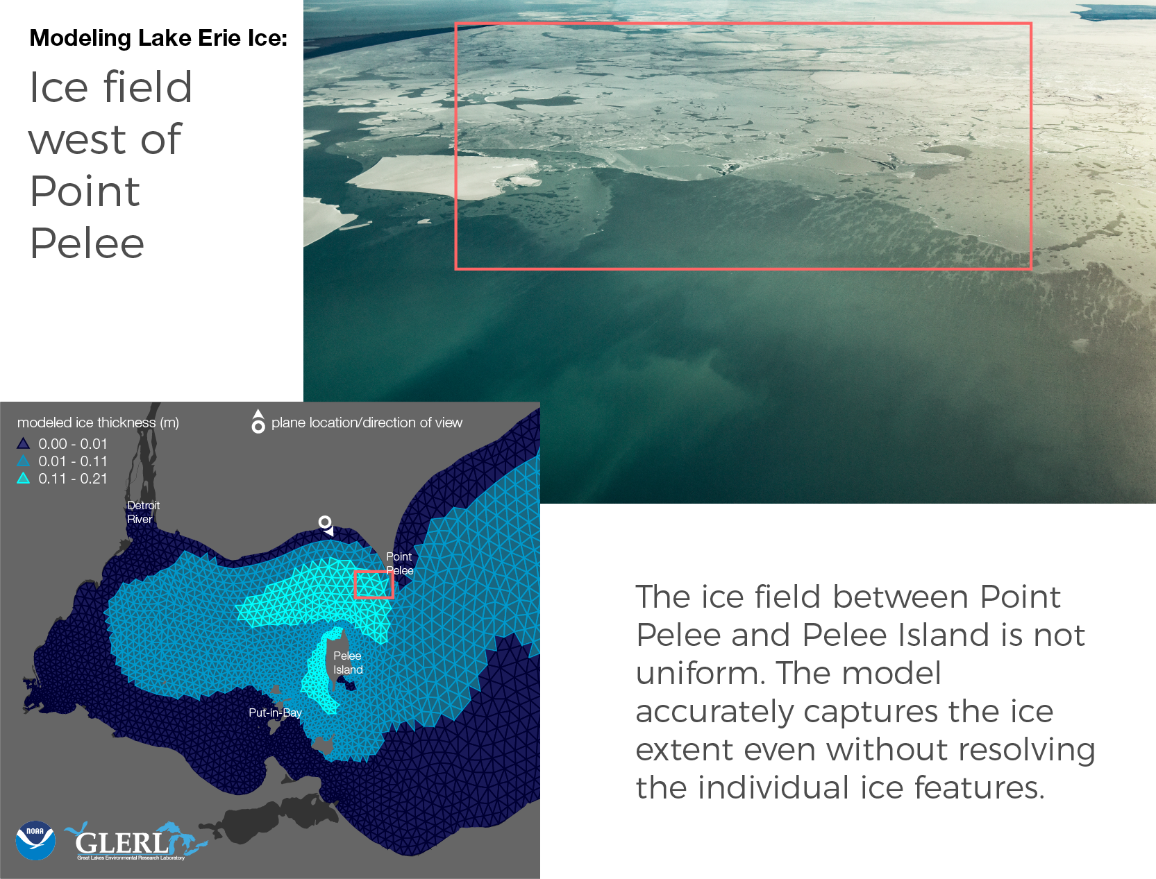
These photos provide a detailed look at the sometimes complex ice formations on the lake, and let our scientists know if there are places where the model is falling short.

Often, the model output can also be compared to images and surface temperature measurements taken from satellites. That information goes into the GLSEA product on our website (this is separate from the ice model). GLSEA is useful to check the ice model with. However, it’s important to get this extra information.

“These photographs not only enable us to visualize the ice field when satellite data is not available, but also allow us to recognize the spatial scale or limit below which the model has difficulty in simulating the ice structures.” says Eric Anderson, an oceanographer at GLERL and one of the modelers.

 “This is particularly evident near the Canadian coastline just east of the Detroit River mouth, where shoreline ice and detached ice floes just beyond the shoreline are not captured by the model. These floes are not only often at a smaller spatial scale than the model grid, but also the fine scale mechanical processes that affect ice concentration and thickness in this region are not accurately represented by the model physics.”

Click through the images below to see how select photos compared to the model output. To see all 172 photos, check out our album on Flickr. The photos were taken by Zachary Haslick of Aerial Associates.


This gallery contains 0 photos
March 24, 2017
by Katherine Glassner-Shwayder
2 Comments

Lake Erie Hypoxia Forecasting Project Kicks Off With Stakeholder Workshop

A collaborative research team, led by Drs. Craig Stow of the National Oceanic and Atmospheric Administration’s Great Lakes Environmental Research Laboratory (NOAA GLERL) and Mark Rowe of the University of Michigan’s Cooperative Institute for Limnology and Ecosystems Research (CILER),  will … Continue reading

March 24, 2017
by Katherine Glassner-Shwayder
Comments Off on Arrival of wave GLIDER SV2 platforms to expand GLERL data collection capacity in the Great Lakes

Arrival of wave GLIDER SV2 platforms to expand GLERL data collection capacity in the Great Lakes

Left and bottom right: OSAT staff learning the ropes on the Wave GLIDER SV2 during a three-day training in Kawaihae, Hawaii. Top right: CILER’s Russ Miller (left) and GLERL’s Kyle Beadle (right) work in GLERL’s laboratory to prepare the newly … Continue reading