
NOAA - Great Lakes Environmental Research Laboratory

Featured Tools
Great Lakes water levels are continuously monitored by U.S. and Canadian federal agencies in the region through a binational partnership. NOAA-GLERL relies on this water level data to conduct research on components of the regional water budget and to improve predictive models. Water level monitoring stations are operated by NOAA's Center for Operational Oceanographic Products and Services (CO-OPS) and the Department of Fisheries and Oceans' Canadian Hydrographic Service. The U.S. Army Corps of Engineers (Detroit, Chicago, Buffalo) and Environment and Climate Change Canada play crucial roles in research, coordination of data and operational seasonal water level forecasts for the basin.
For more information on particular aspects of Great Lakes Water Levels, use the tabs above:
Great Lakes water levels data constitute one of the longest high quality hydrometeorological data sets in North America with United States' reference gauge records beginning in 1860. Monitoring Great Lakes water levels is an important part of NOAA's mission to understand and predict changes in climate, weather, oceans, and coasts.
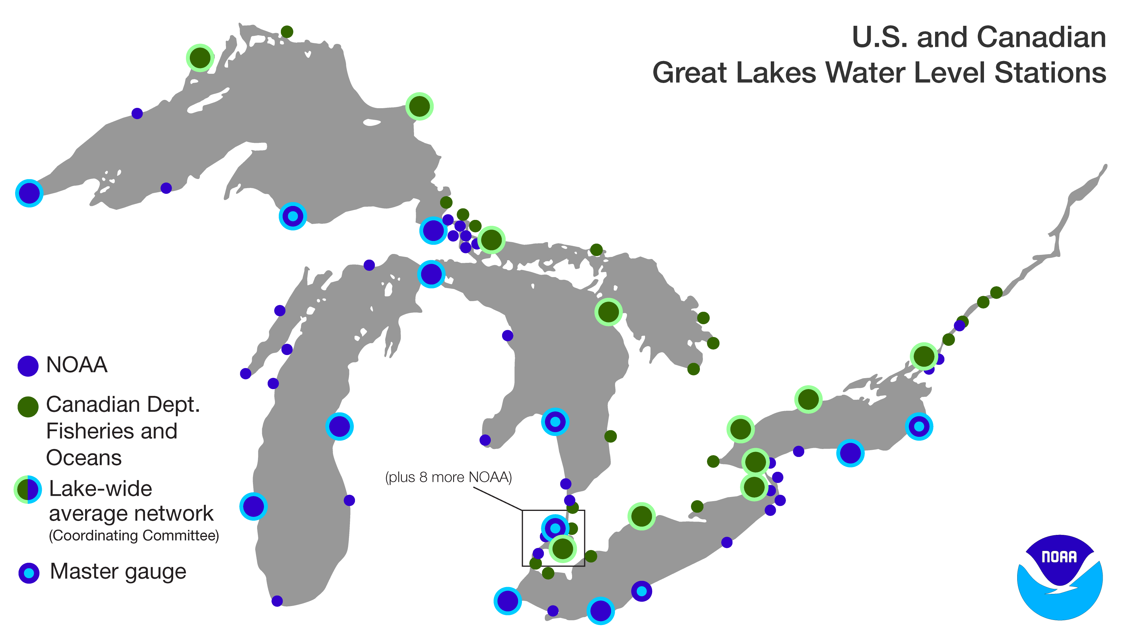
The map above shows the locations for the 53 NOAA/NOS Center for Operational Oceanographic Products and Services (CO-OPS) water level stations on the Great Lakes and connecting channels (blue circles). These stations record a 3 minute average water level every 6 minutes. The data are also archived in hourly, daily, and monthly averages. To view their data, click on the NOAA/NOS/CO-OPS icon below.
The Canadian Hydrographic Service, part of the Department of Fisheries and Oceans, monitors Great Lakes water levels on the Canadian shoreline at 33 monitoring stations (green circles above). To view their data, click on the DFO/CHS emblem below.
Lake-wide average levels are used in forecasting models and for monitoring the Great Lakes water budget. The Coordinating Committee on Great Lakes Basic Hydraulic and Hydrologic Data (from here on referred to as the Coordinating Committee), an international advisory group of government agencies, determines which water level stations are used to derive the lake-wide averages. These are shown on the map above. These data are available starting in 1918 because before that time, there were too few gauges to calculate a reasonable lake-wide average.
| Lake Superior | Lake Michigan-Huron | Lake St. Clair | Lake Erie | Lake Ontario |
| Duluth, MN | Ludington, Mackinaw City, Harbor Beach, MI | St. Clair Shores, MI | Toledo, Cleveland, Fairport, OH | Rochester, Oswego, NY |
| Marquette C.G., Pt Iroquois, MI | Milwaukee, WI | Belle River, ON | Port Stanley, Port Colborne, ON | Port Weller, Toronto, Cobourg, Kingston, ON |
| Michipicoten, Thunder Bay, ON | Thessalon, Tobermory, ON |
Each lake has one water level station that is designated as the master gauge, based on length of record and minimal relative vertical crustal movement. Current master gauge stations are shown on the map above and bolded on the lake-wide average table above.
NOAA water level observations are available at specific locations, as described on the Monitoring Network page or as a lake-wide average. These lake-wide averages are based on a select set of U.S. and Canadian station data as determined by the Coordinating Committee. The observation data shown below is from each lake's master gauge.
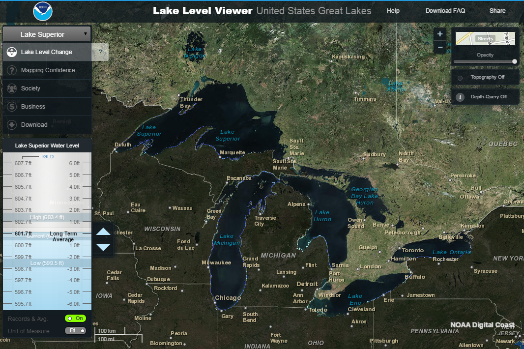
The map below shows locations of the master gauges. Near real-time data for these gauges can be viewed via the Great Lakes Water Level Dashboard. Original master gauge data can be acccessed by clicking the station locations on the map below.
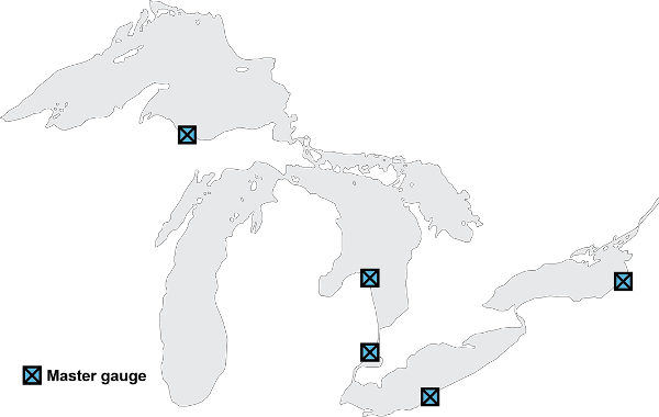
Station map: From left to right, the master gauge locations are: Marquette C.G., MI (Superior), Harbor Beach, MI (Michigan-Huron), St. Clair Shores, MI (St. Clair), Fairport, OH (Erie), Oswego, NY (Ontario).
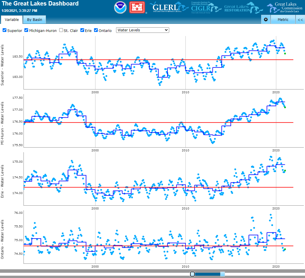
The water levels of the Great Lakes fluctuate at different time scales to different forces. Very short-term water level changes, viewable in the interactive charts above, are caused by wind and storms. These short-term (hours to days) effects can be dramatic, and can cause the lake levels from one side of the lake to the other to vary by several meters for a short time. Each of the Great Lakes has an annual rise and fall cycle driven by the timing of precipitation, snow melt, and evaporation. In general, the lakes are at their lowest levels in the winter and highest levels in summer or fall. The range in annual rise is from 11 to 20 inches.
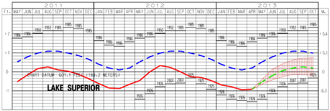
A hydrograph provides a way of seeing seasonal and decadal changes in the flow or discharge of a waterway. The hydrographs for the Great Lakes period of record (starting in 1860 or 1900) illustrate different water regimes over time.
The plots and data files below show the annual average water levels (based on lake-wide averages) for every year as well as the long-term mean level in meters, IGLD85. Click images to enlarge.
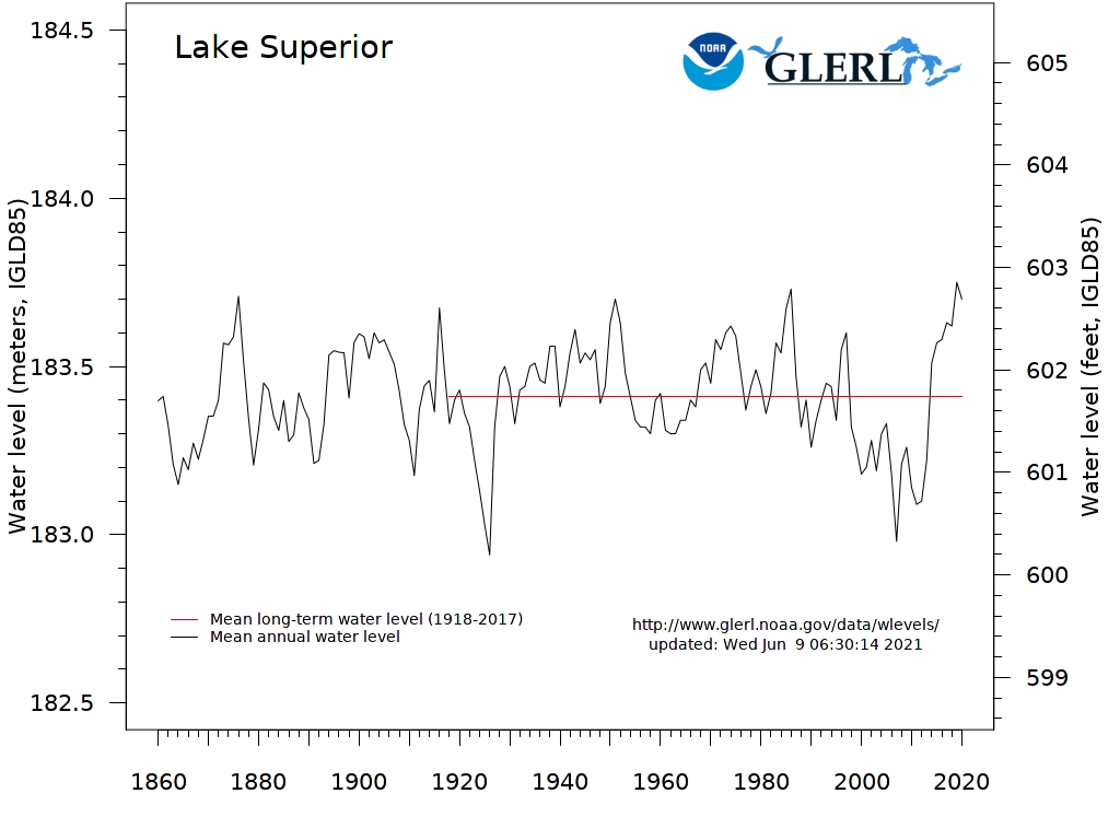 Superior Hydrograph |
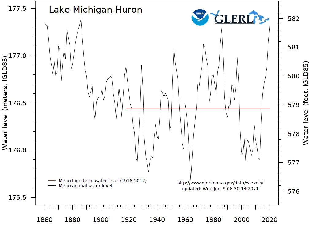 Michigan-Huron Hydrograph |
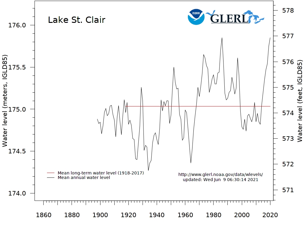 St. Clair Hydrograph |
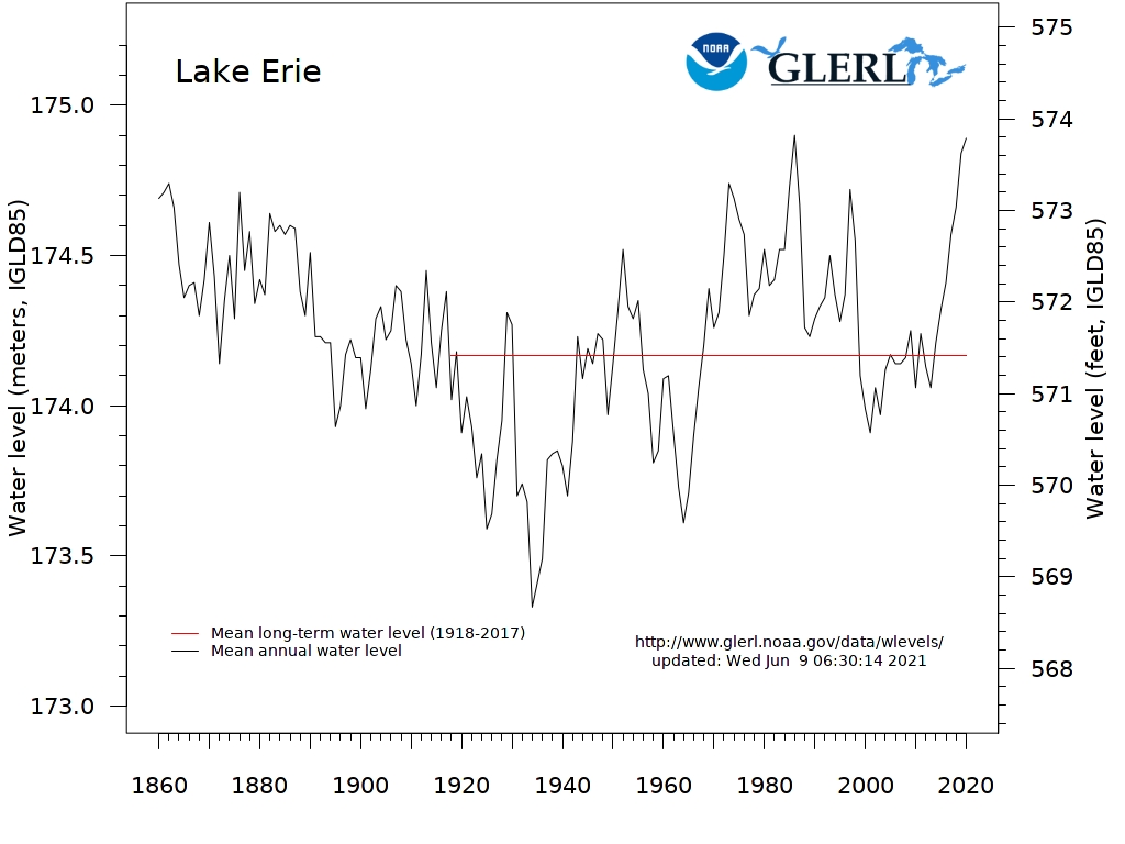 Erie Hydrograph |
 Ontario Hydrograph |
There is one official seasonal water level forecast for the Great Lakes, issued jointly by the U.S. Army Corps of Engineers - Detroit District and Environment and Climate Change Canada's Great Lakes-St. Lawrence Regulation Office during the first week of each month. These agencies have operational authority through the International Joint Commission to oversee operation of the control structures on the St. Marys River (Lake Superior outlet; Corps-Detroit) and the St. Lawrence River (Lake Ontario outlet; Corps-Buffalo). Each agency utilizes a number of tools to produce their own 6-month forecast for Great Lakes lake-wide average water levels. They collaborate to issue one joint forecast each month, which is distributed widely. The seasonal forecast is also available on each agency's website:
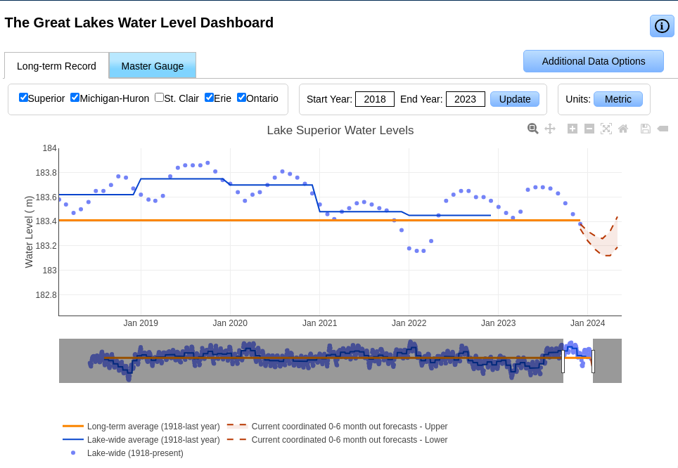
The 6-month seasonal forecasts can also be viewed on the Great Lakes Water Level Dashboard
The upgraded Great Lakes Operational Forecast System (GLOFS) was developed by GLERL in collaboration with the National Ocean Service's (NOS) Center for Operational Oceanographic Products and Services (CO-OPS) and Office of Coast Survey (OCS), and the University of Massachusetts-Dartmouth.
The National Weather Service and NOS work together to run GLOFS operationally on NOAA's High Performance Computing System. By running on NOAA's HPCS, GLOFS has direct access to National Weather Service operational meteorological products that are required for reliable operations. GLOFS uses the Finite Volume Community Ocean Model (FVCOM) and provides users with nowcast (analyses of near present) and forecast guidance of water levels, currents and water temperature out to 120 hours, four times per day.
These products are available from the National Ocean Service for each the Great Lakes:
| General Information & Media Inquiries: oar.glerl.www@noaa.gov (734) 741-2235 |
Data Inquiries: oar.glerl.data@noaa.gov |
|
