NOAA Great Lakes Environmental Research Laboratory Blog

The latest news and information about NOAA research in and around the Great Lakes

May 8, 2025
by GLERL Communications Team
0 comments

Great Lakes Ice Cover Near Average for the 2025 Season

Each spring, NOAA’s Great Lakes Environmental Research Laboratory (GLERL) conducts an analysis of how Great Lakes ice conditions progressed throughout the previous winter. This analysis, which compares the past winter’s conditions to historical trends, helps us understand the key factors that influence ice formation, how ice conditions have changed over time, and how we might predict future ice cover. Ice cover data is highly valued because it plays a critical role in both the ecology and economy of the Great Lakes region. Lake ice affects everything from snowfall and fishery populations to recreational activities and the multibillion-dollar commercial shipping industry.

The 2024-2025 winter Great Lakes ice season stayed close to long term normals following the near historic low ice levels seen in the 2023-2024 winter (Figure 1). One way that GLERL tracks ice cover is by looking at the daily percentage of ice cover across the Great Lakes, calculated by determining the area of the Great Lakes that are covered by ice and dividing that by the total surface area of the lakes. The daily percentage of ice covering each of the Great Lakes this winter is shown in the figure below.

Figure 1. Individual graphs of the percentage of ice cover of Lake Superior, Michigan, Huron, Erie, Ontario, and for all of the Great Lakes for the 2025 season.

However, despite colder temperatures than last winter, most of the lakes stayed slightly below long term averages on a daily basis through the season. Figure 2 shows 2025 daily ice cover percentages compared to 2024 ice cover values and other past seasons. Note that the 2025 ice season had an increase in ice cover compared to last year, but it did not approach record levels.

Figure 2. Daily ice cover percentage for the Great Lakes basin for 2024 (green line), 2025 (purple line) and the other years in the record 1973-2023 (blue).

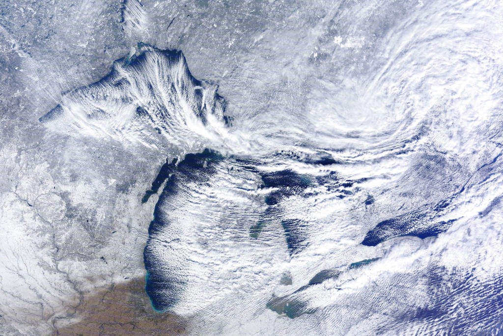
Each of the Great Lakes responds differently to seasonal changes due to unique physical characteristics—particularly their size and depth. Deeper lakes, for example, retain heat longer and may experience delayed or reduced ice cover compared to shallower ones. Similarly, larger surface areas can influence how wind and air temperature affect ice formation. Figure 3 illustrates the differences between lakes by showing the size and depth of each lake. 

Figure 3. Size comparison of length and depth for the individual Great Lakes. Graphic courtesy of Michigan Sea Grant.

Let’s compare ice cover between Lake Michigan and Lake Erie. Lake Michigan, with its relatively deep basin, tends to warm and cool more slowly than shallower Erie. As a result, Lake Michigan experiences a more gradual formation of ice and typically has lower overall ice cover. In contrast, Lake Erie, the shallowest of the Great Lakes, loses heat more quickly and develops ice cover earlier in the season. As a result, Lake Erie quickly covers with ice when air temperatures stay below freezing.

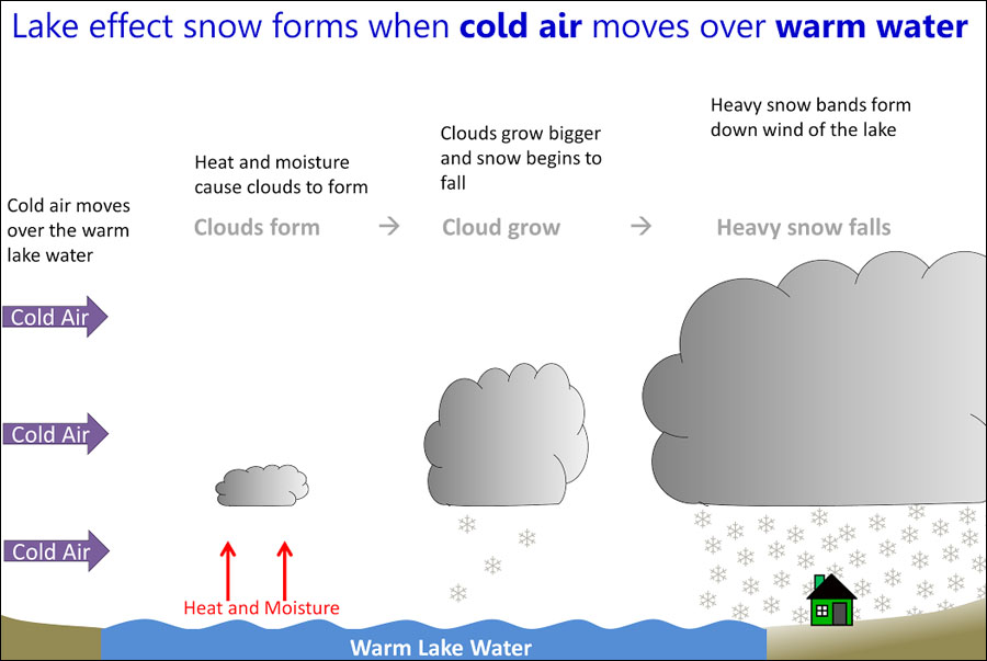
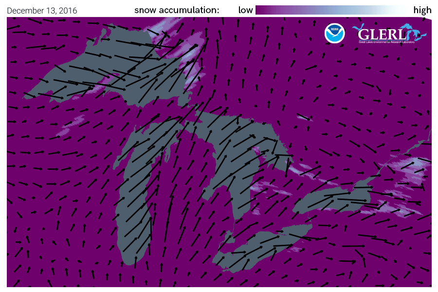
This winter season began with warm water temperatures across the Great Lakes, with little-to-no ice coverage in December. However, temperatures dropped in January and Lake Erie saw above normal ice from late January to early March (Figure 4). Lake Erie, the smallest and shallowest lake, lost heat relatively quickly while the larger lakes didn’t reach the temperatures needed for ice generation until later in the season, or only over smaller portions of the lake. 

Figure 4. Daily ice percentage for Lake Erie for 2025 (black line), long term average (red) and the other years in the record 1973-2024 (blue).

Why did Ice Percentages Peak in Late February?

The first three weeks of February were cold, with below average air temperatures allowing ice to build. A shift occurred during the 4th week of February when above normal air temperatures were recorded across the Great Lakes, reversing ice growth. Figure 5 shows the air temperatures since January 1st, 2025 for select cities across the Great Lakes. The shift from cold, below normal temperatures to warm, above normal temperatures during the 4th week of February is evident at each location, regardless of geography.

Figure 5. Temperature graphics for January 1st through April 1st, 2025 at Detroit, MI (upper left), Chicago, IL (upper right), Marquette, MI (lower left), and Buffalo, NY (lower right). Observed temperatures in 2025 are shown in dark blue, with the normal temperature ranges shaded in tan.

Seasonal Averages: A look at the numbers

The 2024-25 annual maximum ice cover is compared to the long term average in the table below, showing that overall, maximum ice cover was close to average this season.

Table 1. Annual Maximum Ice Cover (%).

The average ice coverage between January and March is shown in the table below in comparison to the full season annual max ice cover above. Ice cover was typically below average.

Table 2. Average Ice Cover from January to March (%).

The number of days with ice coverage greater than 10% is shown. The majority of lakes and the basin-wide total both indicate that this winter was slightly below long term averages.

Table 3. Number of Days of Ice Cover Duration Greater than 10%.

The tables below show how this past winter ranked with respect to records from the previous 51 years. Much of the data indicates that ice cover in general was slightly below average.

Basin-WideSuperiorMichiganHuronErieOntario
28th36th26th21st10th23rd
Table 4. Maximum Ice Percentage (%) Annual Ranking 1973 through 2025.

Basin-WideSuperiorMichiganHuronErieOntario
38th38th37th38th29th24th
Table 5. Ice Duration (Number of Days > 10%) Annual Ranking 1973 through 2025.

Basin-WideSuperiorMichiganHuronErieOntario
36th39th36th36th25th28th
Table 6. Average Ice Cover (Jan-Feb-Mar) Annual Ranking 1973 through 2025

What was happening globally that played a role in determining ice cover in the Great Lakes?

During the winter, ice cover on the Great Lakes is influenced by four large-scale climate patterns from the Atlantic and Pacific: the North Atlantic Oscillation (NAO), the Atlantic Multidecadal Oscillation (AMO), the El Niño-Southern Oscillation (ENSO), and the Pacific Decadal Oscillation (PDO). These patterns describe conditions that can lead to above average or below average temperatures in the Great Lakes, depending on their position. In February, both the AMO and PDO drove strong and steady warming during the entire ice season – except for the month of February. February was marked by below-average air temperatures, including a 16-day streak of colder than normal weather in the middle of the month. While the NAO stayed near normal, while ENSO was in a cooling phase. On February 22, the ENSO-induced cooling caused ice cover to briefly peak at 52% but conditions quickly warmed, which correlates with the status of global climate patterns at that time (the 3rd warmest February). The strong warming effects from AMO and PDO meant the brief increase in ice cover linked to ENSO didn’t last long. GLERL predicted at mid-December and mid-January a similar but slightly higher range of maximum ice cover (between 53–66%) than occurred. These predictions are provided each year by a statistical ice coverage model based on the four climate patterns.

April 24, 2025
by GLERL Communications Team
0 comments

Seining Season: Studying the Future of Great Lakes Whitefish

Each spring biologists from the NOAA Great Lakes Environmental Research Laboratory (GLERL) head out to the beaches along Lake Michigan to check in on juvenile lake whitefish. This popular, mild-tasting native species is the most popular commercial fish in the Great Lakes. Our scientists use special nets to count juvenile whitefish and keep tabs on how these fish are faring as the Great Lakes change. Numbers show that the species has declined dramatically, and GLERL is working to determine what is causing this.

What is a Lake Whitefish?

Lake whitefish from Lake Ontario. Note smaller body size of top and bottom fish. November 2000. Credit: J. Hoyle, Ontario Ministry of Natural Resources.

Lake whitefish (Coregonus clupeaformis) are a native species to the Great Lakes that are a popular and valuable commercial fish. Related to salmon and trout, they are prized for their exceptional flavor and are economically valuable to the Great Lakes. They live and feed in the benthic zone of the lakes – in the dark, cool depths near the lake bottom. Lake whitefish prefer cool water and spend much of their time offshore except during the spawning run in late fall where they migrate to shallow reefs, rocky channels, and rivers to lay their eggs. Eggs then overwinter in those locations and hatch in the early spring, when the larval fish begin looking for food. Their diet historically consisted of an energy-rich, shrimp-like amphipod called diporeia. However, diporeia have been in drastic decline in the Great Lakes over the past several decades, so lake whitefish must find poorer quality food such as mussels, other invertebrates, and small fish to eat.

Why are Lake Whitefish Popular?

Lake whitefish have long been an important commercial fishery in the Great Lakes. According to the Michigan Sea Grant, in 2020 they made up 89 percent of the catch in Michigan commercial fisheries and 95 percent of the sales. Well known for their mild flavor they are likely to end up on restaurant menus throughout the Great Lakes region and beyond. They also support a popular recreational fishery for ice anglers on Green Bay, where over 110,00 fish are caught annually, as well as smaller recreational fisheries around piers throughout the Great Lakes.

Lake whitefish caught by ice fisher Jeff Elliott, biologist with the NOAA Great Lakes Environmental Research Laboratory. Credit: Jeff Elliott.

What is Affecting the Status of Whitefish Populations?

Lake whitefish are showing a decline throughout much of the Great Lakes, especially in the main basin of Lake Michigan. According to the Great Lakes Fishery Commission, commercial harvest in the early 1990s was around 8 million pounds a year, but by 2020, harvests had declined to just above 2 million pounds a year. Recruitment describes the critical process through which fish populations regenerate themselves by laying eggs, producing larval fish that can thrive when conditions and food supplies are optimal before transitioning to mature fish that become desirable for catch. Researchers from GLERL along with partners from other agencies and tribes are working to identify what factors are affecting whitefish recruitment, and identify any recruitment bottlenecks that are contributing to the decline of whitefish populations.

Lake whitefish life cycle: it takes 5 to 7 years for a whitefish to mature to adulthood. Credit: Michigan Sea Grant. https://www.michiganseagrant.org/topics/ecosystems-and-habitats/native-species-and-biodiversity/lake-whitefish/

How are We Investigating Whitefish Recruitment?

Beach seine net being deployed by biologists from NOAA’s Great Lakes Environmental Research Laboratory in Grand Haven, Michigan. Credit: NOAA/GLERL.

After hatching in late winter, larval lake whitefish spend their time in the nearshore areas of the lakes. They need a steady supply of food in order to thrive and grow, typically eating zooplankton in the water. Researchers are able to capture larval fish for studies in this habitat by manually pulling a seine net along the beach. The seine is a 150 foot long mesh net that is pulled out from the beach and then manually worked back towards the shore. Any fish captured in the seine are concentrated to the back of the net for easier sorting.

Biologists from the Great Lakes Environmental Research Laboratory seining for larval lake whitefish in Muskegon, Michigan. Credit: NOAA/GLERL.

Spottail shiners, banded killifish, round gobies, and emerald shiners are all common bycatch species; those are counted and returned to the water. Any whitefish captured are counted, measured, and their diet is analyzed by examining their stomach contents under a microscope. Additionally, lake and weather conditions are recorded, such as water temperature, dissolved oxygen, pH, substrate, wave height, wind speed and direction. A zooplankton sample is also taken to allow researchers to compare what’s in the water to what the whitefish have eaten to estimate how much food is available to them.

Larval lake whitefish caught by GLERL biologists in a seine net. Credit: NOAA/GLERL.

Biologists at GLERL’s Lake Michigan Field Station in Muskegon, MI have been using seine nets to sample larval whitefish on the beaches near Muskegon, Grand Haven, and Montague every spring since 2014. This long term dataset is important for understanding the health of the fishery as it takes whitefish five to seven years to recruit to full adulthood. Once larval whitefish have been captured at each site and examined in the laboratory, GLERL biologists can study ecological changes that are happening over time to understand how likely young fish will be recruited to adult stages and become part of the commercial fishery.

How are Larval Whitefish Doing?

Captured larval lake whitefish swimming in container. Credit: NOAA/GLERL.

During most years, larval fish numbers have been low in GLERL sampling in southeast Lake Michigan, indicating there will be fewer fish to grow to adult life phases than historical numbers show. Furthermore, even during the years when catch numbers were highest, there was little evidence in subsequent surveys of mature whitefish by the Michigan Department of Natural Resources that these fish survived to adulthood, reflecting poor recruitment. One reason may be that these fish do not have enough food to quickly grow beyond the larval stage (where they are vulnerable to predators or starvation). GLERL’s diet analyses indicate that larval lake whitefish require certain types and sizes of food at different phases of life. In order to thrive, larval whitefish and the right types of food (i.e., different species of zooplankton or larger prey) have to be in synchrony in order for the whitefish to successfully survive and grow into their next stage of life. Many factors can affect this harmony, including competitors such as invasive mussels, predators, and how winter and spring weather conditions are suitable for both plankton and fish larvae. GLERL’s research is used by fishery managers to determine how to manage sustainable and profitable fisheries in Lake Michigan and the other Great Lakes. Beach seining surveys of larval whitefish have become a critical clue on why fishery catches have dropped in the Great Lakes. This study is very important to fishery managers who are working to ensure Great Lakes fisheries are sustainable and profitable, and people are able to enjoy whitefish on their table for many years to come.

March 24, 2025
by GLERL Communications Team
0 comments

Following the Great Lakes’ Most Unwanted

GLANSIS Database Keeps Tabs on Biological Invaders

The mouth of an invasive sea lamprey, one of the most notorious Great Lakes invasive species. Photo credit: Dave Brenner, Michigan Sea Grant.

The Great Lakes are one of the most unique freshwater ecosystems in the world – but are also heavily threatened by biological invaders. Aquatic invasive and nuisance species are the plants and animals from other regions of the globe that accidentally get brought to the Great Lakes, potentially destroying the local ecosystem. Many species pose a significant threat to the Great Lakes environment and economy, from sea lamprey that devastate prized fisheries, zebra mussels that encrust underwater infrastructure, and aquatic weeds that entangle boat motors and swimmers alike. There are nearly 200 nonindigenous aquatic species currently present in the Great Lakes, many of which have significant environmental and socioeconomic impacts, and keeping track of them across the region is a daunting task. The Great Lakes Aquatic Nonindigenous Species Information System (GLANSIS) is designed to meet this challenge, providing a “one-stop shop” for comprehensive information about aquatic invaders.

GLANSIS is based out of NOAA’s Great Lakes Environmental Research Laboratory (GLERL) and is the Great Lakes hub of the USGS Nonindigenous Aquatic Species (NAS) database. According to Acting GLERL Director Dr. Jesse Feyen, “GLERL experts have long studied the impacts of current and potential invaders in the Great Lakes. As the long-standing home for GLANSIS, our goal is to get the message out about the significant risks they pose.” With funding from the Great Lakes Restoration Initiative (GLRI), the site provides the best available information to limit the introduction, spread, and impact of aquatic invasive species in the Great Lakes. GLANSIS provides a comprehensive set of tools including species profiles, a custom-generated list of invaders, a mapping tool, risk assessments, and more. While GLANSIS was originally designed for use by scientists and environmental managers, this publicly-accessible tool is used by teachers, students, anglers, property owners, and anyone who wants to learn more about stopping invasive species in the Great Lakes. Citizens and stakeholders can help protect their local waterways by learning how to recognize, report, and stop the spread of aquatic invasive species.

The Great Lakes’ Most Unwanted

As of 2025, GLANSIS maintains species profiles of 192 nonindigenous aquatic species that are successfully reproducing and overwintering in the Great Lakes, including fish, plants, invertebrates, algae, and even parasites and diseases. GLANSIS conducts a thorough risk assessment process on all species which facilitates direct comparisons of their impacts, as shown in a recent paper on the top 10 most impactful invaders published in the Journal of Great Lakes Research.

GLANSIS also hosts data on “watchlist” species – plants, animals, and pathogens that have not yet established lasting populations in the Great Lakes, but have been identified by experts as emerging threats. These include invasive silver and bighead carp, which have caused devastating ecological impacts to native fish and plants as they have expanded through other US waterways, as well as aquarium plants and pets like the self-cloning marbled crayfish, where even a single individual can launch a new invasive population.

Invasive silver carp are not reproducing and overwintering in the Great Lakes – yet. Photo credit: Dan O’Keefe, Michigan Sea Grant.

The GLANSIS team recently brought together more than a dozen invasive species experts for a real-time virtual review to provide new data on more than 50 non-native species that are either already present in the Great Lakes basin or have been identified as an emerging threat. These efforts ensure that the information in the database remains accurate, timely and relevant to environmental managers, educators, and other user groups who rely on GLANSIS for decision-making about aquatic invasive species.

To learn more about GLANSIS and explore the database yourself, visit https://www.glerl.noaa.gov/glansis/ or contact GLANSIS Program Manager Rochelle Sturtevant at rochelle.sturtevant@noaa.gov.

February 26, 2025
by Gabrielle Farina
0 comments

NOAA GLERL director retires after 40-year career in managing America’s water resources

After more than 40 years of civil service, Deborah Lee, NOAA Great Lakes Environmental Research Laboratory (GLERL) director, is retiring on February 28, 2025. Known for her passion for managing our nation’s water resources, Lee has been a dedicated and innovative steward of our nation’s freshwater, benefiting people, the environment, and the economy.

A GLERL hydrologist at the time, Lee stands at the NOAA GLERL sign with colleagues Frank Quinn, Tom Croley, and Dave Reid in the 1990s.

As an award-winning and nationally recognized engineer and professional hydrologist, Lee’s career was divided between time at NOAA and the U.S. Army Corps of Engineers. Early in her career she served as a hydrologist at NOAA GLERL and then for the NOAA National Weather Service (NWS) Ohio River Forecast Center. Her leadership and management skills grew and were acknowledged during her time with the U.S. Army Corps of Engineers where she served as Chief of the Water Management of the Great Lakes and Ohio River Division and as its Acting Regional Business Director.

Lee is awarded a Superior Civilian Service Award on her last day serving at the U.S. Army Corps of Engineers.

As GLERL director over the past ten years, Lee applied her expertise in the region to create partnerships that accelerated GLERL’s research to application on some of the Great Lakes most pressing issues. She oversaw the transitioning from research to operations of NOAA’s Harmful Algal Bloom (HAB) forecast to NOAA’s National Centers for Coastal Ocean Science, and of the Great Lakes Operational Forecast System (GLOFS) to NOAA’s Center for Operational Oceanographic Products and Services. The GLOFS is used by NWS to predict Great Lakes water levels, temperature, currents and waves in its marine forecasts, and by the U.S. Coast Guard for search and rescue operations. She also fostered GLERL’s ‘Omics program and the important research that predicted the potential impact to the fishery from invasive carp. 

Lee celebrates the 50th anniversary of NOAA’s Great Lakes Environmental Research Laboratory in 2024.

Lee’s legacy reaches far beyond NOAA. First, with her position as Regional Team Lead for NOAA’s Great Lakes Regional Collaboration Team, she represented NOAA in the execution of the binational Great Lakes Water Quality Agreement with Canada and led NOAA’s mission under the Great Lakes Restoration Initiative where she built several successful regional coalitions across the U.S. and Canada and with private industry. Her creativity, adaptability and resilience helped her align these program efforts with NOAA’s vision, mission, and goals in partnering with stakeholders inside and outside of NOAA. She also served as the U.S. Co-chair of the International Joint Commission’s Science Advisory Board’s Research Coordination Committee. Always open to new and challenging assignments, Lee took on the leadership roles as the Co-chair of the Aquatic Nuisance Species Task Force and as Senior Advisor to the National Invasive Species Council.

Lee receives Lifetime Achievement Award from the Environmental & Water Resources Institute of the American Society of Civil Engineers in 2024.

Lee has been recognized with numerous professional awards throughout her career, including The Ohio State University Distinguished Alumni Award, the American Society of Civil Engineers Environmental Water Resources Institute Lifetime Achievement Award and President’s Medal, and nominated by Eminence to the American Academy of Water Resources Engineers.

Join us in thanking Director Lee for her profound impact on NOAA Research and the Great Lakes region throughout her remarkable career!

February 14, 2025
by Gabrielle Farina
0 comments

Fall in love with the science behind NOAA GLERL’s valentines

Happy Valentine’s Day from NOAA’s Great Lakes Environmental Research Laboratory! Here’s a look at the Great Lakes science that inspired our GLERL-themed valentines.

Lake Erie’s central basin is a vital drinking water source for over two million people along the Ohio coast, but drinking water treatment plants in this region face significant challenges during the summer. The lake water stratifies, creating a distinct separation between warm surface water and cold, dense bottom water. The deep water often becomes hypoxic (low in dissolved oxygen) and has a low pH and elevated levels of iron and manganese. This hypoxic environment is typically inhospitable to many animals. Strong wind events can cause upwelling, bringing this cold, hypoxic bottom water to the surface near the lakeshore, which can interfere with the drinking water treatment process.

To address this issue, NOAA GLERL and the Cooperative Institute for Great Lakes Research developed a forecast model of hypoxia and circulation in Lake Erie to alert decision makers of when upwelling may bring hypoxic water to the shore. The hypoxia forecast is now being maintained by NOAA’s National Centers for Coastal Ocean Science. Learn more

Remote sensing is the science of obtaining information about objects or areas from a distance, typically from aircraft or satellites. One method of remote sensing is the use of airborne hyperspectral cameras, which contain many more bands of discrete wavelengths than photos from a typical camera. NOAA GLERL scientists use these images to study properties like turbidity and chlorophyll during the winter and harmful algal blooms in the summer.

NOAA GLERL’s experimental Great Lakes Coastal Forecasting System (GLCFS) is an experimental set of hydrodynamic computer models that predict lake circulation and other physical processes, such as thermal structure, wind, short-term water level changes, and ice dynamics. These research models provide timely information on currents, water temperatures, short-term water level fluctuations (e.g. seiche, storm surge), and ice out to 120 hours into the future.

NOAA GLERL has been exploring the relationships between ice cover, lake thermal structure, and regional atmospheric patterns for over 30 years. Our research focuses on historical model simulations and observations of ice cover, surface water temperature, and other variables. Studying, monitoring, and predicting ice cover on the Great Lakes is important because ice plays an important role in determining regional weather, timing of evaporation, water movement patterns, water temperature structure, and spring plankton blooms.

Harmful algal blooms (HABs) in the Great Lakes occur when algae grow rapidly, forming dense scums and water discoloration. Some blooms can produce neurotoxins, liver toxins, or skin irritants and can be very dangerous to come into contact with. These blooms can contaminate drinking water, harm swimmers and pets in areas where toxins are concentrated, and pose a severe nuisance to recreational and commercial boating and fishing.

NOAA GLERL’s HAB research focuses on understanding and predicting blooms by integrating monitoring and real-time observations, forecasting and 3-D modeling, and remote sensing. NOAA GLERL research on the formation, duration and toxicity of HABs is used to create products for stakeholders, coastal communities, and the public for making important decisions, such as managing drinking water treatment plants. Learn more and access NOAA GLERL’s HAB data.

Much of NOAA GLERL’s Great Lakes science would not be possible without our fleet of research vessels. The R/V Laurentian is NOAA GLERL’s largest vessel and one of our most important assets. Added to our research fleet in 2002, the 80-foot vessel has many unique features that make it a fundamental component of our Great Lakes science. The Laurentian is based out of GLERL’s Lake Michigan Field Station in Muskegon, MI and supports a large portion of our ecosystem research, including lower food web dynamics, benthic surveys, and winter ecology.

NOAA GLELRL’s Realtime Coastal Observation Network (ReCON) consists of high-tech buoys across the Great Lakes that collect meteorological data as well as chemical, biological, and physical data below the lake surface. In the western basin of Lake Erie and Lake Huron’s Saginaw Bay, our buoys help us monitor algal bloom conditions in near real time.

December 19, 2024
by Gabrielle Farina
0 comments

NOAA GLERL prepares for 2025 ice season

As we settle into winter in the Great Lakes region, many people are looking to NOAA’s Great Lakes Environmental Research Laboratory for information about the 2025 ice season. Here are some common questions about this year’s ice and our ice research, answered by a team of NOAA GLERL scientists.

What is the Great Lakes ice forecast for 2025?

The U.S. National Ice Center’s official seasonal outlook for Great Lakes ice predicts slightly below normal ice conditions on Lakes Superior, Michigan, Huron and Erie this winter. Near normal ice conditions are predicted for Lake Ontario. Read the full outlook here.

How does NOAA GLERL research ice cover?

NOAA GLERL has been exploring the relationships between ice cover, lake thermal structure, and regional climate for over 30 years through historical model simulations and observations of ice cover, surface water temperature, and other variables. Studying, monitoring, and predicting ice cover on the Great Lakes is important because ice plays an important role in determining regional weather, timing of evaporation, water movement patterns, water temperature structure, and spring plankton blooms.

NOAA GLERL and the U.S. National Ice Center have been collecting detailed ice cover data via satellite imagery since 1973. When it comes to analyzing each year’s data, we compare the current year to historical data in two major ways. The annual maximum ice cover (AMIC) is simply the highest measurement of ice cover that we see in a single ice season. While it’s interesting to look at peak ice cover every year, we also look at average ice cover throughout the entire season. Generally, looking at seasonal average ice cover is more relevant than AMIC for studying long term trends. For example, a short-lived cold air outbreak can cause a peak in maximum ice cover, even if the seasonal average was low for the rest of the year.

When does the Great Lakes ice season start?

The northern Great Lakes can start to see ice as early as late November or early December. NOAA GLERL begins tracking ice cover and updating our ice products for the season in early December. Low ice cover in December is normal, with the majority of ice growth historically occurring in January and February. Ice cover for mid-December typically runs between 1-2%. Access lakewide ice cover data for the 2025 season here.

“We expect a mild ice season in 2025,” says Dr. Jia Wang, ice climatologist at NOAA GLERL. Interannual variability of Great Lakes ice cover is heavily influenced by four large-scale climate patterns, referred to as teleconnections: the North Atlantic Oscillation (NAO), the Atlantic Multidecadal Oscillation (AMO), the El Nino/Southern Oscillation (ENSO) and the Pacific Decadal Oscillation (PDO). 

“This year, both AMO and PDO are bringing very strong warm weather conditions to the Great Lakes region,” says Dr. Wang. “This will overwhelm the cooling caused by this year’s neutral ENSO conditions, so a mild winter is likely.” 

What ice products and resources does NOAA GLERL have?

The NOAA Great Lakes Coastwatch Program provides satellite environmental data and products for near real-time observation of the Great Lakes. CoastWatch products help support water-dependent industries such as hydropower, fishing, commercial shipping, and search and rescue operations. The CoastWatch Great Lakes Ice Concentration Statistics page includes graphs and datasets for lakewide average ice concentrations, as well as comparisons to historical data.

Graph of Lake Superior average ice concentrations, 1973-2025.

The CoastWatch Great Lakes Surface Environmental Analysis (GLSEA) is a digital map of Great Lakes surface water temperature and ice cover, and is produced daily and derived from NOAA satellite imagery. Lake surface temperatures and ice cover conditions are updated daily with information from the cloud-free portions of the previous day’s satellite imagery.⁣

Daily GLSEA map from NOAA Great Lakes CoastWatch.

The Experimental Great Lakes Coastal Forecasting System (GLCFS) is an experimental set of hydrodynamic computer models that predict lake circulation and other physical processes, such as thermal structure, wind, short-term water level changes, and ice dynamics. Access GLCFS ice animations for each lake below.

GLERL’s 2025 Ice Cover page includes daily ice cover maps and a Great Lakes average ice cover graph.

Daily ice charts available on NOAA GLERL’s 2025 Ice Cover page.
Great Lakes average ice cover graph available on NOAA GLERL’s 2025 Ice Cover page.

Our Historical Ice Cover page provides graphs and datasets for historical Great Lakes ice cover back to 1973. Our historical ice data is critical to predictive modeling efforts and establishes a foundation for understanding the influence of ice on the regional economy and environment.

Animated map showing maximum Great Lakes ice cover from 1973 to 2024. Access an interactive version here.

To better understand ice formation and the types of ice in the Great Lakes, NOAA GLERL and the U.S. Coast Guard use Synthetic Aperture Radar (SAR) data from the NOAA CoastWatch Great Lakes Node to monitor six different types of ice, ice thickness, and ice cover. This risk assessment tool is known as the Ice Condition Index (ICECON). The U.S. Coast Guard uses ICECON to identify areas that require ice breaking operations and ship transit assistance. These ice breaking operations allow government and commercial ships to travel through the Great Lakes unobstructed.

ICECON image of Lake Huron from January 2023 via NOAA Great Lakes CoastWatch.

All of NOAA GLERL’s ice products are also accessible from our Great Lakes Ice Cover homepage.

Why do NOAA GLERL’s ice records only go back to 1973?

The early 1970s is when we first had reliable satellite data with which to construct more accurate and complete datasets. Before the satellite era, information during the winter about ice concentration away from the shoreline was very limited. This is why we only use the 52-year dataset for our calculations, as this represents the highest quality data.

Is ice cover related to evaporation and water levels?

To form ice, the lake’s surface requires a loss of heat and moisture from evaporation in the late fall and early winter. While Great Lakes water levels are generally lowest in the winter, most of the evaporation from the lakes actually happens in the fall. This is because in the fall, cooler and drier air flows over the warmer lake waters. This contrast in temperature and moisture between the air and water helps to increase the evaporation from the water, causing a decline in water levels. Once ice has formed on the lake, its presence does reduce the amount of evaporation at that time. 

The graphic below illustrates the seasonal cycles that Great Lakes water levels undergo every year. Learn more about Great Lakes water levels and water temperatures in our recent pre-winter Q&A.

Graphic showing land in the background and water in the foreground, divided into four panels corresponding with the seasons. Text describes the water level changes throughout the year: Winter low, spring rise, summer peak, and fall decline.
Infographic showing seasonal water level changes on the Great Lakes.

Why is ice cover important?

Great Lakes communities have strong economic ties to ice cover on the lakes, and changes in ice cover can have big impacts on the people living there. Many local businesses in the region rely on ice fishing and outdoor sports, which can only happen if the ice is thick and solid. Commercial shipping schedules are heavily impacted by the formation of ice as well.

Ice is a natural part of the Great Lakes yearly cycle and many animal species, from microbial to larger fauna, rely on the ice for protecting young and harboring eggs. There’s increasing evidence that the ice plays a role in regulating many biological processes in the water throughout the winter. The Great Lakes also see most of their significant storms and large wave events during the colder months of late fall through winter. The shorebound ice sheets act as an important buffer against these waves, protecting the coast from erosion and damage to shoreline infrastructure.

Additional Resources

Fact Sheet: Ice Cover Research at NOAA GLERL

NOAA GLERL Ice Cover Homepage

NOAA GLERL ice cover photos

December 2, 2024
by Gabrielle Farina
0 comments

Lake effect snow: What, why and how?

MODIS satellite image of a lake effect snow event in the Great Lakes, caused by extensive evaporation as cold air moves over the relatively warm lakes. November 20, 2014. Credit: NOAA Great Lakes CoastWatch.

What is lake effect snow?

In the Great Lakes region, hazardous winter weather often happens when cold air descends from the Arctic region. Lake effect snow is different from a low pressure snow storm in that it is a much more localized and sometimes very rapid and intense snow event. As a cold, dry air mass moves over the unfrozen and relatively warm waters of the Great Lakes, warmth and moisture from the lakes are transferred into the atmosphere. This moisture then gets dumped downwind as snow.

Graphic via NOAA National Weather Service

Lake Effect Snow Can Be Dangerous

Lake effect snow storms can be very dangerous. For example, 13 people were killed by a storm that took place November 17-19, 2014 in Buffalo, New York. During the storm, more than five  feet of snow fell over areas just east of Buffalo, with mere inches falling just a few miles away to the north. Not only were lives lost, but the storm disrupted travel and transportation, downed trees and damaged roofs, and caused widespread power outages. Improving lake effect snow forecasts is critical because of the many ways lake effect snow conditions affect commerce, recreation, and community safety. 

Why is lake effect snow so hard to forecast?

There are a number of factors that make lake effect snow forecasting difficult. The widths of lake-effect snowfall bands are usually less than 3 miles — a very small width that makes them difficult to pinpoint in models. The types of field measurements scientists need to make forecasts better are also hard to come by, especially in the winter!  We would like to take frequent lake temperature and lake ice measurements, but that is difficult to do during the winter, as conditions are too rough and dangerous for most research vessels and buoys. (However, NOAA is making progress towards expanding our Great Lakes winter observation capabilities!)

Satellite measurements can also be hard to come by, as the Great Lakes region is notoriously cloudy in the winter. It’s not uncommon to go for over a week without usable imagery.

Lake Effect Snow animation: This mid-December 2016 lake effect snow event resulted in extremely heavy snow across Michigan, Ohio, upstate New York as well as the province of Ontario east of Lake Superior and Huron.

NOAA GLERL and CIGLR work to improve lake effect snow forecasting

Currently, NOAA Great Lakes operational models provide guidance for lake effect snow forecasts and scientists at NOAA GLERL and the Cooperative Institute for Great Lakes Research (CIGLR) are conducting studies to improve them. 

They use data from lake effect snow events in the past and compare how a new model performs relative to an existing model.  One way to improve forecast model predictions is through a model coupling approach, or linking two models so that they can communicate with each other. When they are linked, the models can share their outputs with each other and produce a better prediction in the end.

Research published by CIGLR, GLERL and other research partners, “Improvements to lake-effect snow forecasts using a one-way air-lake model coupling approach,” is part of a series of studies (see list below) that help to make lake effect snow forecasts better. This study takes a closer look at how rapid changes in Great Lakes temperatures and ice impact regional atmospheric conditions and lake-effect snow. Rapidly changing Great Lake surface conditions during lake effect snow events are not accounted for in existing operational weather forecast models. The scientists identified a new practical approach for how models communicate that does a better job of capturing rapidly cooling lake temperatures and ice formation. This research can result in improved forecasts of weather and lake conditions. The models connect and work together effectively and yet add very little computational cost. The advantage to this approach in an operational setting is that computational resources can be distributed across multiple systems.

Study model run: This panel of images shows model runs that looks at data from a lake effect snow event from January 2018 with and without the new type of model coupling. The image on the far right labeled Dynamic – Control Jan 06 shows the differences in air temperature (red = warmer, blue = colder) and wind (black arrows) when the models are coupled. The areas in color show how the new model coupling changed the model output considerably and improved the forecast.

Our lake effect snow research continues

Our lake effect modeling research is ongoing, and NOAA GLERL, CIGLR, NOAA NWS Detroit, the NOAA Global Systems Laboratory continue to address the complex challenges and our studies build upon each other to improve modeling of lake-effect snow events. A future focus will be on running the models on a smaller grid scale and continuing to work to improve temperature estimates as both are key to forecasting accuracy. 


Related news articles and blog posts: 

Improving Lake Effect Snow Forecasts

Improving lake effect snow forecasts by making models talk to each other

Related research papers: 

Fujisaki-Manome et al. (2022) Forecasting lake-/sea-effect snowstorms, advancement, and challenges

Fujisaki-Manome et al. (2020) Improvements to lake-effect snow forecasts using a one-way air-lake model coupling approach. 

Anderson et al. (2019) Ice Forecasting in the Next-Generation Great Lakes Operational Forecast System (GLOFS)

Fujisaki-Manome et al. (2017) Turbulent Heat Fluxes during an Extreme Lake-Effect Snow Event

Xue et al. (2016) Improving the Simulation of Large Lakes in Regional Climate Modeling: Two-Way Lake-Atmosphere Coupling with a 3D Hydrodynamic Model of the Great Lakes

November 26, 2024
by Gabrielle Farina
1 Comment

Pre-winter Q&A with NOAA GLERL scientists: Water levels, lake temperatures, and winter outlooks for the Great Lakes region

December is just around the corner, and many residents of the Great Lakes region have questions surrounding water levels on the lakes and the upcoming winter season. Here are some common questions about lake levels, water temperatures, winter outlooks, and ice cover, answered by a team of NOAA GLERL scientists.

Why are Great Lakes water levels going down right now?

Great Lakes water levels undergo a relatively consistent seasonal pattern year after year, with lower levels in the winter and higher levels in the summer. During the winter, precipitation falls as snow and accumulates on land. In the spring, increased precipitation and melting snow add water to the lakes, causing a rise in water levels. Peak levels occur in summer to early fall. In the fall, cooler and drier air flows over the warmer lake waters. This contrast in temperature and moisture between the air and water helps to increase the evaporation from the water. The graphic below illustrates the seasonal cycles that Great Lakes water levels go through every year.

Why are lake levels falling below their long-term average this year?

In addition to their regular fall decline, some of the Great Lakes—notably Lake Superior and Lake Michigan-Huron—are experiencing water levels that are slightly below their long-term average for this time of year. (Note that because they are connected by the Straits of Mackinac, Lakes Michigan and Huron are actually considered one lake when it comes to hydrology!)

“It is noteworthy that this year is the first time since 2014 that we’ve seen the monthly mean on Lake Michigan-Huron being slightly below the long-term average,” says Dr. Lauren Fry, NOAA GLERL Physical Scientist. “The drivers of water levels are the precipitation over the lakes, the runoff into the lakes, and the evaporation from the lakes. It’s a combination of those influences that drive how the water levels change on a seasonal, annual, and interannual basis. Over the past few months we’ve seen below-average precipitation, which is contributing to the slightly below average levels we’re seeing this fall.”

This graphic illustrates how Great Lakes water levels are determined by the net flow of water in and out of the Great Lakes, or the net basin supply.

Dr. Fry also notes that warmer temperatures in October were a contributing factor, as this helped keep lake temperatures warm, ultimately enhancing the evaporation we’re seeing from the lakes.

Is this change normal?

In addition to fluctuating seasonally, Great Lakes water levels fluctuate between high and low periods on a multi-year timescale. The lakes have been experiencing above-average water levels since 2014, culminating in record high water levels occurring between 2017-2020, depending on the lake. This transition period highlights the need to be prepared for variability between multi-year periods of high levels and low levels in the future.

These long-term water level graphs illustrate how Great Lakes water levels (blue lines) fluctuate between above and below the long-term average (red lines) on seasonal and multi-year timescales. (Credit:U.S. Army Corps of Engineers, Detroit District)

What are the impacts of lower lake levels? 

During periods of low water, lake access can become an issue. Docks can be higher than they’re supposed to be, making it more difficult to board a boat from its dock. Conversely, those with lower docks may benefit from the lower levels. 

With more land exposed during low water periods, vegetation has more space to spread out and grow along the shoreline. This can be beneficial for coastal wetland ecosystems, but can potentially make recreational areas harder to access.

The commercial shipping industry can also be impacted by low water levels, as crucial shipping areas become shallower when the water is low. Vessels may be able to carry less cargo weight as a result, and may even need to avoid particularly shallow areas altogether.

On the plus side, we can expect to see less erosion during periods of low water levels compared to erosion when water levels are high.

Learn more about water level impacts from the International Joint Commission.

Are lake temperatures warmer than average?

Year-to-date temperatures

Lakes Michigan, Huron, Erie and Ontario have all experienced record high year-to-date (YTD) average surface temperatures in 2024 so far, compared to NOAA GLERL’s 30-year satellite record. This is partially due to the warm fall we’re experiencing now, but also due to the notably warm 2023-2024 winter. 

While the Great Lakes region has definitely had a warm fall, it’s not as extreme as the preceding warm winter. The combination of the two warmer-than-average seasons have led to a record warm year-to-date average for all lakes except Superior.

This table shows each lake’s average surface temperature for January 1 – November 24 for 2024, as well as the long-term average, minimum, and maximum for year-to-date average lake temperatures on record. For example, 40.3°F is Lake Superior’s lowest YTD average on GLERL’s 30-year record.

For the four lakes that are currently at record high YTD averages, their previous record highs all occurred in 2012. Each lake’s previous 2012 record (°F) is listed below.

Michigan: 53.3
Huron: 51.5
Erie: 56.2
Ontario: 54.8

Lake Superior’s existing record high YTD average of 47.9°F occurred in 2012 as well.

It is important to keep in mind that water temperatures vary day to day. Although four of the lakes have record warm YTD average temperatures, more than half of the days this fall have not broken their records for daily lake temperatures.

Current lake temperatures

Right now, Great Lakes surface temperatures are running about 4-7 degrees Fahrenheit above the long-term average for this time of year. This is predominantly due to the warmer-than-average weather we’ve been experiencing throughout the region this fall.

Beginning on Thanksgiving day, and lasting through the first week of December, the first arctic airmass of the season descended upon the Great Lakes region. Below normal air temperatures and locally significant amounts of lake effect snow were common, resulting in a slow decrease in the observed surface water temperatures. Despite the lengthy period of colder weather, lake surface temperatures are expected to remain above average as we head into the middle portion of December. 

Why do lake temperature records only date back to 1995?

The mid 1990s is when we first had reliable satellite data with which to construct more accurate and complete datasets for lakewide surface temperatures. Before this, the ability to measure lake surface temperatures was limited to specific locations, and lakewide measurements were not possible. This is why we only use the 30-year dataset for our calculations, as this represents the highest quality data.

What kind of winter is expected for the Great Lakes this year?

While it’s too soon to say for sure how this winter will pan out, here are some key takeaways for the Great Lakes region from NOAA’s official U.S. Winter Outlook:

Temperatures

The eastern Great Lakes region may experience warmer than normal temperatures from December through February, with equal chances for above- or below- average temperatures across the western part of the region. The warmest temperatures may be skewed toward the early winter, with the entire month of December appearing as if it will be quite above normal for most of the lakes. As we head deeper into the winter, we could potentially see cooler than normal temperatures across parts of the northern and western Great Lakes basin.

The 2024-2025 U.S. Winter Outlook map for temperature from NOAA

Precipitation

The December through February period is expected to present above-average precipitation across the majority of the Great Lakes basin, with the wettest conditions occurring during the second half of the winter season. 

The 2024-2025 U.S. Winter Outlook map for precipitation shows wetter-than-average conditions are most likely across the Great Lakes region of the U.S. Credit: NOAA

“The main driver of the winter forecast is the onset of La Niña conditions in the equatorial Pacific late this fall and into the winter season,” says Bryan Mroczka, NOAA GLERL Physical Scientist. “La Niña typically results in a more northerly storm track across the continental U.S., bringing enhanced chances for precipitation to our region as the pattern grows and matures.” 

Will Great Lakes ice cover be low again this year?

Last year’s record-low ice cover on the Great Lakes was largely due to significantly warmer winter air temperatures throughout the region. The warmer-than-normal air temperatures predicted for the upcoming winter may set us up for another slow start to the ice season, but for now, it’s too soon to make any concrete predictions.

Why is ice cover important?

Great Lakes communities have strong economic ties to ice cover on the lakes, and changes in ice cover can have big impacts on the people living there. Many local businesses in the area rely on ice fishing and outdoor sports, which can only happen if the ice is thick and solid. Some fish species also use the ice for protection from predators during spawning season, and there’s increasing evidence that the ice plays a role in regulating many biological processes in the water throughout the winter. Commercial shipping schedules are heavily impacted by the formation of ice as well.

Additional Resources

NOAA Great Lakes CoastWatch (water temperature and ice data)

Water Levels Research at NOAA GLERL

Ice Research at NOAA GLERL

October 30, 2024
by Gabrielle Farina
0 comments

NOAA GLERL Director receives The Ohio State University Distinguished Alumni Award for Career Achievement

On October 25th, NOAA GLERL Director Deborah Lee received The Ohio State University’s Distinguished Alumni Award for Career Achievement! This award recognizes alumni for significant achievement in business or institutional leadership and professional accomplishments. 

Over Deborah Lee’s 39-year career with the U.S. Army Corps of Engineers (USACE) and the National Oceanic and Atmospheric Administration (NOAA), she has driven innovative federal water resources management and research, preserving vital infrastructure, preventing billions of dollars in flood damages, protecting drinking water for millions of people, preventing invasive species, and restoring, connecting and conserving lands and waters. She has also fostered new environmental prediction services and led the way for women and underrepresented and disadvantaged people in science and engineering. 

Her eminence in the field of water resources has not only been well-employed within NOAA and USACE, but she has been sought out for binational transboundary water issues with Canada and the International Joint Commission (IJC) and leadership within the American Society of Civil Engineers (ASCE), a global organization representing the civil engineering profession.

Lee was nominated for this award by Eminence to the American Academy of Water Resources Engineers and designated a Fellow of the ASCE. Her numerous recognitions include the ASCE President’s Medal, the Environmental Water Resources Institute’s Lifetime Achievement Award and three Army Superior Civilian Service Awards. She is a registered professional engineer in Ohio and Michigan, and a member of the federal Senior Executive Service. Lee earned her bachelor’s (’84) and master’s (’86) in civil engineering from Ohio State.

Thank you for all you’ve done for water resources management, Director Lee, and congratulations on this well-deserved recognition!

September 10, 2024
by Gabrielle Farina
0 comments

Video: 50 Years of Science in Service to Society at NOAA’s Great Lakes Environmental Research Laboratory

Throughout 2024, NOAA’s Great Lakes Environmental Research Laboratory (GLERL) is celebrating 50 years of science in service to society in the Great Lakes. Our new 50th Anniversary video highlights how GLERL has played a critical role in understanding and protecting Great Lakes ecosystems and communities over the last half-century, and looks ahead to a bright future of innovative science.

Fifty years ago, the National Oceanic and Atmospheric Administration established the Great Lakes Environmental Research Laboratory—GLERL. Tracing its beginnings to 1841 with the formation of the United States Lake Survey, the lineage of the laboratory began with the charting of lakes, and evolved into what is today the epicenter of freshwater research.

Our focus is the Great Lakes, while our relevance spans the country and the globe. This history allowed GLERL to lead the charge in freshwater research, with now more than 120 staff and partners within three major research branches. The voyage has not been easy. Often eyed for budget cuts, the lab has faced the possibility of elimination more than once.

Then the discovery of something small, barely larger than a pencil eraser, began to dramatically alter the Great Lakes ecosystem. The mighty invasive zebra mussel would begin its takeover of the lakes in the 1980s, and it brought with it a renewed focus on GLERL, as well as much needed funding, which would galvanize the importance of the lab in a changing Great Lakes ecosystem.

Even then, the journey was just getting started. During the past five decades, GLERL’s pioneering freshwater research has contributed immensely to our understanding of aquatic ecosystems. In developing and testing technology assets and models, we can better measure and predict environmental parameters. We’ve put our finger on the pulse of the Lakes, capturing the dynamic pressures and systems driving change—changes in our climate, and changes in the Lakes. From shrinking annual ice cover to dramatic changes in lake levels, our predictions are relied upon for public safety, community planning, assessing risks to infrastructure, or threats to our way of life.

[GLERL Research Physical Scientist Steve Ruberg] “GLERL’s mission is connected to really understanding what’s happening with this giant Great Lakes ecosystem. To do that, we have to observe things like the physical properties, like temperatures, the waves, the currents, but also looking at the ecosystem parameters around the chemistry and the biology. And we’re very successful at doing that.”

Some of that data and research is helping communities understand complex environmental concerns and threats to drinking water, like our work with numerous partners to understand and address harmful algal blooms.

[GLERL Research Ecologist Dr. Reagan Errera] “Getting an idea of how the bloom develops, what factors are related to not only the toxicity of the bloom, but the bloom as a whole, really gives us an idea of how we can affect and help with human health.”

[Scott Moegling, Water Quality Manager of Cleveland Water] “They’ve provided a lot of research insight, and these partnerships are really beginning to blossom. By getting advanced warning, we can effectively change our treatment strategies to address the water quality that we’re going to see. That’s important.”

We now go beyond research, having emerged as the regional center for NOAA’s expanding presence in the Great Lakes. As we look to the future, GLERL’s role in the Great Lakes cannot be overstated. With greater and better granularity, we can see changes happening now and on the horizon.

And with our collaborative, creative and passionate team, we will continue to be at the forefront of environmental science, service and stewardship in the 21st century. Here’s to 50 years of scientific excellence and to many more years of discovery. As we forge ahead into an uncertain future, our work will continue to inform responsible resource use and effective management decisions, making communities safer and ecosystems more resilient.

Here at GLERL, we see a future where the Great Lakes continue to be a source of life, beauty, and inspiration for generations to come. NOAA’s Great Lakes Environmental Research Laboratory—protecting our freshwater future.