The latest news and information about NOAA research in and around the Great Lakes
October 30, 2024
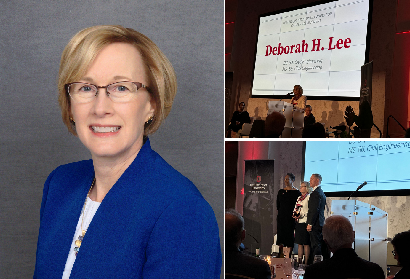
by Gabrielle Farina Comments Off on NOAA GLERL Director receives The Ohio State University Distinguished Alumni Award for Career Achievement
On October 25th, NOAA GLERL Director Deborah Lee received The Ohio State University’s Distinguished Alumni Award for Career Achievement! This award recognizes alumni for significant achievement in business or institutional leadership and professional accomplishments.
Over Deborah Lee’s 39-year career with the U.S. Army Corps of Engineers (USACE) and the National Oceanic and Atmospheric Administration (NOAA), she has driven innovative federal water resources management and research, preserving vital infrastructure, preventing billions of dollars in flood damages, protecting drinking water for millions of people, preventing invasive species, and restoring, connecting and conserving lands and waters. She has also fostered new environmental prediction services and led the way for women and underrepresented and disadvantaged people in science and engineering.
Her eminence in the field of water resources has not only been well-employed within NOAA and USACE, but she has been sought out for binational transboundary water issues with Canada and the International Joint Commission (IJC) and leadership within the American Society of Civil Engineers (ASCE), a global organization representing the civil engineering profession.
Lee was nominated for this award by Eminence to the American Academy of Water Resources Engineers and designated a Fellow of the ASCE. Her numerous recognitions include the ASCE President’s Medal, the Environmental Water Resources Institute’s Lifetime Achievement Award and three Army Superior Civilian Service Awards. She is a registered professional engineer in Ohio and Michigan, and a member of the federal Senior Executive Service. Lee earned her bachelor’s (’84) and master’s (’86) in civil engineering from Ohio State.
Thank you for all you’ve done for water resources management, Director Lee, and congratulations on this well-deserved recognition!
September 10, 2024
by Gabrielle Farina Comments Off on Video: 50 Years of Science in Service to Society at NOAA’s Great Lakes Environmental Research Laboratory
Throughout 2024, NOAA’s Great Lakes Environmental Research Laboratory (GLERL) is celebrating 50 years of science in service to society in the Great Lakes. Our new 50th Anniversary video highlights how GLERL has played a critical role in understanding and protecting Great Lakes ecosystems and communities over the last half-century, and looks ahead to a bright future of innovative science.
Fifty years ago, the National Oceanic and Atmospheric Administration established the Great Lakes Environmental Research Laboratory—GLERL. Tracing its beginnings to 1841 with the formation of the United States Lake Survey, the lineage of the laboratory began with the charting of lakes, and evolved into what is today the epicenter of freshwater research.
Our focus is the Great Lakes, while our relevance spans the country and the globe. This history allowed GLERL to lead the charge in freshwater research, with now more than 120 staff and partners within three major research branches. The voyage has not been easy. Often eyed for budget cuts, the lab has faced the possibility of elimination more than once.
Then the discovery of something small, barely larger than a pencil eraser, began to dramatically alter the Great Lakes ecosystem. The mighty invasive zebra mussel would begin its takeover of the lakes in the 1980s, and it brought with it a renewed focus on GLERL, as well as much needed funding, which would galvanize the importance of the lab in a changing Great Lakes ecosystem.
Even then, the journey was just getting started. During the past five decades, GLERL’s pioneering freshwater research has contributed immensely to our understanding of aquatic ecosystems. In developing and testing technology assets and models, we can better measure and predict environmental parameters. We’ve put our finger on the pulse of the Lakes, capturing the dynamic pressures and systems driving change—changes in our climate, and changes in the Lakes. From shrinking annual ice cover to dramatic changes in lake levels, our predictions are relied upon for public safety, community planning, assessing risks to infrastructure, or threats to our way of life.
[GLERL Research Physical Scientist Steve Ruberg] “GLERL’s mission is connected to really understanding what’s happening with this giant Great Lakes ecosystem. To do that, we have to observe things like the physical properties, like temperatures, the waves, the currents, but also looking at the ecosystem parameters around the chemistry and the biology. And we’re very successful at doing that.”
Some of that data and research is helping communities understand complex environmental concerns and threats to drinking water, like our work with numerous partners to understand and address harmful algal blooms.
[GLERL Research Ecologist Dr. Reagan Errera] “Getting an idea of how the bloom develops, what factors are related to not only the toxicity of the bloom, but the bloom as a whole, really gives us an idea of how we can affect and help with human health.”
[Scott Moegling, Water Quality Manager of Cleveland Water] “They’ve provided a lot of research insight, and these partnerships are really beginning to blossom. By getting advanced warning, we can effectively change our treatment strategies to address the water quality that we’re going to see. That’s important.”
We now go beyond research, having emerged as the regional center for NOAA’s expanding presence in the Great Lakes. As we look to the future, GLERL’s role in the Great Lakes cannot be overstated. With greater and better granularity, we can see changes happening now and on the horizon.
And with our collaborative, creative and passionate team, we will continue to be at the forefront of environmental science, service and stewardship in the 21st century. Here’s to 50 years of scientific excellence and to many more years of discovery. As we forge ahead into an uncertain future, our work will continue to inform responsible resource use and effective management decisions, making communities safer and ecosystems more resilient.
Here at GLERL, we see a future where the Great Lakes continue to be a source of life, beauty, and inspiration for generations to come. NOAA’s Great Lakes Environmental Research Laboratory—protecting our freshwater future.
August 30, 2024
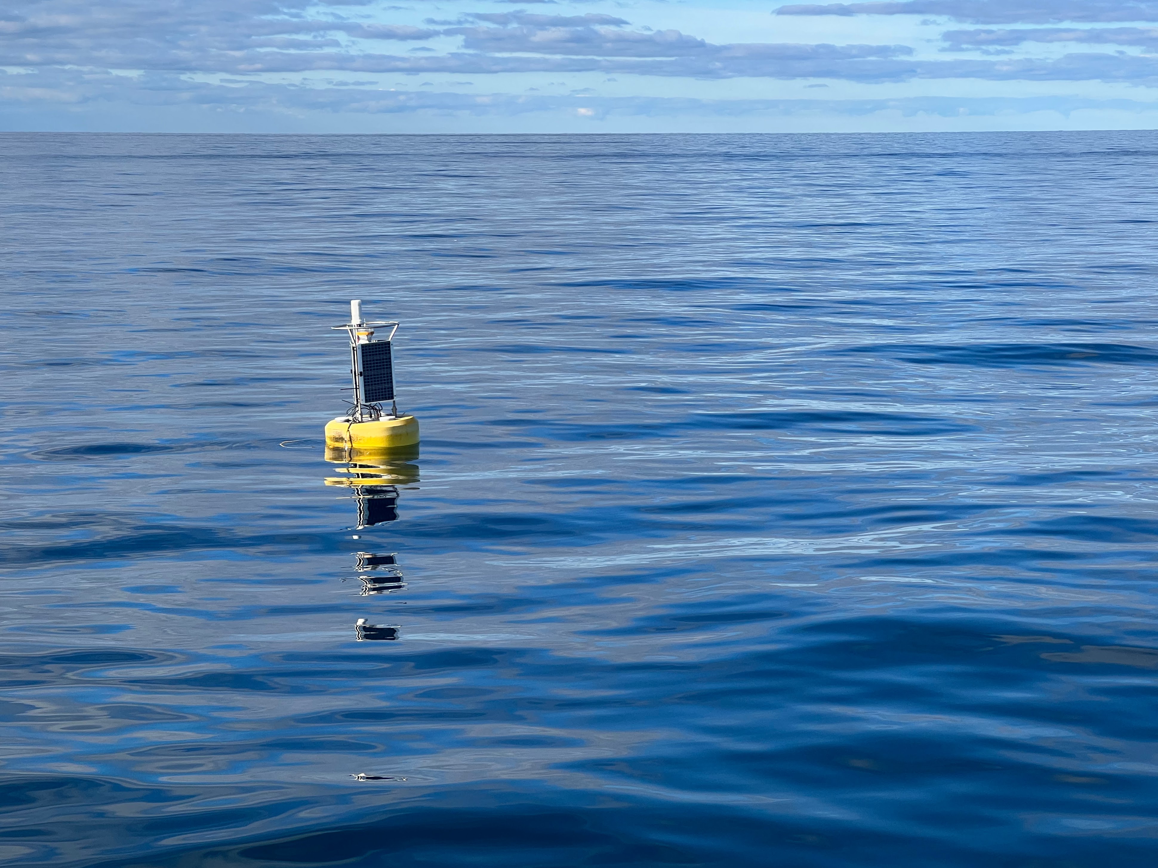
by Gabrielle Farina Comments Off on New buoy is detecting meteotsunamis in the Great Lakes
A new buoy floats in Lake Michigan with the mission monitoring lake conditions to warn the community of meteotsunamis – waves caused by sudden atmospheric pressure changes.
People love the expansive shorelines of the Great Lakes, and will often hit the beach on a warm summer afternoon to swim, play and cool off. But scientists have recently discovered that meteotsunamis – waves caused by sudden atmospheric pressure changes – can sometimes strike lake shores. These waves can hit even in seemingly fair weather, causing dangerous swimming conditions and occasionally damage property and shoreline infrastructure.
In order to better understand these waves and the conditions in which they may develop, scientists at NOAA’s Great Lakes Environmental Research Laboratory (GLERL) have begun monitoring lake waters with a new experimental buoy, originally designed to warn populations around the Pacific Ocean to the threat of seismic, or earthquake-induced tsunami waves. This experimental buoy, outfitted with sophisticated sensors, was first deployed in Lake Michigan during 2021.
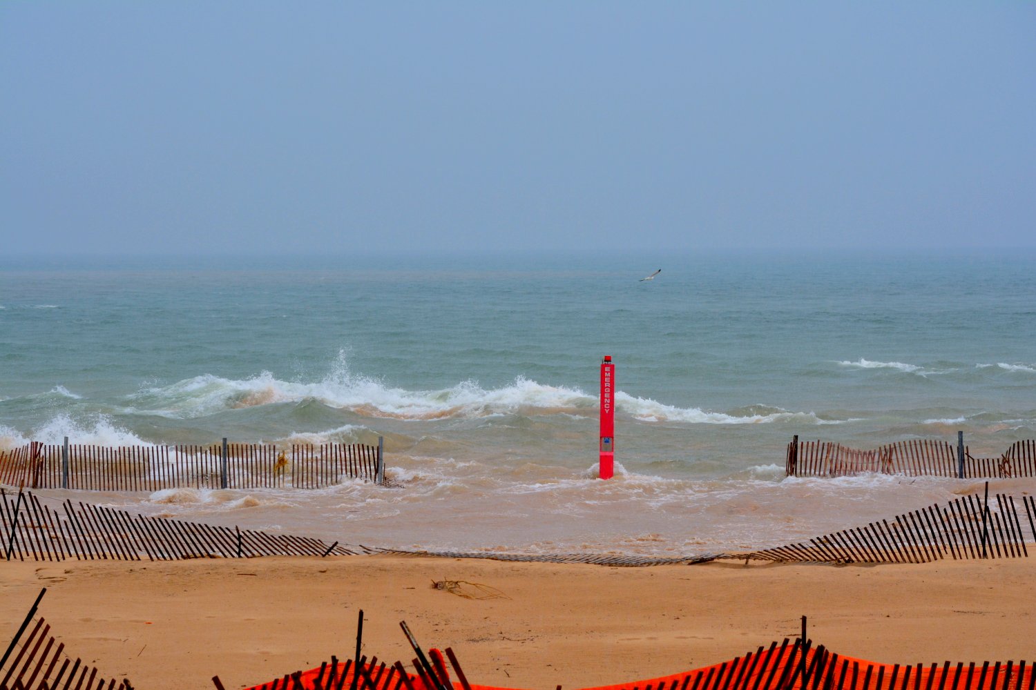
The research work began in 2018, after one of these waves surged onto the beach of Lake Michigan near Ludington, Michigan, damaging homes and boat docks on an afternoon when large destructive waves should not have been present.
High water conditions flood a beach emergency phone during the Lake Michigan meteotsunami event near Ludington, MI on April 13, 2018. Photo credit: Debbie Maglothin.
Scientists were later able to use citizen photos and other observational data to determine that the wave was actually a meteotsunami caused by a gravity wave moving across Lake Michigan. This type of wave in the atmosphere is associated with a rapid decrease and then rapid increase in surface pressure. They are part of our atmosphere, but most of the time they can pass through without causing any meaningful disturbances on the surface of the lake. On this particular day the conditions surrounding the gravity wave and the associated pressure changes interacted with the waters of Lake Michigan, resulting in a series of damaging waves.
This computer model animation shows the changes in atmospheric pressure that caused the Lake Michigan meteotsunami on April 13, 2018. Yellow, orange and red represent higher pressure and blue represents lower pressure. Credit: NOAA
The Ludington wave was the first time that experts were able to confirm that a gravity wave was occurring in the Great Lakes.
“This was the first time we were able to successfully reproduce a meteotsunami through modeling, opening the door for enhanced understanding without having to wait for the next dangerous situation to unfold,” says Bryan Mroczka, a GLERL physical scientist and meteorologist.
This animation shows computer simulated meteotsunami waves generated on April 13, 2018 in Lake Michigan. The red colors represent wave crests (increased water level) and blue colors represent wave troughs (decreased water level). These waves were created by a series of atmospheric gravity pressure waves that contained large changes in barometric pressure. Credit: NOAA
These large waves are most often formed from a thunderstorm moving across a lake. Thunderstorms in the right configuration can result in rapid rising and falling of air pressure that influences the water below, as it synchronizes with the water movement on the lake’s surface. Meteotsunamis are a “Goldilocks” type of event, everything has to be just right. If the thunderstorm complex and pressure wave are moving too slow or too fast for the particular lake, then a meteotsunami will not form.
“The beaches are one of the Great Lakes’ most loved natural resources,” says Mroczka. “Most people are used to thinking that once the sun comes out, the dangers of a storm have passed. However, these meteotsunami waves can be deadly and destructive, and continue to impact the lakes for hours after the rain and thunder have stopped.”
Not every thunderstorm or atmospheric gravity wave will produce a meteotsunami, but when the right conditions are present for their formation, the risk for beach goers and swimmers can even impact areas hundreds of miles away that did not experience the storm. Meteotsunamis can also increase the threat of dangerous rip currents for several hours after the initial waves.
The documentation of the 2018 wave spurred discussions between GLERL’s scientists and those doing tsunami deduction research at NOAA’s Pacific Marine Environmental Lab, and a new tsunami buoy was deployed in central Lake Michigan. This year, GLERL took over ownership of the instrument, which is now recording information that had not been officially observed in real time before.
The buoy is anchored to the floor of Lake Michigan, and monitors water levels to look for anomalies that suggest a meteotsunami is passing. The new data may eventually provide NOAA GLERL the ability to detect and possibly anticipate when one of these dangerous waves will hit the shores in near real-time. Advanced warning through these buoy observations and experimental modeling efforts could also improve rip current detection and provide better warning systems to improve beach safety.
GLERL engineers prepare the meteotsunami buoy for deployment in 2022.
GLERL scientists emphasize that the buoy is not intended to detect seismic events in the Great Lakes, although its design was somewhat based on other buoys in the Pacific that do detect things like earthquakes. In December of 2021, for example, the buoy recorded an atmospheric pressure wave’s influence on the lake water level as it circled the globe after the eruption of Hunga Tonga. Although this volcanic pressure wave was moving too fast to result in any unusual waves in the Great Lakes, it does show the variety of atmospheric phenomena that can potentially be triggers for meteotsunamis under the right circumstances.
While the 2018 Ludington wave was documented by modern photography, history reveals news stories of large waves from the past that were likely the result of meteotsunamis. On July 4, 1929 a large wave reportedly killed 10 people who were swept off a pier in Grand Haven, Michigan by a large wave following a morning thunderstorm. And in June 1954, a famous “freak wave” was described by eyewitnesses along the Chicago lakeshore before it killed 8 people. That particular wave was recorded just after the same weather pattern – a very strong thunderstorm was followed by beautiful clear weather. More recently, another July 4 storm hit Warren Dunes State Park in Michigan in 2003, causing a meteotsunami and killing seven swimmers caught in the resulting rip currents that formed after the wave had passed. All these waves were likely also meteotsunamis.
“It is exciting to get new information about our lake systems, and this buoy provides a whole new way to look at how the weather impacts the waters of the Great Lakes and our beaches,” says Mroczka. “Our goal is to understand the dynamics of these events better so that people can keep enjoying the lakes without worrying about meteotsunamis.”
August 5, 2024
by Gabrielle Farina Comments Off on Why NOAA GLERL’s largest vessel is one of its most critical research tools
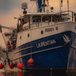
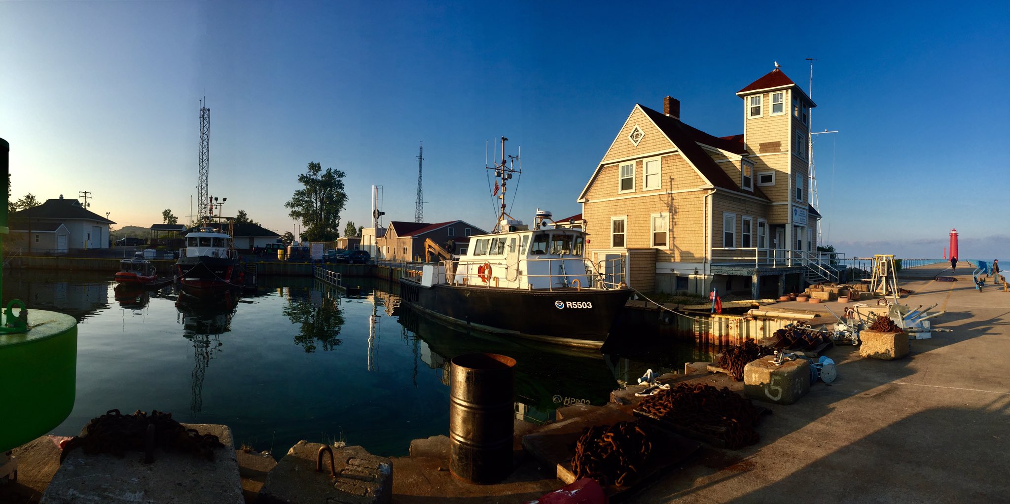
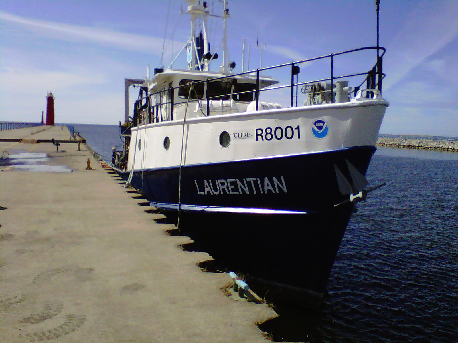
Throughout 2024, NOAA’s Great Lakes Environmental Research Laboratory (GLERL) is proudly celebrating its 50th anniversary. But in addition to celebrating our own birthday, GLERL shares its anniversary with one of our most important assets – the R/V Laurentian. Added to our research fleet in 2002, the 80-foot Laurentian is GLERL’s largest vessel, and has many unique features that make it a fundamental component of our Great Lakes science. The Laurentian is based out of GLERL’s Lake Michigan Field Station in Muskegon, MI, and is a critical resource for GLERL – without which much of our science could not be accomplished.
The Laurentian was built for the University of Michigan in 1974, who operated it as a University National Oceanographic Laboratory System for the next 28 years. GLERL began leasing it from the University in 2002 and purchased it in 2017. This vessel is an incredibly versatile platform for GLERL’s ecological sampling, fisheries surveys, and deployments of advanced observing systems. There is extensive deck machinery, laboratory space, and onboard accommodations that can be adapted for various projects.
Early photo of the Laurentian. Credit: R. Stephen Schneider via the University of Michigan.
Not too big, not too small
At 80 feet long, the Laurentian’s size gives it some advantages of both larger and smaller vessels. A larger boat, such as the EPA’s 180-foot Lake Guardian, would require more people to operate, resulting in less flexibility with scheduling and weather delays. On the flipside, a smaller boat like GLERL’s 50-foot Storm would have more space limitations and less tolerance for wavy conditions. The Laurentian’s moderate size means it can be operated with as little as two crew on board, while still being large enough to handle rougher days on the lake.
R/V Laurentian in summer 2006.
“The Laurentian gives us the ability to be flexible and still accomplish the mission,” says NOAA GLERL Fishery Biologist Steve Pothoven, who conducts long-term monitoring and larval fish research on the vessel year-round.
Around the clock, throughout the year
One of the Laurentian’s most useful qualities is its ability to remain in the water year-round, thanks to its durable steel hull. While it doesn’t actively break ice, the Laurentian is the only GLERL vessel that doesn’t need to be removed from the water during the winter months. Its ability to endure Great Lakes winters allows it to be used into December – even January and February if there’s low ice – for crucial winter observations. Much remains to be learned about Great Lakes ecological processes during the winter months due to difficult fieldwork conditions, and the Laurentian’s wintertime capabilities help scientists capture critical ecosystem changes throughout the year.
The Laurentian heads out into Lake Michigan on a frigid February morning.
The Laurentian’s flexibility isn’t just on a seasonal timescale – its ability to support overnight offshore research cruises is another major advantage. One of GLERL’s research areas that benefits from both overnight and winter observations is the observation of Mysis, a small Great Lakes crustacean similar to shrimp. Mysis are an important part of the Great Lakes food web, as they eat phytoplankton and zooplankton and serve as a food source for Great Lakes fish. They are sensitive to light and temperature, staying in deeper waters during daylight to avoid being eaten, and migrating toward the surface at night to feed. GLERL scientists regularly use the Laurentian for offshore, overnight research cruises to study this feeding behavior.
Mysis from Lake Huron viewed under a microscope. Credit: M. Tomczak, CIGLR
Additionally, Mysis breed during the winter, and studying the timing of their breeding cycle helps us understand how climate change is impacting their reproductive capacity. The Laurentian’s larger size makes it a perfect vessel for carrying out both overnight and wintertime cruises to study this important indicator of Great Lakes ecosystem health and balance.
A key element of GLERL’s science
Collage of ecological and observing systems research being conducted on the Laurentian.
Since GLERL’s addition of the Laurentian to its research fleet over 20 years ago, this vessel has been critical in supporting our research efforts. From daily to decadal research timescales, its unmatched versatility supports GLERL’s mission in the Great Lakes every day. The stories and resources below are just a few examples of GLERL’s groundbreaking science that could not be accomplished without a ship of the Laurentian‘s size and capabilities.
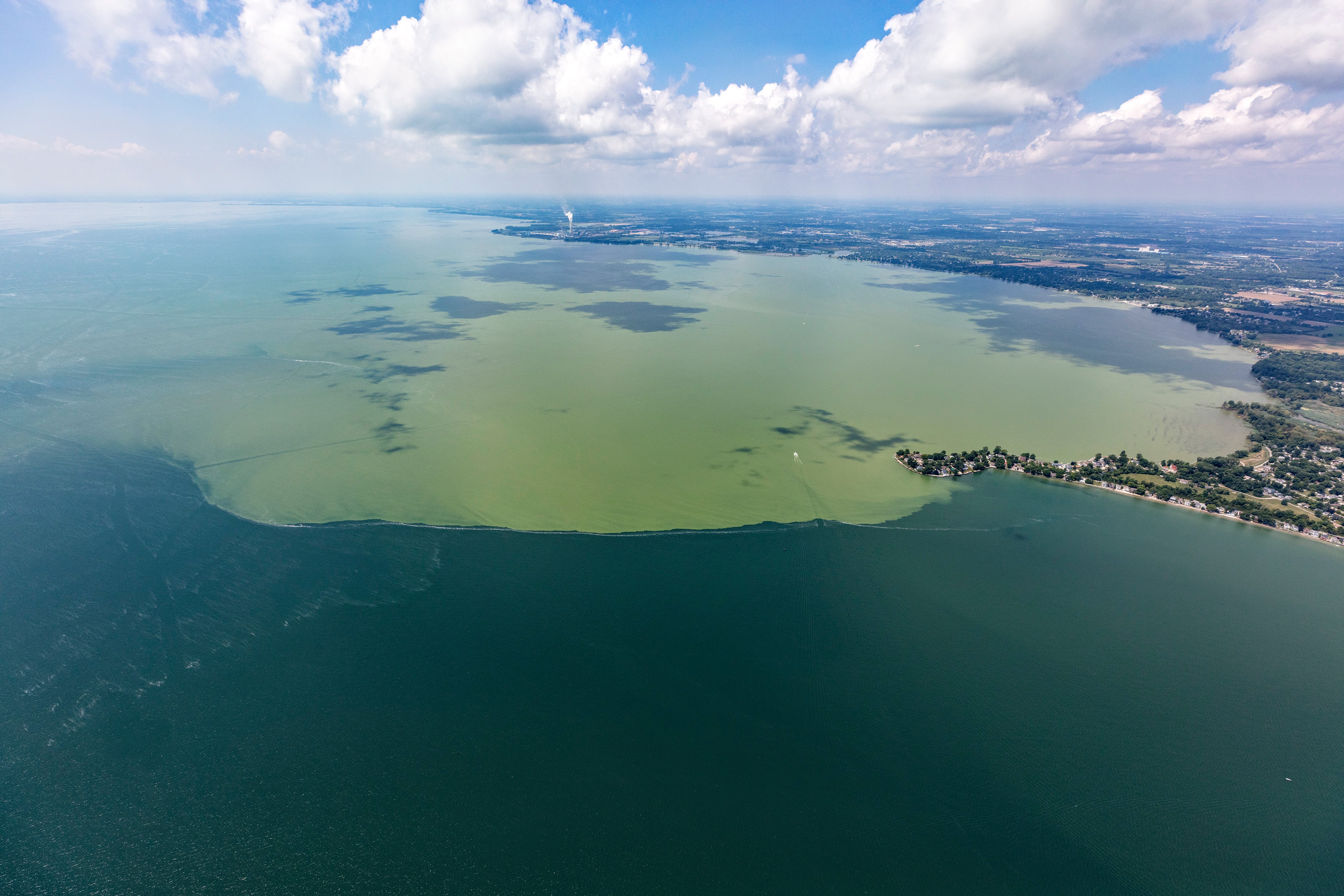
The 2024 harmful algal bloom (HAB) season in the Great Lakes is in full swing – but long before the bloom began, scientists at NOAA GLERL and the Cooperative Institute for Great Lakes Research (CIGLR) had already been preparing for this annual phenomenon for months.
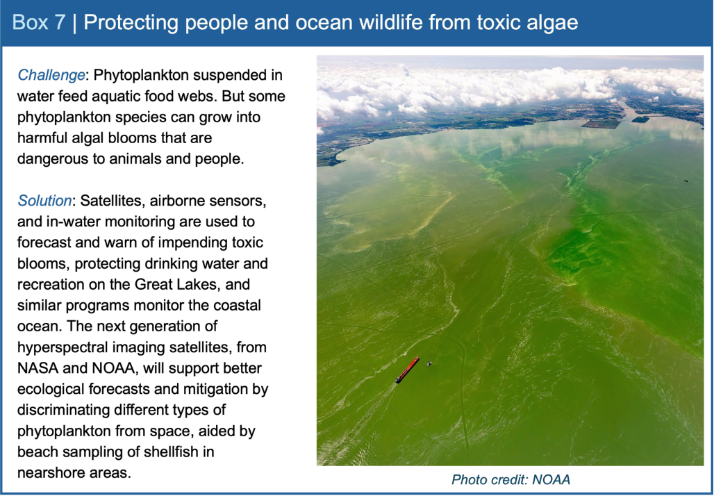
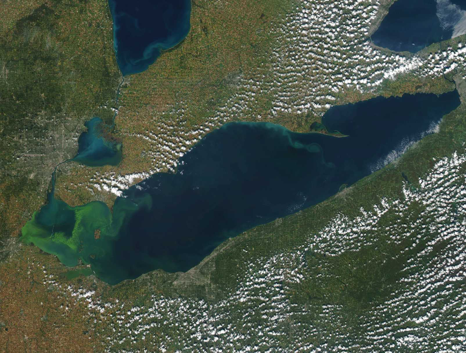
HABs in the Great Lakes occur when algae grow rapidly, forming dense scums and water discoloration. Some blooms can produce neurotoxins, liver toxins, or skin irritants and can be very dangerous to come into contact with. These blooms can contaminate drinking water, harm swimmers and pets in areas where toxins are concentrated, and pose a severe nuisance to recreational and commercial boating and fishing. The decomposition of biomass from HABs can also lead to hypoxia, the occurrence of low or depleted oxygen levels in a water body. Hypoxia is common in Lake Erie’s central basin and can lead to fish kills and pose threats to the drinking water treatment process.
Aerial view of a harmful algal bloom in western Lake Erie
The NOAA Great Lakes HABs and Hypoxia program is a collaborative effort between GLERL and CIGLR scientists. This integrative research approach includes using various observing systems, weekly monitoring cruises, and advanced genetic techniques to understand the long and short-term seasonal dynamics of HABs and hypoxia. The data collected are used to inform forecast models used by key Great Lakes stakeholder groups, such as drinking water managers and fisheries managers.
GLERL and CIGLR’s comprehensive monitoring program in Lake Erie and Saginaw Bay (Lake Huron) is a core element of our ongoing HAB research. Field samples are collected weekly at eight sampling sites across western Lake Erie and biweekly at ten sites in Saginaw Bay. Buoys also collect data continuously throughout the season. Planning and conducting this monitoring work is no small task and calls for all hands on deck both in the field and in the laboratory.
HAB sampling stations in western Lake Erie (left) and Lake Huron’s Saginaw Bay (right)
Behind the scenes, before the HAB
Preparations for the 2024 HAB season began last December, when the HAB team began its intensive cleaning process in the lab. In order for the team to accurately analyze lakewater samples starting in the spring, their lab equipment needs to be extremely clean – even cleaner than it comes from the manufacturer. Bottles, vials, filters, and tubes all need to be washed with acid to ensure that no residue will contaminate the water samples brought back from the field. Throughout this past winter and spring, the team was responsible for prepping and cleaning roughly 5,350 individual pieces of lab equipment!
Laboratory sampling stations like this one are prepped for scientists to process water samples from Lake Erie and Saginaw Bay.
Winter and early spring are also the time for calibrating the high-tech equipment that GLERL and CIGLR use to monitor HABs in the field. A conductivity, temperature, depth device, or CTD, is one of these primary pieces of equipment. A CTD’s primary function is to detect how the conductivity and temperature of the water column changes relative to depth. Conductivity is a measure of how well a solution conducts electricity and it is directly related to salinity. Even though the Great Lakes are freshwater, the salinity component of a CTD still helps us study the water chemistry of the lake. Sensors for photosynthetically active radiation (PAR) and dissolved oxygen are also mounted to our CTD instruments, so that light and oxygen levels in the water can also be measured.
Another key instrument that needs pre-season calibration is the FluoroProbe. Out in the field, the FluoroProbe helps scientists look at how different groups of phytoplankton – the microscopic organisms that make up the algal blooms – are distributed vertically throughout the water column and at different locations in the lake. Back at the lab, the FluoroProbe is used again on water samples from known depths in the lake to double check that the field measurements are accurate.
Timelapse of a FluoroProbe instrument analyzing water samples for different groups of phytoplankton.
Ramping up for HAB season with weekly cruises
Once the laboratory is ready and the equipment is calibrated, the HAB crew is ready to begin their weekly monitoring cruises to collect water samples. Cruises began in late April of this year, and are typically conducted through October, depending on the duration of the bloom. With this timeframe, scientists can monitor the water quality before the bloom begins, and then track how its size and toxicity changes throughout the summer. For the 2024 season, 55 HAB-related research cruises are planned, 22 of which are specific to weekly monitoring of the Lake Erie HAB.
Heading out into the western basin of Lake Erie for a weekly HABs sampling cruise in June 2023.
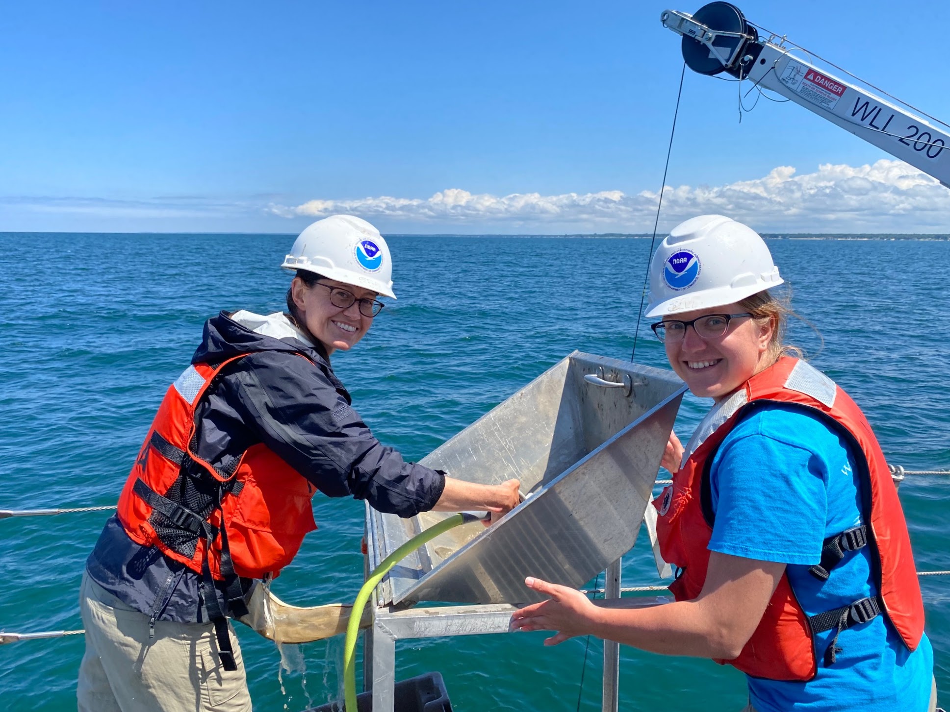
Planning the logistics for each cruise is no small feat. Each weekly monitoring cruise on Lake Erie requires ten people – one boat captain, two field crew members, and seven lab crew members. Cruises are extremely weather-dependent, so day-to-day plans have to remain extremely flexible in order to ensure the crew’s safety as well as the quality of the samples and data collected. A typical cruise day can involve early mornings and late evenings, especially on longer trips like the outer bay stations of Saginaw Bay. The main goals of a weekly sampling cruise involve collecting water samples to bring back to the lab and collecting data with our instrumentation, like the CTD and FluoroProbe.
Once the field crew arrives back at GLERL’s Ann Arbor facility, they immediately pull the data from the CTD and FluoroProbe, and clean all of the equipment for the next cruise. Then, the lab work begins to preserve and analyze that day’s new water samples. Seven people are required for the tasks of dividing up the samples, processing them for all the different parameters that will eventually be analyzed, and either preserving them or starting to analyze them. In total, the water collected on each cruise is analyzed for 30 different parameters, including measurements like turbidity, colored dissolved organic matter, total suspended matter, and microcystins. Photosynthetic pigments, like chlorophyll a and phycocyanin, are extracted and ready to report within days of collection.
Left: CIGLR’s Paris Schofield and Teige O’Brien unload water samples and equipment after a weekly sampling cruise. Right: Paris Schofield unpacks coolers of water samples to be analyzed.
One of the most important parameters the crew measures is the water’s concentration of microcystin, the dominant algal toxin in Lake Erie HABs. This measurement tells us how toxic the bloom is at the location the sample was collected, and allows us to track how the bloom changes throughout the season. Certain measurements of organic carbon in the samples also have to be taken right away, as this aspect of the water’s chemistry can’t be preserved in storage. New data from these cruises are available weekly on NOAA GLERL’s website.
After the higher-priority measurements are done, the HABs team stores the water for more analyses later on. One example is the quantity and variety of phosphorus in the water, which is important for researching the formation of HABs. But because phosphorus is time- and labor-intensive to analyze and is able to be stored, the lab crew will actually freeze these water samples and then measure their phosphorus levels the following winter.
Left: Andrew Camilleri (CIGLR), Reagan Errera (GLERL), and Paris Schofield filter water samples from the field. Right: Nhung Nguyen (CIGLR) preserved dissolved organic carbon samples to be analyzed later on.
A variety of research approaches
While weekly sampling is a vital aspect of GLERL and CIGLR’s HAB research, it goes hand-in-hand with an integrated suite of several other methods. Together, all of these approaches support NOAA’s Lake Erie HAB Forecast and help us gain a more comprehensive understanding of HAB dynamics.
From left to right: GLERL and CIGLR scientists deploy an Environmental Sample Processor; GLERL conducts a hyperspectral flyover of the Lake Erie HAB; a long-range autonomous underwater vehicle; a CIGLR nutrient buoy used to monitor HABs.
The Environmental Sample Processor, or ESP is a “lab in a can” that’s designed for autonomous deployment, meaning it can function on its own without human help once deployed. It collects water samples, measures microcystin, and sends the data back to scientists in near-real time. This toxicity data produced by ESPs helps provide water managers with more precise bloom location, projected direction, intensity, and toxicity.
Remote sensing with hyperspectral cameras allows scientists to study what types of algae are in harmful algal blooms. Hyperspectral cameras capture more bands of discrete wavelengths than normal cameras. To conduct this research, a small plane equipped with the camera is flown over the bloom area.
Autonomous underwater vehicles (AUVs) and autonomous surface vehicles (ASVs) are useful research tools that can collect high-quality data more efficiently and cost-effectively than scientists taking samples from a ship or along the shore. These vehicles are often equipped with a smaller, more mobile version of the ESP in order to track and analyze the toxicity of the bloom.
‘Omics, a growing science and technology focus area, employs fields such as metagenomics, metatranscriptomics, and proteomics to examine genetic material (DNA, RNA and proteins) from an array of species. ‘Omics data has become increasingly valuable in understanding and addressing issues related to Great Lakes HABs, including factors influencing the production of the microcystin toxin.
Buoys with sensors that measure physical and chemical parameters in the lake provide a continuous source of real-time HAB data throughout the season. Data is available on NOAA GLERL’s website for Lake Erie and Saginaw Bay.
For more information on NOAA GLERL and CIGLR’s HAB research, visit our HABs and Hypoxia page.
June 14, 2024
by Gabrielle Farina Comments Off on GLERL scientist represents NOAA and the Great Lakes on new National Ocean Biodiversity Strategy
On June 3, the White House announced the release of the National Ocean Biodiversity Strategy, which will expand and use biodiversity information to help protect and conserve marine and Great Lakes ecosystems and maximize their benefits to people. This strategy aims to understand and restore life of the oceans and Great Lakes, which provide food, clean air and water, climate regulation, and cultural identity.
Andrea Vander Woude, NOAA GLERL’s Integrated Physical and Ecological Modeling and Forecasting Branch Chief, was on the team that developed the strategy and will continue to be involved and provide services to the Great Lakes.
This work will advance standards and best practices for interoperable, widely accessible biodiversity data; integrating satellite data products with in situ observations of ocean biodiversity to understand the distribution and abundance of organisms and the integrity of ecosystems; and expanding collection of ocean biodiversity information across all realms, including the coasts, deep sea, and the Great Lakes.
This highlight from the Strategy addresses NOAA’s work to research and forecast harmful algal blooms (HABs) in the Great Lakes to protect the region’s drinking water and recreation.
May 29, 2024
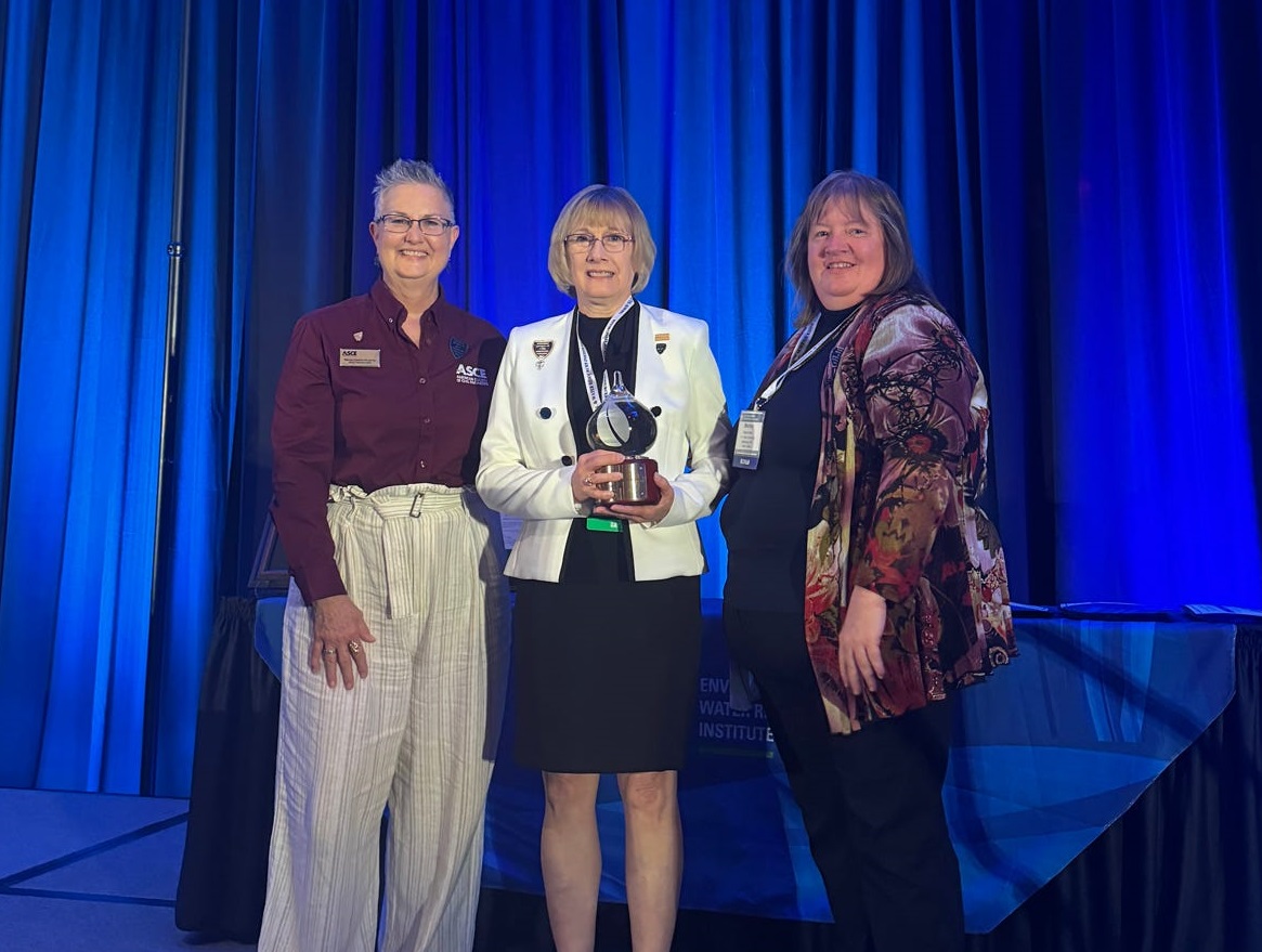
by GLERL Communications Team Comments Off on GLERL director Deborah Lee receives Lifetime Achievement Award from the Environmental & Water Resources Institute of the American Society of Civil Engineers
With Internationally-recognized expertise in water resource management, Ms. Lee has distinguished herself as a registered professional engineer, professional hydrologist, and fellow of the American Society of Civil Engineering (ASCE). Ms. Lee’s D.WRE board certification is the highest, advanced certification for professional engineers dedicated to the water resource engineering profession.
“I am honored by this recognition from my peers in the water resources professional community,” says Lee. “Applying my profession in the service of our country through my current work with NOAA and previous experience with the Army Corps of Engineers is important to our country and communities as we work to solve our future water challenges.”
The award was presented in May at the 2024 World Environmental & Water Resources Congress taking place in Milwaukee, Wisconsin. Created in 1999, the EWRI is the leader within the ASCE for the integration of technical expertise and public policy in the planning, design, construction, and operation of environmentally sound and sustainable infrastructure impacting air, land and water resources.
Throughout her career, Lee has been a leader in the field of civil engineering, often bridging the communications and knowledge gaps between the natural resource research fields and the science of engineering. She served on the Governing Board of the Environmental Water and Resources Institute (EWRI), part of the ASCE, from 2019 through 2022, and served as the EWRI President in 2020-2021. She championed NOAA working with EWRI and other ASCE Institutes to consider a changing climate in codes, standards, and manuals of practice. She was recognized with the ASCE President’s Award in 2022 for her efforts.
NOAA GLERL and its partners conduct innovative research on the dynamic environments and ecosystems of the Great Lakes and coastal regions to provide information for resource use and management decisions that lead to safe and sustainable ecosystems, ecosystem services, and human communities.
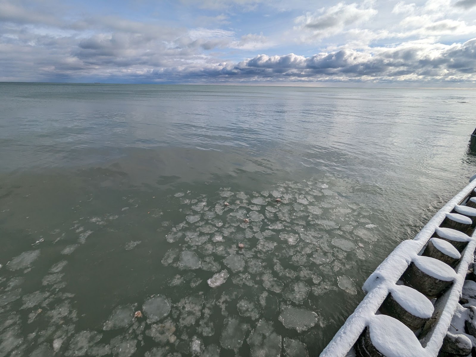
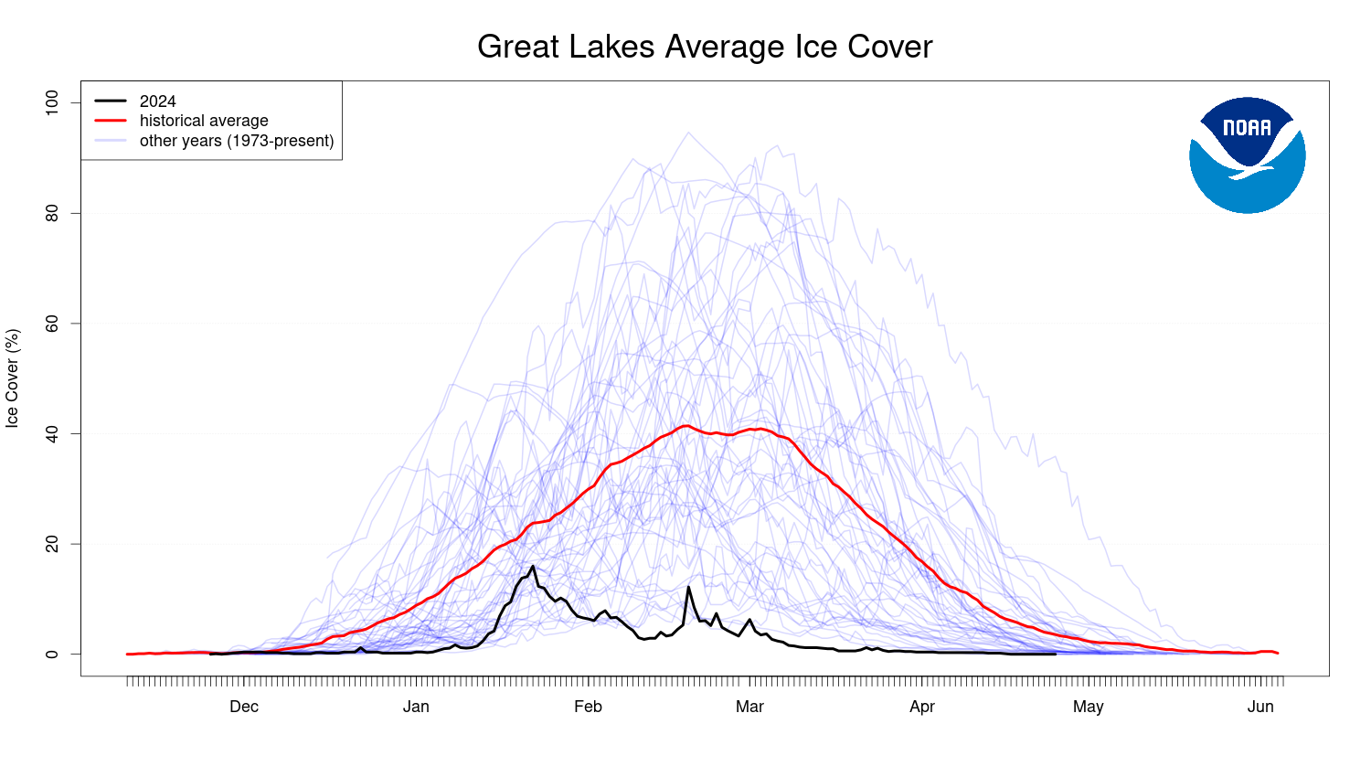
While it feels like winter in the Great Lakes is long gone, the official ice season for the lakes has just recently concluded. The northernmost regions of Lake Superior often have lake ice throughout April, even during particularly mild winters like 2023-2024. This year, Great Lakes ice cover officially hit 0.0% on April 20th.
Pancake ice in Lake Huron in January, 2024.
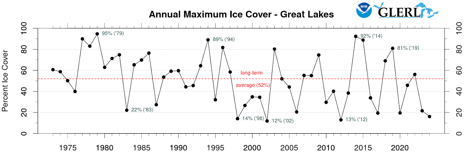
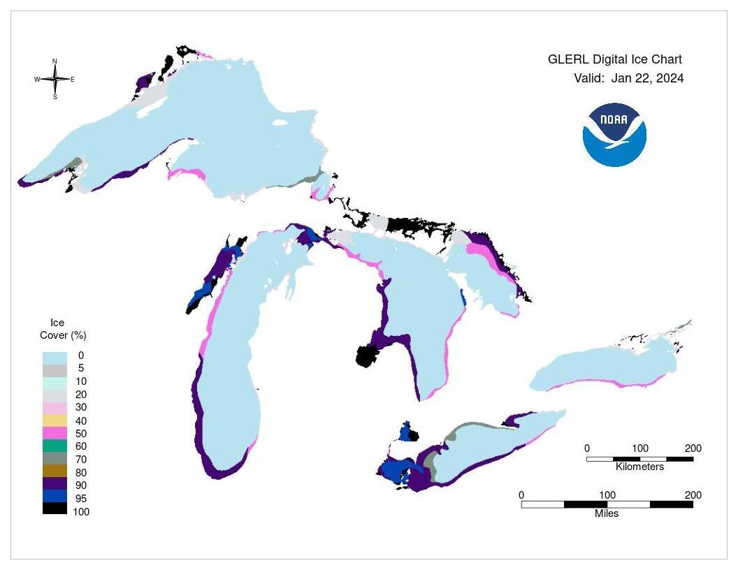
This year’s average ice cover for the Great Lakes as a whole was 4.3%, an official record low since records began in 1973. Annual maximum ice cover reached 16% on January 22, coming in as the fourth lowest annual maximum on record.
Great Lakes annual maximum ice cover from 1973-2024.
Great Lakes average ice cover for 2024 compared to past years and the historical average (1973-2023).
Ice conditions on January 22, 2024, the day with maximum ice cover this season.
Lake by lake stats
Lakes Superior, Huron and Michigan all had record-low seasonal averages, and Lake Huron had a record-low annual maximum ice cover as well. Check out each lake’s summary below.
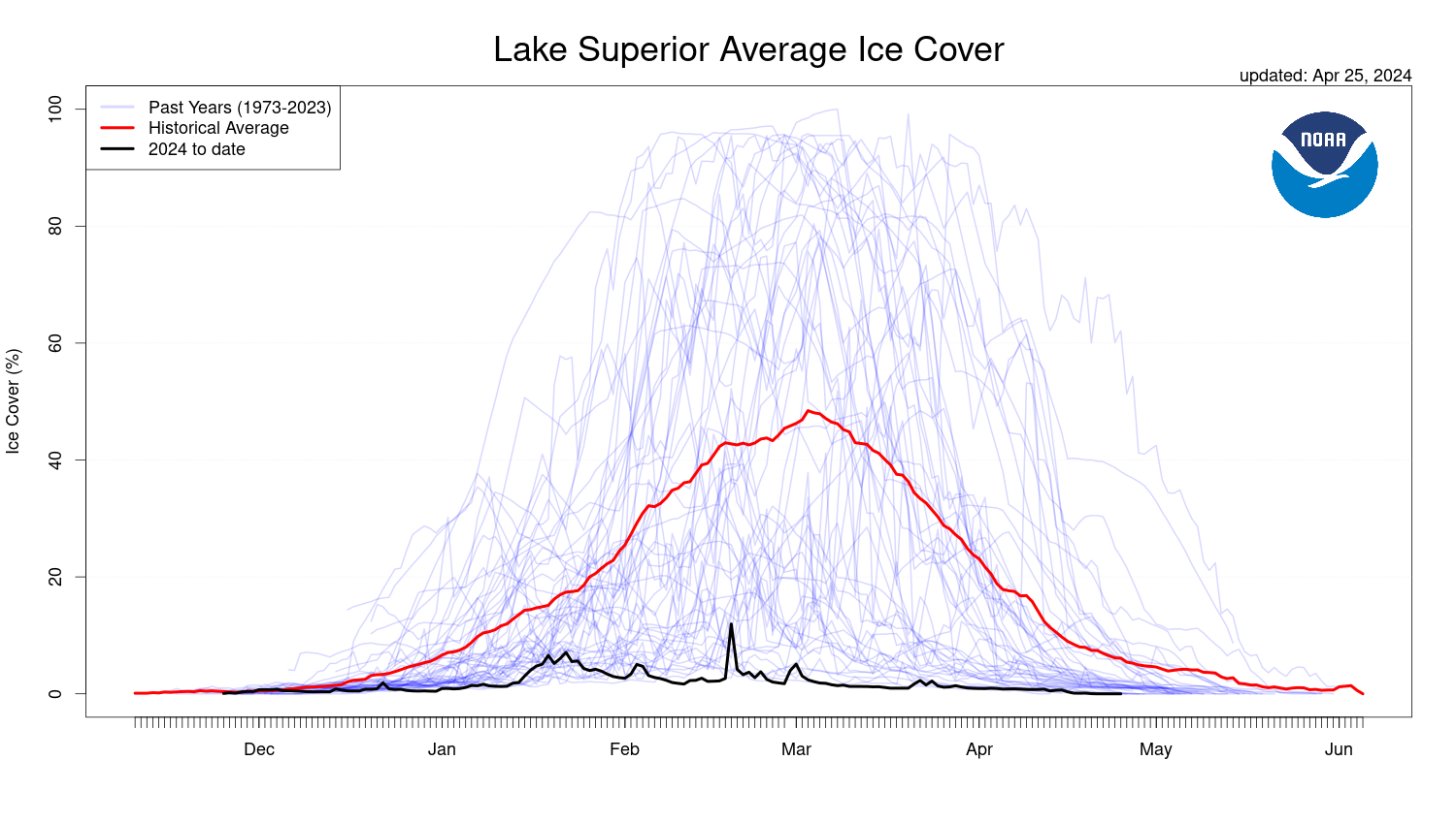
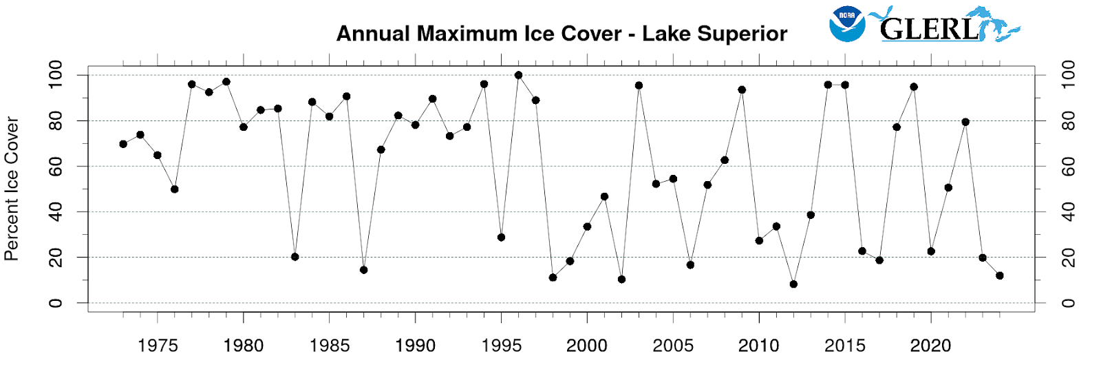
Lake Superior’s seasonal average was a record low at 2.6%. Superior reached maximum ice cover at 12% on February 19, which is the fourth lowest maximum on record since 1973. However, this lake would have set a record low if not for a cold snap that brought its ice from 2.6% to 12% in a single day.
Lake Superior average ice cover for 2024 compared to past years and the historical average (1973-2023).
Lake Superior annual maximum ice cover from 1973-2024.
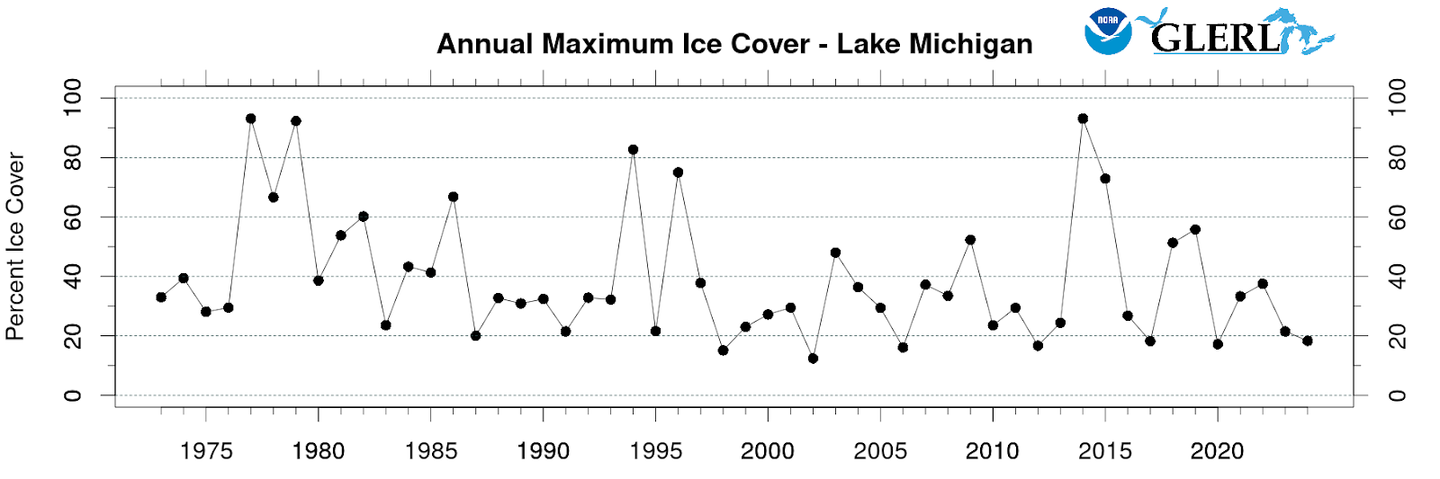
Lake Michigan also experienced a record-low seasonal average at 4.4%. Its annual maximum was 18.3%, ranking as the seventh lowest on record.
Lake Michigan average ice cover for 2024 compared to past years and the historical average (1973-2023).
Lake Michigan annual maximum ice cover from 1973-2024.
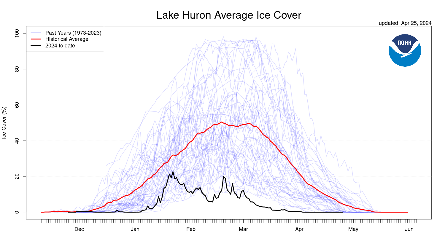
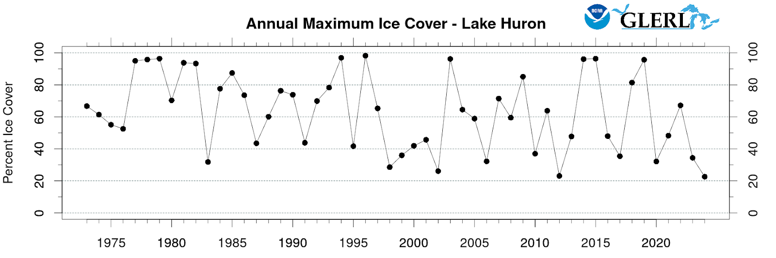
Lake Huron is the only lake to have set a double low record in 2024, with a seasonal average of 7.8% and an annual maximum of 22.7%.
Lake Huron average ice cover for 2024 compared to past years and the historical average (1973-2023).
Lake Huron annual maximum ice cover from 1973-2024.
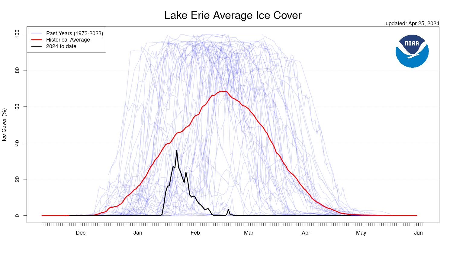
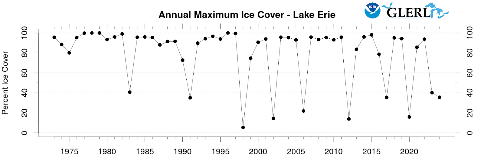
As the shallowest of the five Great Lakes, Lake Erie often sees higher ice cover than the other lakes. This year, Erie’s seasonal ice cover averaged at 4.3%. Its annual maximum was 35.7%, which ranks as the eight lowest on record.
Lake Erie average ice cover for 2024 compared to past years and the historical average (1973-2023).
Lake Erie annual maximum ice cover from 1973-2024.
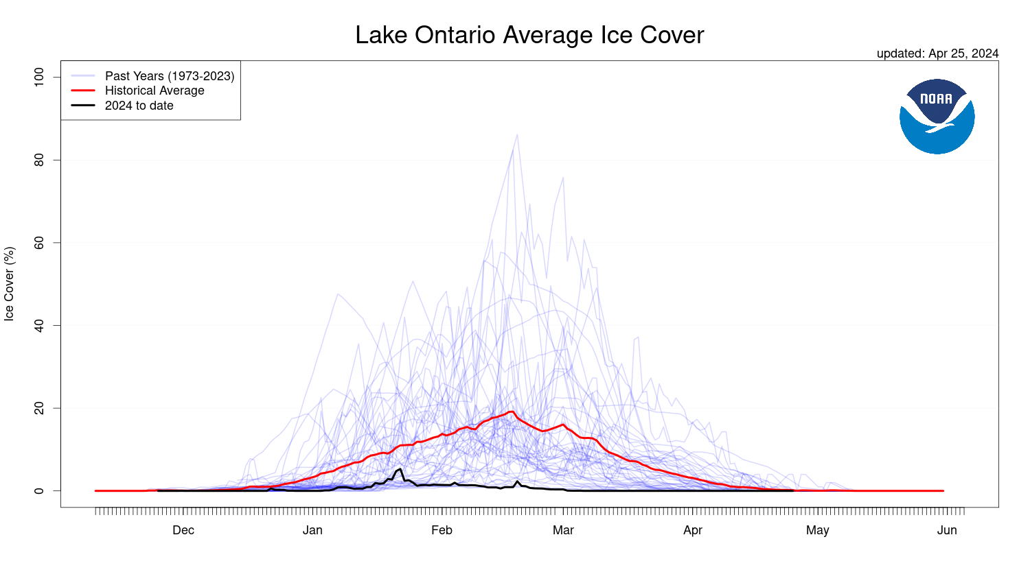
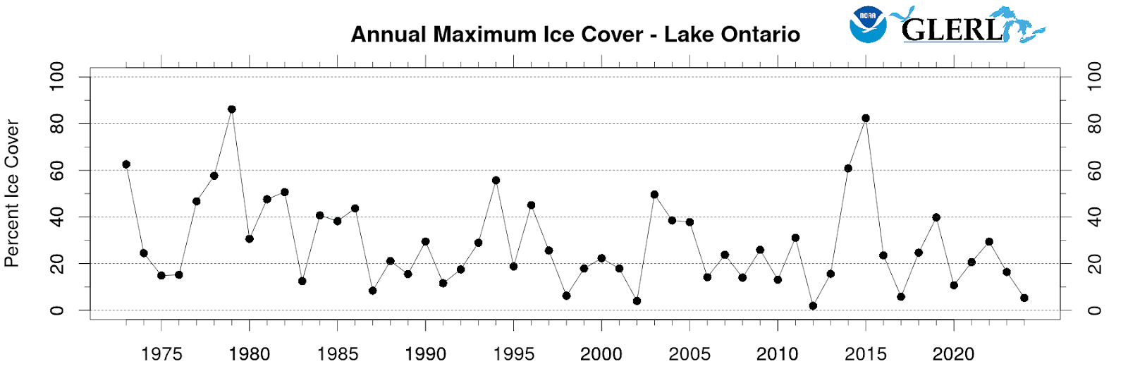
Lake Ontario didn’t quite set any records this year, but its seasonal average was the second lowest on record at 0.8%. Ontario’s annual maximum ice cover was the third lowest on record, reaching 5.3%.
Lake Ontario average ice cover for 2024 compared to past years and the historical average (1973-2023).
Lake Ontario annual maximum ice cover from 1973-2024.
May 7, 2024
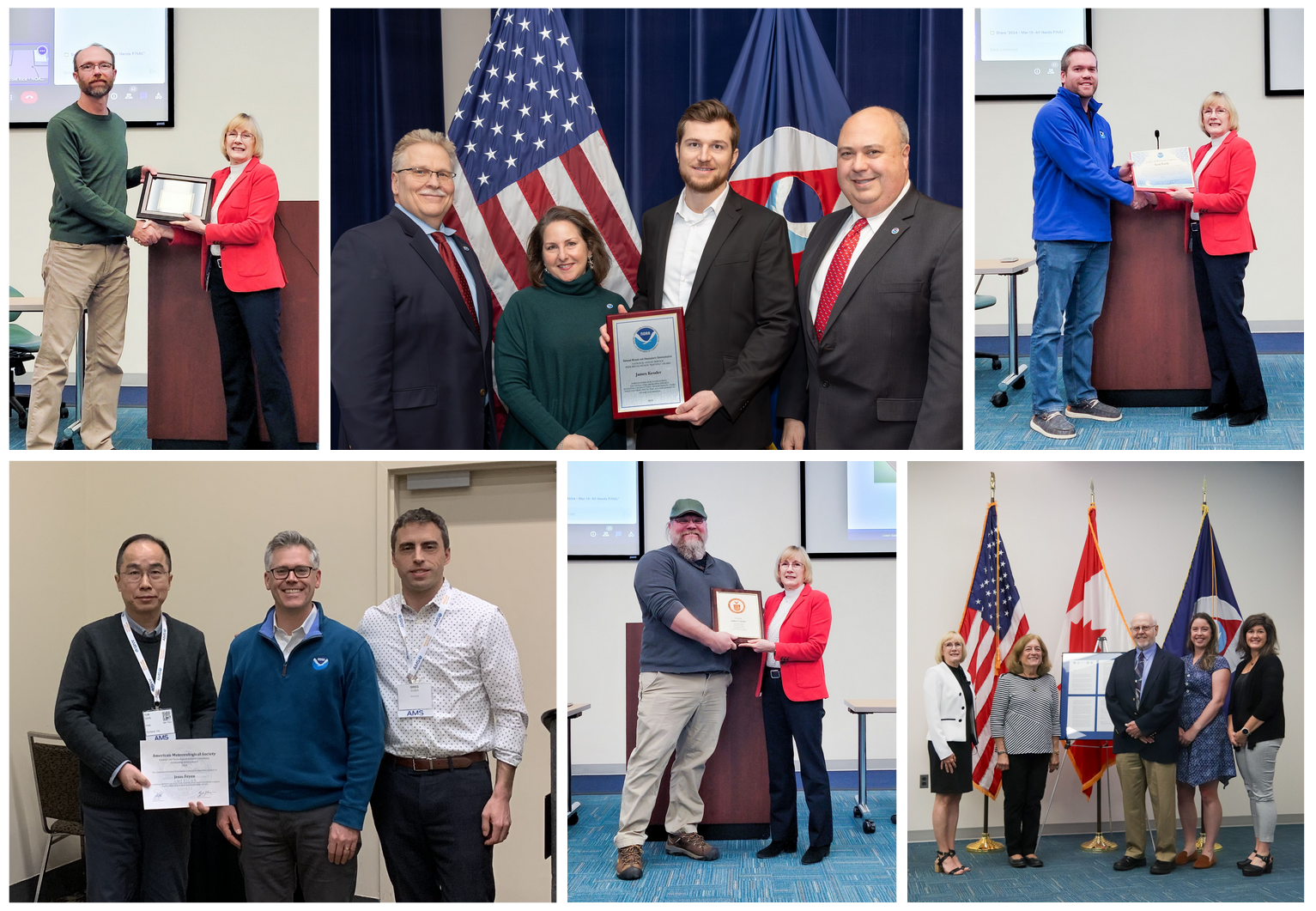
by Gabrielle Farina Comments Off on Award-winning science and service: Celebrating Public Service Recognition Week during GLERL’s 50th year
This year, NOAA’s Great Lakes Environmental Research Laboratory (GLERL) celebrates its 50th anniversary. In addition to celebrating 50 years of our Great Lakes science for society, we’re also celebrating Public Service Recognition Week from May 5-11.
NOAA GLERL’s workforce is made up of passionate and dedicated public servants, and many GLERL staff are recognized each year for their outstanding contributions to the world of Great Lakes science. Check out our recent awards and recognitions below!
GLERL Director Deborah Lee – credentialed as an Envision Sustainability Professional by the Institute for Sustainable Infrastructure. She is the first NOAA employee to do so, and joins a group of more than 3400 engineering professionals nationwide with this credential. Read more
GLERL Deputy Director Jesse Feyen – American Meteorological Society’s Scientific and Technological Activities Commission (STAC) 2023 Committee on Coastal Environment Outstanding Service Award. Read more
Mark Rowe – Department of Commerce Bronze Award: For leadership in developing the Ocean, Coastal, and Great Lakes Acidification 2020-2029 Research Plan. The highest honor award granted by the Under Secretary of Commerce for Oceans and Atmosphere for superior performance.
James Kessler – NOAA Ocean Service Peer Recognition Award for outstanding performance while collaborating with the NOAA Office of Response and Restoration and the U.S. Coast Guard in 2022 and 2023. Read more
Scott Purdy – NOAA Silver Sherman Award for outstanding service as GLERL’s Human Resources Coordinator.
Steve Constant – Recognized for 15 years of Federal Service.
David Reid (retired) – Recognized for career achievements in reducing Great Lakes aquatic invasive species introductions. Read more
NOAA GLERL is one of ten Federal research laboratories in the Oceanic and Atmospheric Research line office of NOAA. Designated on April 25, 1974, GLERL was established to provide a focus for NOAA’s environmental and ecosystem research in the Laurentian Great Lakes. The original GLERL was formed by merging staff from the Limnology and Computer Divisions of the Lake Survey Center of NOAA’s National Ocean Service with the staff of the International Field Year for the Great Lakes Office.
GLERL has made many important scientific contributions to the understanding and management of the Great Lakes and other coastal ecosystems. GLERL scientists regularly engage with academic, state, federal, and international partners. GLERL research provides information and services to support decisions that affect the environment, recreation, public health and safety, and the economy of the Great Lakes and coastal marine environments.
The Early Years
Algal blooms caused by excess nutrients were one of the major environmental issues in the 1970s, and a GLERL-developed phosphorus model was used by the International Joint Commission to determine loading limits. By 1980, the laboratory had expanded to include a major research effort on the cycling of sediment particles and associated toxic organics, which were recognized in the Great Lakes Water Quality Agreement as a major environmental problem. GLERL scientists led some of the early work in identifying and evaluating processes affecting the deposition and cycling of contaminants in the lakes. This work showed that the sediment zone is a major repository for contaminants and also a major source for recycling contaminants to the water column and food web. A Great Lakes oil spill model was put into operational use and successfully predicted the drift of an abandoned ship.
Aerial view of a harmful algal bloom on Lake Erie.
GLERL staff worked cooperatively with other agencies to develop research projects focused on major environmental issues in keeping with NOAA’s mission and goals. GLERL’s water resources research focus was expanded to include the impacts of climate change on the Great Lakes, which has led to GLERL’s participation in the national Water Resources Forecasting Program. GLERL’s scientific expertise on the movement and cycling of sediment particles, and circulation measurements and modeling, has led to several large joint research programs with the U.S. Environmental Protection Agency to develop contaminant mass balance models for selected areas: the Upper Great Lakes connecting channels, Green Bay, and Lake Michigan. Also during this time, microcinematography was used to understand zooplankton behavior and predation.
1980s
Facilities and the Cooperative Institute for Great Lakes Research
In 1987, GLERL moved to a new facility in northeast Ann Arbor. This permitted consolidation of laboratories and marine instrumentation space for the first time. The Cooperative Institute for Limnology and Ecosystems Research (CILER), now known as the Cooperative Institute for Great Lakes Research (CIGLR), was established in 1989 in an agreement between NOAA, the University of Michigan, and Michigan State University.
Research on Invasive Species
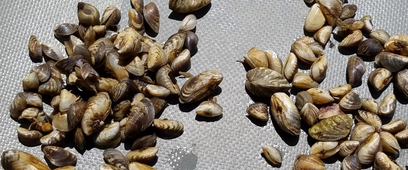
In 1989, GLERL launched a small research project on nonindigenous species. Research started with the ecosystem impacts of Bythotrephes, the “spiny water flea,” which had spread through most of the Great Lakes. However, with the discovery of Zebra mussels (Dreissena polymorpha) in Lake St. Clair, and the passage of the Nonindigenous Aquatic Nuisance Prevention and Control Act of 1990, GLERL was tasked with developing a major program on nonindigenous species, focusing on the ecosystem and environmental effects of the Zebra mussel. Through this program, GLERL scientists discovered the dramatic decline of the important, native amphipod Diporeia, first noted in Lake Michigan in the early 1990s. The ramifications of the Diporeia decline have been far reaching, affecting a series of ecologically and economically important fish.
1990s
Lake Michigan Field Station
In 1990, GLERL assumed ownership of the former Coast Guard base at Muskegon, Michigan on the south side of the channel between Muskegon Lake and Lake Michigan. The site includes three buildings and research vessel dockage next to the main building. The U.S. Coast Guard established the Muskegon Life Saving Station in 1879, and a building was constructed at the current location in 1905. With its distinctive building architecture and prime location adjacent to public parks, the field station has become an icon of the Muskegon community. In 1995, the site was officially named the Lake Michigan Field Station.
NOAA GLERL’s Lake Michigan Field Station
Great Lakes CoastWatch Node
In 1990 the Great Lakes CoastWatch node was established as part of NOAA’s nationwide CoastWatch program, which helps people access and use global and regional satellite data for ocean and coastal applications. Great Lakes CoastWatch delivers environmental data and products for near real-time observation of the Great Lakes. It supports ecological forecasting, monitoring algal blooms, tracking sediment plumes, studying temperature effects on fish populations, and more.
GLERL hydrologist Deborah Lee utilizes GLERL’s early CoastWatch website in the 1990s. Today, Ms. Lee serves as the Director of NOAA GLERL.
Invasive mussel research
GLERL’s experimental work on invasive Dreissenid mussels expanded in the 1990s, focusing on feeding, growth, nutrient excretion, and other processes to help to explain mussels’ impacts on Great Lakes’ food webs. Now, the understanding gained from these studies is used by resource managers to inform decisions that support coastal infrastructure and economically important fisheries.
Invasive mussels from the floor of Lake Michigan
Episodic Events Great Lakes Experiment
A large, interdisciplinary research program known as EEGLE (Episodic Events Great Lakes Experiment) was led by GLERL scientists from 1997 to 2002. The project sought information on the importance of resuspended materials caused by spring storm events in Lake Michigan. This project served as the foundation for GLERL’s present-day Real-time Coastal Observation Network.
Expanding GLERL’s reach
In 1994, the first GLERL website went live. In 1998, GLERL became involved in the National Ocean Sciences Bowl Midwest Regional Competition for high school students, which continues to be an important annual outreach event hosted by the University of Michigan School for Environment and Sustainability and Michigan Sea Grant.
2000s
A new era of research vessels and facilities
In 2002, GLERL acquired the research vessel Laurentian from the University of Michigan. The 80-foot vessel is part of a fleet that includes other large vessels and small boats. In 1999, staff at the Lake Michigan Field Station began retrofitting GLERL’s vessels to run on biofuels and achieved the goal of becoming a ‘petroleum-free’ fleet by 2006. Today, GLERL is helping other Federal agencies “green” their vessels through the Federal Green Fleet Working Group, formed in 2010.
R/V Laurentian docked in the Muskegon channel. March 16, 2010. Credit: NOAA.
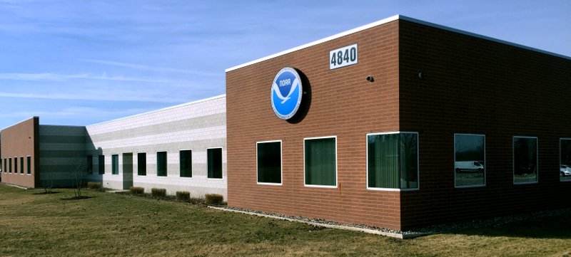
In late 2008, GLERL’s Ann Arbor facility moved across town to a new facility with much greater square footage and improved laboratory facilities, marine instrumentation storage and staging areas, and conference room space.
NOAA GLERL’s current Ann Arbor laboratory facility.
Supporting ballast water laws with invasive species research
In the early to mid-2000s, GLERL’s invasive species research played an instrumental role in providing scientific evidence to support the improvement of ballast water management legislation for commercial shipping traffic entering the Great Lakes, known as the No-Ballast-On-Board (NOBOB) project. While management of ballasted foreign ships was relatively well established, essentially nothing was known about the extent and mechanisms of aquatic invasive species (AIS) introductions related to foreign ships that entered the Great Lakes under the NOBOB designation.
GLERL scientistDavid Reid exiting a ballast water tank on a commercial ship while conducting research to better understand aquatic invasive species introductions in the Great Lakes.
The results of this project provided the core science needed to implement key ballast water management regulations in Canada and the U.S. to mitigate invasions from NOBOB vessels. Through GLERL’s scientific efforts and leadership of a world-class team of researchers, we have since seen a sharp decline in the introduction of new AIS into the Great Lakes basin – as reported in the State of the Great Lakes 2022 Report, no new species associated with ballast water have been introduced since 2006.
Leading Lake Erie research
GLERL led a large multi-agency experiment from 2005 to 2007 called the International Field Years on Lake Erie (IFYLE). The focus of this study was harmful algal blooms and hypoxia.
2010s
Great Lakes Restoration Initiative
Since 2010, nearly $5 billion has been invested in the Great Lakes region for restoration efforts through the Great Lakes Restoration Initiative (GLRI). The GLRI is a joint initiative of 16 federal agencies, led by the U.S. EPA, with the goal of restoring Great Lakes ecosystems.
To guide the work conducted under the GLRI, federal agencies created a comprehensive plan that prioritizes restoration and protection activities within five Focus Areas: Toxic Substances and Areas of Concern; Invasive Species; Nonpoint Source Pollution Impacts on Nearshore Health; Habitats and Species; and Foundations for Future Restoration Actions. NOAA has been allocated over $355 million in GLRI funds to accomplish restoration goals by generating ground-breaking science, creating and disseminating data products and services, and restoring critical habitats.
Cooperative Science and Monitoring Initiative (CSMI)
In the 2010s, GLERL became involved in the Cooperative Science and Monitoring Initiative (CSMI), a binational effort instituted under the Science Annex of the 2012 Great Lakes Water Quality Agreement to coordinate science and monitoring activities in one of the five Great Lakes each year. These efforts generate data and information for environmental management agencies. CSMI’s enhanced science and monitoring activities are conducted in response to priorities established by the Lake Partnerships of the Great Lakes Water Quality Agreement Lakewide Management Annex.
Two GLERL scientists conduct mussel research on the deck of a research vessel as part of CSMI.
Toledo water crisis and resulting HAB research
In 2014, Toledo, Ohio officials issued a two-day ban on drinking and cooking with tap water for more than 400,000 residents due to toxins concentrations that exceeded the World Health Organizations guideline level for safe drinking water. These toxins were a result of an algal bloom that was occurring in western Lake Erie. The economic impact of a severe algal bloom season on Lake Erie has been estimated at $65 million. This event served as a wake-up call that harmful algal blooms (HABs) can be incredibly costly, have serious economic impacts, and can pose serious threats to human health, drinking water safety, and water-dependent businesses and activities.
MODIS satellite image of Lake Erie showing harmful algal bloom. September 29, 2014. Credit: NOAA Great Lakes CoastWatch
As such, this event underscored the importance of HAB monitoring, forecasting, and research. GLERL’s HABs research program uses an integrated approach to understand the environmental drivers of HABs and hypoxia to predict events. Using satellite images, remote sensing, buoys, a comprehensive monitoring program in Lake Erie, Saginaw Bay, and Lake Huron, and advanced genetic techniques, GLERL researchers work to understand the long and short-term seasonal dynamics of HABs and hypoxia. The data collected is used to inform forecast models used by key Great Lakes stakeholder groups, such as drinking water managers.
GLERL’s Current and Future Directions
U.S. Coast Guard Great Lakes Center of Expertise for Oil Spill Response and Research
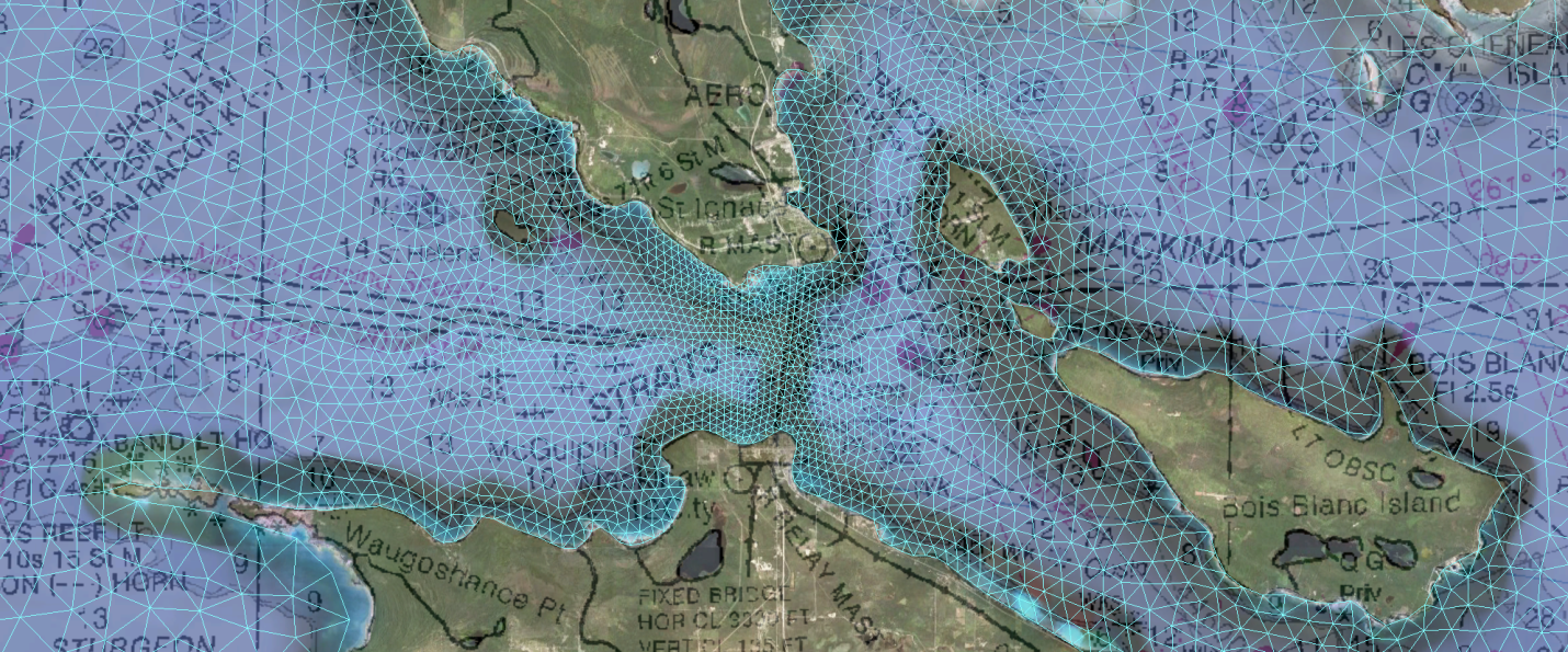
In 2021, GLERL was chosen as one of two worksites for the newly established United States Coast Guard (USCG) Great Lakes Center of Expertise (GLCOE) for Oil Spill Response and Research. GLERL experts are working to evaluate the General NOAA Operational Modeling Environment (GNOME) for the Great Lakes freshwater environment, identifying gaps for tracking oil spills such as freshwater conditions and ice effects, and developing strategies to address these gaps.
Much of GLERL’s oil spill modeling efforts focus on the Straits of Mackinac, shown here with a triangular model grid.
GLERL also incorporates its high-resolution Great Lakes Coastal Forecasting System (GLCFS) surface currents forecasts into the GNOME framework to evaluate and improve oil spill trajectories and location tracking to support potential response, rescue, and cleanup.
Our research addresses the potential impact of ice cover on oil spill trajectories including identifying efficient tracking for oil under ice, ice breaking, and wave-ice interactions.
Today’s key research areas
Today, GLERL research is carried out under three integrated science branches: Observing Systems and Advanced Technology, Ecosystem Dynamics, and Integrated Physical and Ecological Modeling and Forecasting. These three branches work together to collect the necessary information to develop and advance predictions of interconnected ecological and human systems in the Great Lakes. Current key research areas:
Food web changes since the Zebra and Quagga mussel invasion
Climate change impacts
Development of coastal forecast systems
Dissemination of satellite imagery for environmental products development
Bioavailability of toxic organic chemicals
Using eDNA and ‘omics to predict impacts of climate change and invasive species on the microbial food web and enhance our ability to predict and monitor HABs
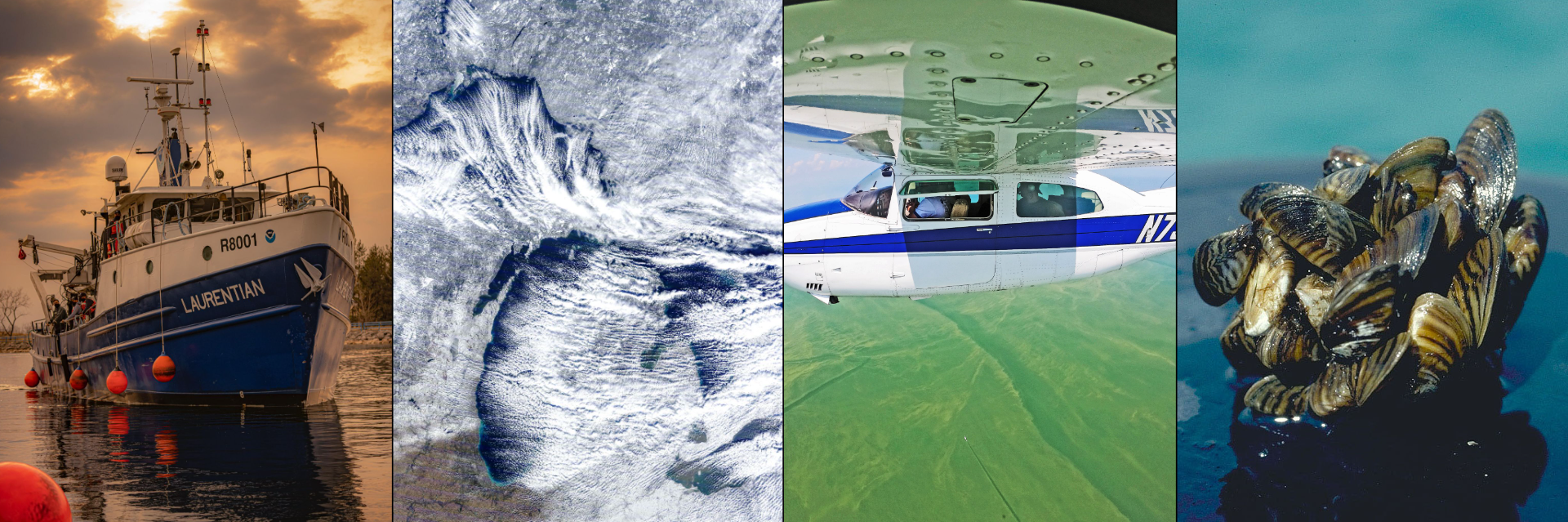
Collage of four photos showing the R/V Laurentian, a satellite photo of a lake effect snow event, a small plane conducting remote sensing research on algal blooms, and a cluster of invasive mussels.