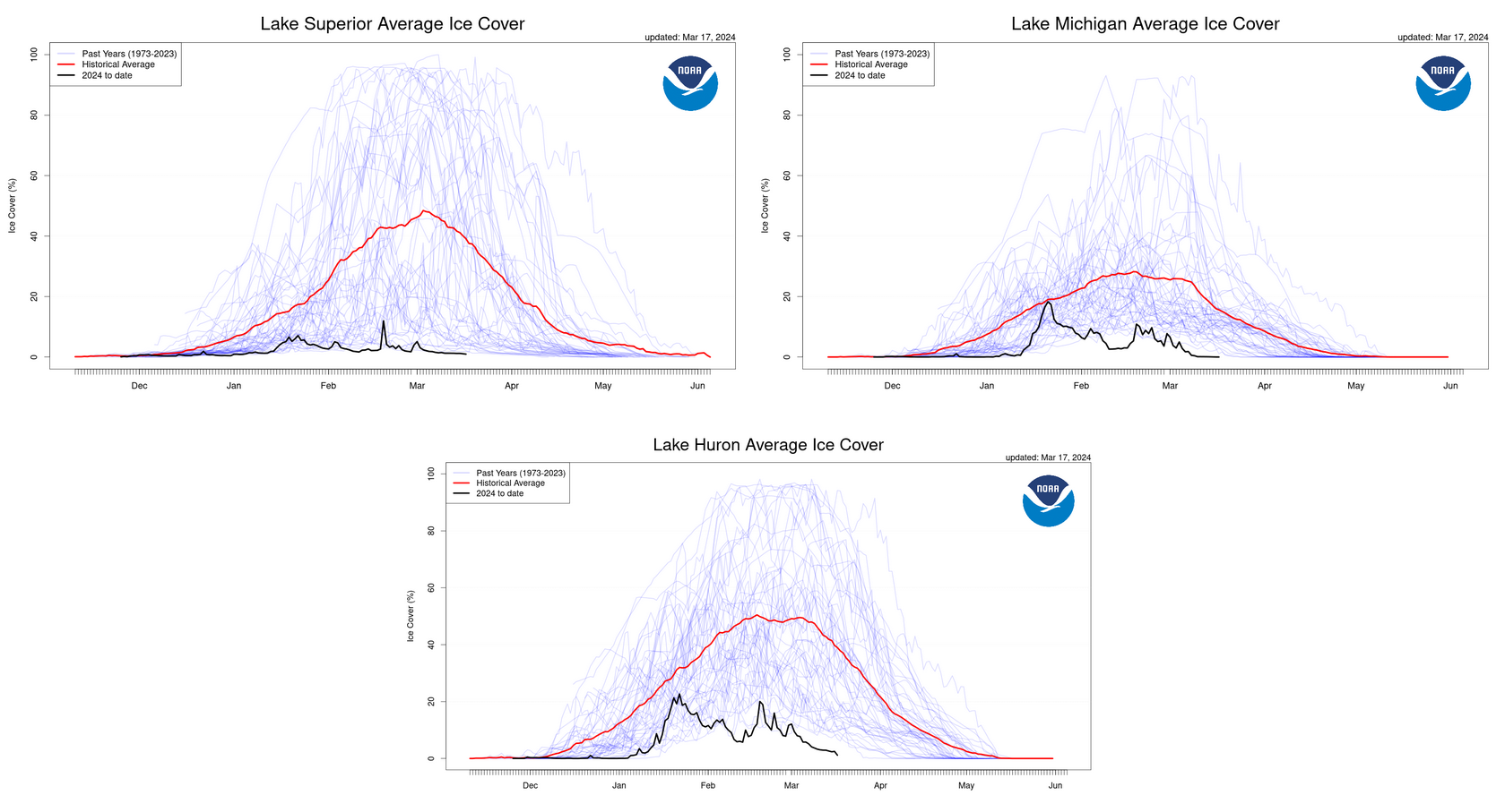
As we welcome the first day of spring, many people are curious how 2024’s Great Lakes ice cover data officially stacks up against previous years. But because ice cover typically peaks in late February or March, the Great Lakes ice season actually extends through much of the spring, into late April or early May. (In years with high ice cover, the northern areas of Lake Superior can still have ice as late as June!)
Although this year’s ice is lower than usual, NOAA GLERL will continue monitoring ice conditions through April as in past years. In the meantime, here’s a look at the numbers from this ice season so far.
Annual Maximum Ice Cover
Maximum ice cover on the Great Lakes peaked at 16% on January 22nd, which gives 2024 the fourth lowest annual maximum ice cover for the five lakes as a whole since records began in 1973. Additionally, Lake Huron set a new low record for its annual maximum ice cover, peaking at 22.6% on the same date. The previous record low for Lake Huron was 23.1% in 2012.
While Lake Superior’s ice cover was also the fourth lowest on record, this lake would have set a record low if not for a cold snap that brought its ice from 2.6% to 12% in a single day.
Average Ice Cover from January 1 to March 17
While it’s interesting to look at the numbers for maximum Great Lakes ice cover, Lake Superior’s one-day spike this year is a great example of how maximum ice values don’t tell the whole story. Looking at average ice throughout the season is more relevant for studying long term trends. In 2024, average Great Lakes ice cover from January 1st through March 17 set a record low. Average ice cover for this time period was 5.0%, breaking the previous record low of 5.5% set in 2012. It’s most likely that once the season is over, the final seasonal average will rank among the lowest recorded.
Looking at the lakes individually, Lakes Superior, Michigan and Huron all broke their low records for average ice during this time period as well.
Current Conditions and Remainder of the Ice Season
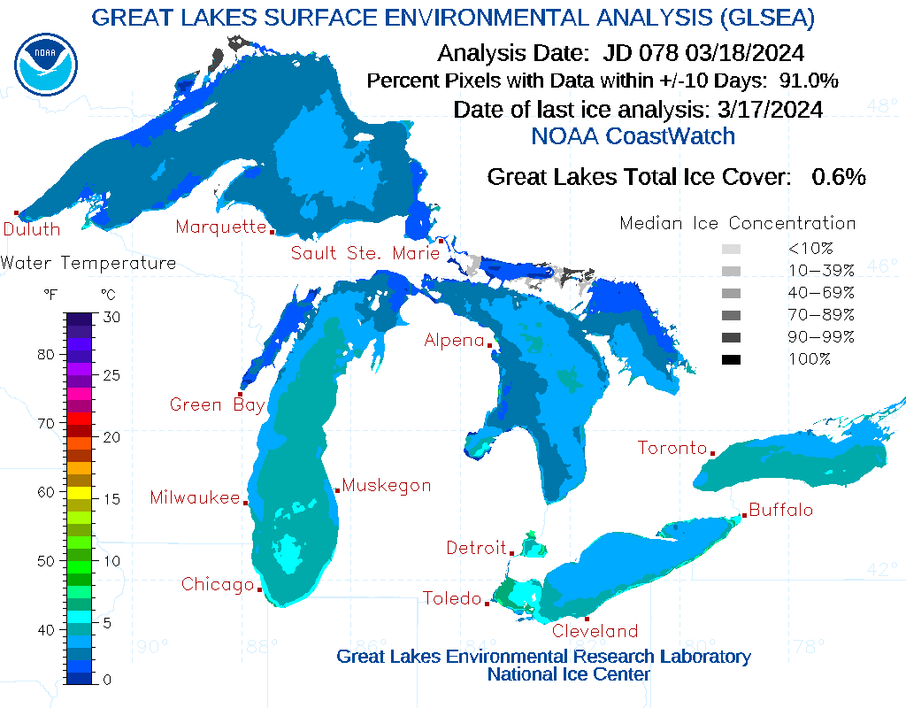
Currently, Great Lakes ice cover is less than 1%. Cold air masses may still bring cooler temperatures to the region throughout early spring; however, air temperatures are unlikely to stay below freezing long enough to cause any notable increase in lake ice. As the northernmost lake, Lake Superior could see an uptick in shoreline ice if cold temperatures persist, but in the end this would not change the record-low status of this year’s ice cover.
Check back later this spring for a final assessment of the 2024 ice season!
Additional Resources
Learn more about NOAA GLERL’s ice cover research on our ice homepage.
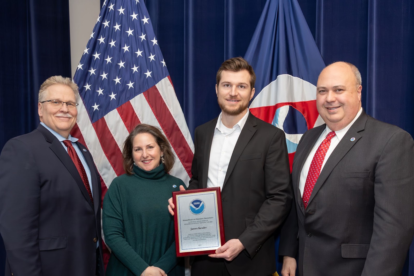
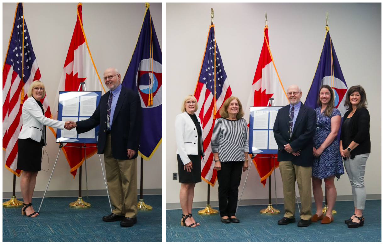
NOAA GLERL Physical Scientist James Kessler recently received a NOAA National Ocean Service (NOS) Peer Recognition Award for outstanding day-to-day collaborative efforts involving crosscutting programmatic tasks that contributed to the accomplishments of the NOS mission.
Peer Recognition “Rafting” Awards recognize coordination among NOS offices and provide NOS employees the opportunity to express their appreciation to another NOAA federal colleague that has helped them in some unique way. Congratulations, James, from all of us at NOAA GLERL!
The award nomination below describes James’ invaluable contributions to interagency collaborations between NOAA NOS, NOAA’s Office of Oceanic and Atmospheric Research (OAR), and the U.S. Coast Guard:
The Great Lakes contain 20 percent of the world’s surface freshwater supply and provide drinking water to over 40 million people. When a pollution event or natural disaster occurs, NOAA’s National Ocean Service Office of Response and Restoration (NOS/OR&R) is responsible for providing scientific analysis that supports decision makers recommendations of protecting life, property, and the environment. To accomplish this, OR&R often draws upon subject matter expertise from other parts of NOAA. This award is to recognize the outstanding professional performance of James Kessler (OAR/GLERL) when selected to participate and support two different OR&R events.
The first was an invitation for Mr. Kessler to participate in the U.S. Coast Guard (USCG) led oil spill exercise held in Roger’s City, MI on July 19, 2022. Showcasing NOAA’s role and ability to provide unified scientific support to the USCG during a spill emergency is imperative. The success of this public event with an audience of federal, state, and local emergency responders was a testament to the positive collaboration between NOS/OR&R and OAR. This particular exercise was significant as the USCG obtained approval to use a highly visible green dye in the water to mimic spilled oil in order to highlight environmental transport in the exercise area. Without previous emergency response experience, James Kessler provided detailed information on the hydrodynamic properties of Lake Huron with uncommon zeal and vitality. He developed an oil dispersion animation for the exercise scenario using the Great Lakes Operational Forecast System (GLOFS), ran the model during the event, and presented to over 100 attendees the GLOFS, High-Resolution Rapid Refresh (HRRR), and Global Forecast System (GFS) systems. Mr. Kessler displayed expert knowledge of NOAA Great Lakes capabilities including the Great Lakes Observing System (GLOS) and often brought in a representative to discuss observation systems and gaps in coverage with interested stakeholders.
The collaboration between OR&R and GLERL directly reflected NOS priorities of preparedness and risk reduction; as well as NOAA’s strategic priorities of communicating NOAA’s comprehensive observing systems and partnerships in the Great Lakes that improve data delivery and services to government and state agencies, as well as private industry stakeholders. In another example representing Mr. Kessler’s support, the newly established USCG Center of Expertise (COE) in partnership with the OR&R, funded a research project to test uncrewed aircraft systems’ (UAS) ability to collect and share data from a USCG vessel in an ice environment. James Kessler joined the project planning team in January and delivered time critical analysis of current and historical ice data for the Great Lakes.
Mr. Kessler’s astute analysis of ice data archives between 1973-present and initiative to generate time series plots provided concrete information for project managers to shift the dates and location of the project to ensure proper ice conditions. As a result, the field deployment component of the project was moved from January 22 in Port Huron, to March 6 in Duluth, MN and directly led to the successful capture of a USCG vessel breaking fresh ice and completion of the first field experiment funded by the COE. The successful outcome of this project also led to defining protocols for data sharing between USCG and NOAA that will vastly improve product support for pollution spills and disaster responses nationwide. While in the field, Mr. Kessler’s charisma was noted on a daily basis by USCG SES and earned him a deep sense of respect by all within the project team. His exceptional professional knowledge, enthusiasm, and dedication to mission contributed significantly and was the motivating force to keep collaborative efforts between NOS/OR&R, GLERL, and USCG moving forward.
February 22, 2024
by Gabrielle Farina Comments Off on Q&A with NOAA scientists: Causes and impacts of 2024’s historically low Great Lakes ice cover
Many people have questions about the historically low Great Lakes ice cover this winter, and we’ve got answers! NOAA GLERL’s Bryan Mroczka (Physical Scientist) and Andrea Vander Woude (Integrated Physical and Ecological Modeling and Forecasting Branch Chief) answer the following frequently asked questions regarding the causes and impacts of this year’s low ice cover.
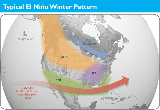
What’s driving the lack of ice? Is El Niño involved somehow?
The long-term trend shows a decline in ice cover in the Great Lakes region over the past several decades. Ice cover has been decreasing by approximately 5 percent per decade, for a 25 percent total decrease between 1973 and 2023. In addition, the length of the Great Lakes ice season has decreased by approximately 27 days on average over the same period.
Annual maximum ice cover on the Great Lakes, 1973-2023.
Factors that drive the lack of ice are climatic variables such as the El Niño-Southern Oscillation (ENSO) along the Equatorial Pacific in addition to other global oceanic oscillations. These atmospheric patterns in the ocean influence weather patterns in the Great Lakes, driving the climatic response of the lakes. Increases in air temperatures are responsible for the lack of ice in addition to the “heat memory” of the lakes as they retain heat from the summer season temperatures.
While El Niño may have exacerbated the extreme low ice seen this year, the increased frequency of low ice years across the lakes is tied to generally warmer winter conditions, defined by fewer and generally shorter intrusion of arctic air into the region. While much of the Continental U.S. has seen a warming trend during the winter months, the upper Midwest/Great Lakes have seen some of the most dramatic warming.
This graph shows maximum ice concentration every year from 1973-2024, with color-coding to show El Niño strength each year. Note that 2024’s maximum ice cover of 16% is as of mid-February, and is subject to change if ice cover increases later in the season.
An important factor in a season’s ice potential across the Great Lakes is the weather patterns influencing the region during December. December is what we would consider a “priming” month, in which the first arctic air masses cool the lakes and begin the ice generation process within enclosed bays and along the shoreline. Recently, we have seen a multitude of Decembers exhibit above-average temperatures, including significantly above-average temperatures this winter in particular. The lack of early season cold air, and resulting late start to the ice generation season makes later significant gains in ice concentration harder to achieve.
How does the lack of ice impact the Great Lakes ecosystem, as well as towns and cities on the lakes?
Ice is an important element for the ecosystems, economy, and coastal resilience across the Great Lakes. Ice is a natural part of the Great Lakes yearly cycle and many animal species, from microbial to larger fauna, rely on the ice for protecting young and harboring eggs. The Great Lakes also see most of their significant storms and large wave events during the colder months of late fall through winter. The shorebound ice sheets act as an important buffer against these waves, protecting the coast from erosion and damage to shoreline infrastructure. In years with very low ice, such as this one, the coast becomes more susceptible to the full onslaught of wave energy.
Ice on the Lake Huron shoreline near Oscoda, MI on January 27, 2024. Credit: Clarice Farina
The economy of the Great Lakes can see negative and positive outcomes from a very low ice year. Two of the more important wintertime recreational sports in the Great Lakes include ice-fishing and snowmobiling. When the ice is scarce and thin, the ability to partake in ice-fishing is significantly reduced both spatially and temporally. When it comes to snowmobiling, warmer winters will generally result in more rain events compared to normal, as well as reduced snow cover and lower quality snow.
One “silver lining” for the Great Lakes economy that may result from a low ice year, is a boost to the shipping industry. Low ice years are likely to extend the shipping season across the lakes, and may extend the season significantly if the locks are not hampered by significant ice.
Is there still time for the ice to return before spring?
The ice season in the Great Lakes typically extends until the end of March, and the maximum ice cover for the year comes near the end of February to early March. The clear trend is one of decreasing ice, but it is still too early to determine how this year will ultimately compare to past years and the long term average.
Winter is not close to being over, and periods of new ice generation are almost certain as we head through the next month. The longer term pattern into early March does suggest that a few bouts of arctic air will reach the Great Lakes, but similar to earlier portions of this winter, there does not appear to be a signal for any long term below average temperature events. The colder air events ahead are more likely to be short-lived (several days), and not long enough for significant gains in ice concentration. It is certainly possible that we’ll see the ice concentrations climb out of the current historic lows before the end of the month, but a major pattern shift (currently not in the forecast) would be required to drive ice concentrations out of below-normal realms for any of the lakes before the spring.
How do low ice levels impact evaporation, water levels, and lake effect snow?
While Great Lakes water levels are generally lowest in the winter, most of the evaporation from the lakes actually happens in the fall. This is because evaporation is driven by a large difference between the air temperature and the water temperature, which happens in the fall when the air cools down but the water is still holding onto its summer heat. The graphic below illustrates the seasonal cycles that Great Lakes water levels undergo every year.
As of right now, we are not seeing any significant impacts to water levels due to the lower ice. Water levels are essentially the same (within one inch) as the values we were seeing at this time last year, and running just a touch above the long term average. The U.S. Army Corps of Engineers is forecasting very little change in water levels for the next 6 months. The lakes are almost ice-free, but we are also not seeing any significant degree or duration of arctic air. Despite the lack of ice, the water temperatures are still cold – just a few degrees above freezing – so the generally small difference in water temperature and air temperature means that evaporation levels are kept in check.
One might assume that the lakes remaining ice-free might increase the amounts of lake effect snow, and this is possible given there is still a steady supply of colder air supportive of driving the lake effect. However, this winter, the lack of cold air arriving over the region has reduced the lake effect snow events, and promoted significant melting between events.
Why do NOAA GLERL’s ice records only go back to 1973?
The early 1970s is when we first had reliable satellite data with which to construct more accurate and complete datasets. Before the satellite era, information during the winter about ice concentration away from the shoreline was very limited. This is why we only use the 51-year dataset for our calculations, as this represents the highest quality data.
From flood forecasting to winter buoys, 2023 has been a year full of innovative Great Lakes research at NOAA’s Great Lakes Environmental Research Laboratory (GLERL). As we get ready to ring in 2024, here’s a roundup of our top research stories throughout the year!
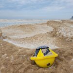
For a long time now, scientists have wanted to know more about what happens under the ice of the Great Lakes each winter, but getting the data has always been extremely challenging or almost impossible in this region. Over the last few years, NOAA GLERL has been working to develop new tools that may provide a fresh glimpse into the season. Read more
A small yellow Spotter buoy rests on the sand-covered ice after being washed ashore by winter waves.Credit: Russ Miller, CIGLR
For engineers and scientists, sometimes failure means progress. On August 5, 2023, scientists from NOAA GLERL, NOAA’s Atlantic Oceanographic and Meteorological Laboratory (AOML), and the Monterey Bay Aquarium Research Institute (MBARI) watched as a new solar powered surface vehicle, the SeaTrac, sailed off across the Great Lakes. Read more
NOAA GLERL engineer Kyle Beadle (left) and scientist Reagan Errera load a Third Generation Environmental Sample Processor into a SeaTrac autonomous surface vehicle in order to study the Lake Erie harmful algal bloom using ‘omics technology.
In the world of NOAA, some of the most significant scientific advancements come as a response to natural disasters. Over the past decade, NOAA GLERL has been working with international partners to develop new tools to mitigate flooding on the Lake Champlain-Richelieu River basin. Read more
Satellite photo of Lake Champlain by the European Space Agency’s Sentinel 2.
Personnel Highlights of 2023
2023 was also a year full of accomplishments and recognition for GLERL’s leadership, scientists, and alumni. Congratulations to these members of the NOAA GLERL family!
This year, NOAA GLERL Director Deborah Lee was credentialed as an Envision Sustainability Professional by the Institute for Sustainable Infrastructure. She is the first NOAA employee to do so, and joins a group of more than 3400 engineering professionals nationwide with this credential. Read more
GLERL Scientist Ed Rutherford, former CIGLR technician David Wells, GLERL Director Deborah Lee, and GLERL technician Paul Glyshaw on the RV Laurentian while performing a spatial cruise sampling at Thunder Bay Marine Sanctuary in Lake Huron.
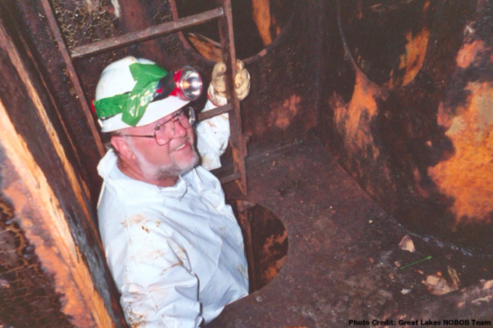
During his career at NOAA GLERL, Dr. David Reid’s work played an instrumental role in providing scientific evidence to support the improvement of ballast water management legislation for commercial shipping traffic entering the Great Lakes. Through this work, we have seen a sharp decline in the introduction of new AIS into the Great Lakes basin and a heightened awareness of the impacts that invasive species can have on our ecological, economic, and cultural resources. Read more
Former NOAA GLERL scientist Dave Reid shakes hands with NOAA GLERL Director Deborah Lee during a ceremony recognizing his contributions to invasive species research in the Great Lakes.
Several of our scientists were recognized on Research.com’s list of “World’s Best Scientists” for 2023! This ranking identifies and celebrates exceptional individual researchers who are having a significant impact on the research community. NOAA GLERL and Cooperative Institute for Great Lakes Research (CIGLR) scientists are listed in the categories of Ecology and Evolution and Environmental Sciences. Read more
Want to keep up with NOAA GLERL’s latest research and accomplishments in 2024? Follow us on Twitter, Instagram and Facebook to stay updated!
November 29, 2023
by Gabrielle Farina Comments Off on Lake effect snow: What, why and how?
As fall comes to a close, those who live and work in the Great Lakes region are wondering what weather this winter has in store. An El Niño Advisory is currently in effect, which means El Niño conditions have developed and are expected to continue. So, what does that mean for the Great Lakes? Will we still see lake effect snow?
An El Niño shifts the odds towards warmer, drier weather across the region – but that certainly doesn’t mean no snow! Whether or not there’s an El Niño, lake effect snow events can and do occur in the Great Lakes every year. In fact, we’re already experiencing them this year in places like Buffalo, NY and western Michigan.
During El Niño winters, the polar jet stream tends to stay to the north of the Great Lakes region, while the Pacific jet stream remains across the southern U.S. With the Great Lakes positioned between the storm tracks, warmer and possibly drier conditions can develop during El Niño events.
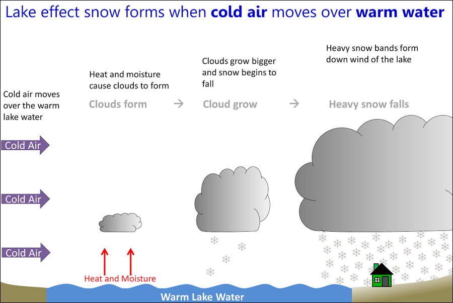
What is lake effect snow?
In the Great Lakes region, hazardous winter weather often happens when cold air descends from the Arctic region. Lake effect snow is different from a low pressure snow storm in that it is a much more localized and sometimes very rapid and intense snow event. As a cold, dry air mass moves over the unfrozen and relatively warm waters of the Great Lakes, warmth and moisture from the lakes are transferred into the atmosphere. This moisture then gets dumped downwind as snow.
Lake effect snow storms can be very dangerous. For example, 13 people were killed by a storm that took place November 17-19, 2014 in Buffalo, New York. During the storm, more than five feet of snow fell over areas just east of Buffalo, with mere inches falling just a few miles away to the north. Not only were lives lost, but the storm disrupted travel and transportation, downed trees and damaged roofs, and caused widespread power outages. Improving lake effect snow forecasts is critical because of the many ways lake effect snow conditions affect commerce, recreation, and community safety.
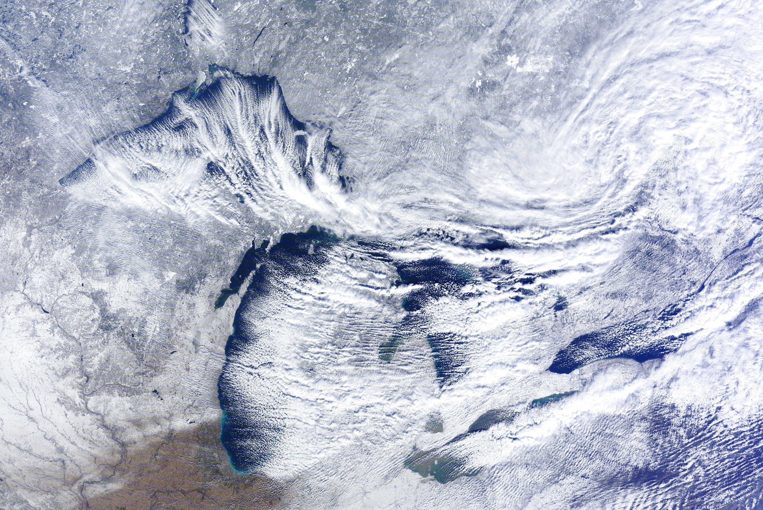
MODIS satellite image of a lake effect snow event in the Great Lakes, caused by extensive evaporation as cold air moves over the relatively warm lakes. November 20, 2014. Credit: NOAA Great Lakes CoastWatch.
Why is lake effect snow so hard to forecast?
There are a number of factors that make lake effect snow forecasting difficult. The widths of lake-effect snowfall bands are usually less than 3 miles — a very small width that makes them difficult to pinpoint in models. The types of field measurements scientists need to make forecasts better are also hard to come by, especially in the winter! We would like to take frequent lake temperature and lake ice measurements, but that is difficult to do during the winter, as conditions are too rough and dangerous for most research vessels and buoys. (However, NOAA is making progress towards expanding our Great Lakes winter observation capabilities!)
Satellite measurements can also be hard to come by, as the Great Lakes region is notoriously cloudy in the winter. It’s not uncommon to go for over a week without usable imagery.
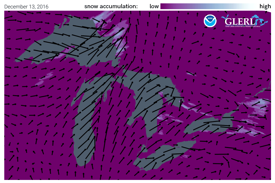
Lake Effect Snow animation: This mid-December 2016 lake effect snow event resulted in extremely heavy snow across Michigan, Ohio, upstate New York as well as the province of Ontario east of Lake Superior and Huron.
NOAA GLERL and CIGLR work to improve lake effect snow forecasting
Currently, NOAA Great Lakes operational models provide guidance for lake effect snow forecasts and scientists at NOAA GLERL and the Cooperative Institute for Great Lakes Research (CIGLR) are conducting studies to improve them.
They use data from lake effect snow events in the past and compare how a new model performs relative to an existing model. One way to improve forecast model predictions is through a model coupling approach, or linking two models so that they can communicate with each other. When they are linked, the models can share their outputs with each other and produce a better prediction in the end.
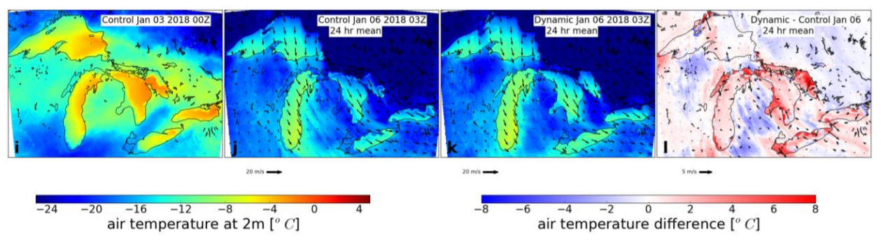
Research published by CIGLR, GLERL and other research partners, “Improvements to lake-effect snow forecasts using a one-way air-lake model coupling approach,” is part of a series of studies (see list below) that help to make lake effect snow forecasts better. This study takes a closer look at how rapid changes in Great Lakes temperatures and ice impact regional atmospheric conditions and lake-effect snow. Rapidly changing Great Lake surface conditions during lake effect snow events are not accounted for in existing operational weather forecast models. The scientists identified a new practical approach for how models communicate that does a better job of capturing rapidly cooling lake temperatures and ice formation. This research can result in improved forecasts of weather and lake conditions. The models connect and work together effectively and yet add very little computational cost. The advantage to this approach in an operational setting is that computational resources can be distributed across multiple systems.
Study model run: This panel of images shows model runs that looks at data from a lake effect snow event from January 2018 with and without the new type of model coupling. The image on the far right labeled Dynamic – Control Jan 06 shows the differences in air temperature (red = warmer, blue = colder) and wind (black arrows) when the models are coupled. The areas in color show how the new model coupling changed the model output considerably and improved the forecast.
Our lake effect snow research continues
Our lake effect modeling research is ongoing, and NOAA GLERL, CIGLR, NOAA NWS Detroit, the NOAA Global Systems Laboratory continue to address the complex challenges and our studies build upon each other to improve modeling of lake-effect snow events. A future focus will be on running the models on a smaller grid scale and continuing to work to improve temperature estimates as both are key to forecasting accuracy.
NOAA’s Great Lakes Environmental Research Laboratory (GLERL) is pleased to recognize that several of our scientists have recently been recognized on Research.com’s list of “World’s Best Scientists” for 2023. This ranking identifies and celebrates exceptional individual researchers who are having a significant impact on the research community. NOAA GLERL and Cooperative Institute for Great Lakes Research (CIGLR) scientists are listed in the categories of Ecology and Evolution and Environmental Sciences.
Gregory Dick (Director, Cooperative Institute for Great Lakes Research)
Congratulations to these scientists for this well-deserved recognition!
September 7, 2023
by Gabrielle Farina Comments Off on Former NOAA GLERL scientist recognized for career achievements in reducing Great Lakes aquatic invasive species introductions
This week, NOAA GLERL and partners had the pleasure of formally recognizing Dr. David Reid, whose research on aquatic invasive species (AIS) has had significant positive impacts on the health of the Great Lakes. Recognizing this renowned former GLERL scientist and his important research serves as an exciting kickoff to the celebration of our laboratory’s 50th anniversary in 2024!
Dr. Reid’s work played an instrumental role in providing scientific evidence to support the improvement of ballast water management legislation for commercial shipping traffic entering the Great Lakes. Through Dr. Reid’s scientific efforts and leadership of a world-class team of researchers, we have seen a sharp decline in the introduction of new AIS into the Great Lakes basin and a heightened awareness of the impacts that invasive species can have on our ecological, economic, and cultural resources.
Left: NOAA GLERL Director Deborah Lee presents David Reid with a letter recognizing his significant career accomplishments in reducing aquatic invasive species in the Great Lakes. Right: David and Helaine Reid stand with Deborah Lee (NOAA GLERL) Ceci Weibert (Great Lakes Commission), and Heather Stirratt (International Joint Commission)
Beginning his tenure with NOAA GLERL in 1985 as a physical scientist, Dr. Reid has worked on a wide variety of projects that have provided substantial benefits to the greater Great Lakes research and management community. By combing through hundreds of historic reports from a diversity of sources throughout his career, in the early 2000s he helped to create the first comprehensive database of bulk ship traffic cargo patterns (as a surrogate for ballast data) for the Great Lakes. This database served as a predecessor of National Ballast Information Clearinghouse as well as revealing links between ship cargo movement and AIS introductions.
With almost no prior experience within the field, Dr. Reid helped to build a world-class research team to tackle one of the most significant challenges in invasion management in the Great Lakes, the NOBOB (No-Ballast-On-Board) challenge. While management of ballasted foreign ships was relatively well established, essentially nothing was known about the extent and mechanisms of AIS introductions related to foreign ships that entered the Great Lakes under the NOBOB designation. Under Dr. Reid’s leadership, a binational scientific research project was convened, engaging a diverse group of experts from NOAA’s government, university, and industry partners.
David Reid exiting a ballast water tank on a commercial ship while conducting research to better understand aquatic invasive species introductions in the Great Lakes.
Helping to lead this team and secure funding support for over 6 years of study provided the core science needed to implement key ballast water management regulations in Canada (2006) and the U.S. to mitigate invasions from NOBOB vessels. Through his unwavering commitment to building consensus among U.S. and Canadian governments and stakeholders, Dr. Reid has made significant contributions to the development of ballast water management requirements in the Great Lakes St. Lawrence Seaway System – the most stringent in the world – to prevent aquatic invasions through marine and Great Lakes shipping.
Dr. Reid also envisioned a ‘one stop shop’ website where Great Lakes researchers could share verified information on current and predicted AIS, which would allow researchers to avoid duplication of basic efforts and ‘get ahead of the curve’ in addressing new invasions. He envisioned this new database as a regional node in a distributed network of databases operating at local to international levels, playing a key role in both verifying and aggregating information at the regional scale. The Great Lakes Aquatic Nonindigenous Species Information System (GLANSIS – launched in 2003) has grown from that vision to now serve the AIS-related information needs of researchers, managers, educators and stakeholders throughout the region.
David Reid stands with GLANSIS Manager Rochelle Sturtevant in front of a GLANSIS poster.
Dr. Reid’s tireless efforts to address the ballast water vector for the introduction of invasive species to the Great Lakes and his efforts to promote regional information sharing have borne fruit. As reported in the State of the Great Lakes 2022 Report (based on data synthesized by GLANSIS) no new species associated with ballast have been introduced since 2006. As concluded in the recent invasion analysis of Ricciardi and MacIsaac (2022): “To our knowledge, the 2006/2008 regulation is the only case of a policy intervention that is linked to a massive reduction of the invasion rate of a large aquatic ecosystem. Since the current regulations were implemented, the overall rate of discovery of new non-native species declined by 84.6% compared to the partial regulation period. No other equivalent period of time in the documented history of the Great Lakes basin since 1835 has had fewer invaders discovered than the period of 2007−2019…”
Dr. Reid’s own words on the impacts of his work.
Even in retirement, Dr. Reid has continued to work with the shipping management agencies to ensure the new regulations are working effectively. Now, he is being formally recognized by the Aquatic Nuisance Species Task Force, the Great Lakes St. Lawrence Seaway Development Corporation, the International Joint Commission, the Great Lakes Commission and the Great Lakes Fishery Commission for his tremendous accomplishments and many years of service towards protecting our Great Lakes.
The Great Lakes community sincerely thanks and congratulates you, Dr. Reid!
August 16, 2023
by Gabrielle Farina Comments Off on From interesting pet to invasive species: The dangers of releasing exotic plants and animals into the wild
In the Great Lakes and beyond, invasive species can wreak havoc on aquatic and terrestrial ecosystems. Even the most widespread biological invasions once began from a single moment of introduction into a new region. In several cases, the origin of an invasive species has been the release of exotic house pets into the wild.
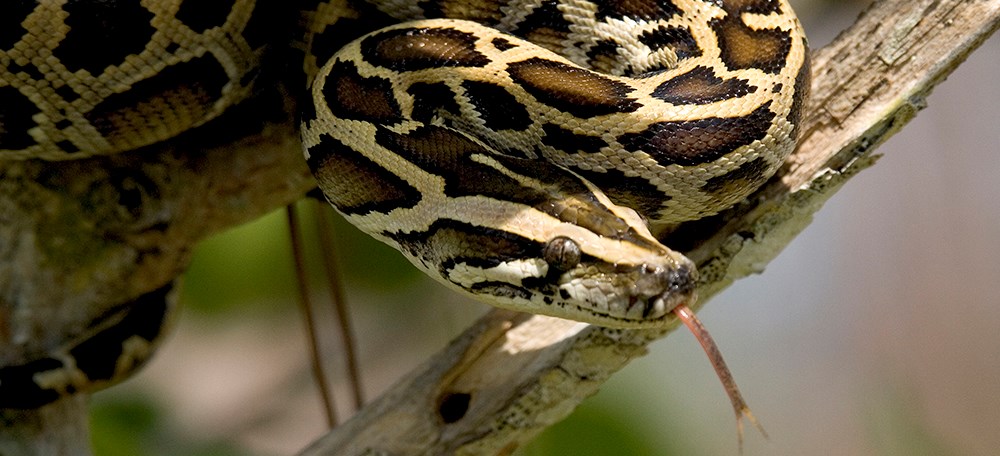
A 10-foot long reticulated python was recently found in Metro Detroit after escaping its enclosure, and in this case the animal was luckily returned safely to its owner. While the incident was regarded as a lighthearted news story, it’s important to recognize that the release or escape of non-native pets such as this python can potentially lead to serious ecological impacts.
Pythons’ major ecological toll on the Everglades
The presence of the nonindigenous Burmese python in Florida’s Everglades National Park is one example of the devastating effects that an invasive species can have on an ecosystem. Originally from Asia, this species first came to Florida as pets at least as early as 2000. As a result of their release into the wild, Burmese pythons have now established a breeding population in South Florida and are one of the most concerning invasive species in Everglades National Park, according to the U.S. Geological Survey (USGS). Pythons compete with native wildlife for food and resources and are known to prey on many local species including a variety of mammals, birds, and other reptiles. Severe mammal declines in Everglades National Park have been linked to Burmese python predation. In a 2012 study, populations of raccoons had dropped 99.3 percent, opossums 98.9 percent, and bobcats 87.5 percent since 1997, while marsh rabbits, cottontail rabbits, and foxes effectively disappeared.
Learn more about the Burmese python in the Everglades from the Florida Museum.
Non-native Burmese pythons have established a breeding population in South Florida and are one of the most concerning invasive species in Everglades National Park. Photo: National Park Service.
Similar issues in the Great Lakes
Unfortunately, the Great Lakes region has also experienced invasive species issues as a result of pets being released into the ecosystem. One example is thecommon goldfish, a freshwater fish native to Asia that is commonly kept as a pet, but which has become invasive in many areas of the United States, including in the Great Lakes region. Once goldfish are established in areas outside of their native range, they can have severe adverse impacts on the ecosystem. When goldfish forage for food, they can uproot aquatic vegetation which reduces water clarity and releases nutrients that can promote the growth of algae. Removing an established goldfish population is nearly impossible, and the economic costs are significant due to their abundance. As an example, a series of 10 goldfish management events in Minnesota removed over 1.5 million goldfish from a chain of lakes. The best way to protect against the harmful impacts of invasive goldfish is to prevent their introduction in the first place.
This 14-inch goldfish was removed from the Niagara River by the U.S. Fish and Wildlife Service. Once goldfish are established in areas outside of their native range, they can significantly impact the ecosystem. Photo: USFWS.
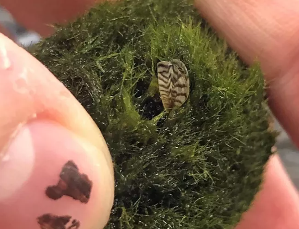
One of the most well-known invasive species in the Great Lakes is the zebra mussel, which has severely impacted the lakes’ ecosystems since their introduction in the 1980s. Unfortunately, aquarium moss balls commonly sold in pet stores are contributing to the further spread of zebra mussels across the United States. On March 1st, 2021, staff from the USGS were alerted to the presence of zebra mussels attached to or inside of moss balls sold at pet stores as aquarium plants. So far, zebra mussels found on moss balls have been reported in more than 30 states across the U.S. Zebra mussels damage freshwater ecosystems by filtering nutrients and plankton out of the water and growing or encrusting over native bottom dwelling species and submerged hard surfaces (including out-flow pipes from nearshore cities and industrial buildings, as well as boat hulls and propellers), leading to millions of dollars in damages every year to nearshore infrastructure. Aquarium owners should carefully inspect moss balls prior to placing them in their tanks and should thoroughly decontaminate their tanks if they suspect that they introduced a moss ball containing any accompanying mussel, as a precaution to ensure that zebra mussels are not spread. Doing so will minimize the potential of zebra mussels spreading to the environment where they could contaminate nearby water bodies.
Moss balls, also called marimo, are sold in the aquarium trade and have recently been found to contain zebra mussels, highly invasive species. Photo courtesy of Oregon Department of Fish and Wildlife.
From Burmese pythons in Florida to goldfish and zebra mussel-infested moss balls in the Great Lakes, these stories are examples of how releasing non-native pets can accidentally lead to the spread of invasive species with serious impacts on local ecosystems. To avoid more invasive species introductions like these, pet owners must be careful not to release non-native pets into the environment. This can be done through responsible pet ownership and research before purchase. Potential pet owners must understand that adopting a new pet requires a lot of attention and is a significant commitment.
For more information on responsible pet ownership and reducing invasive species risks, check out these resources:
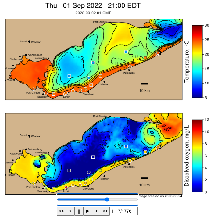
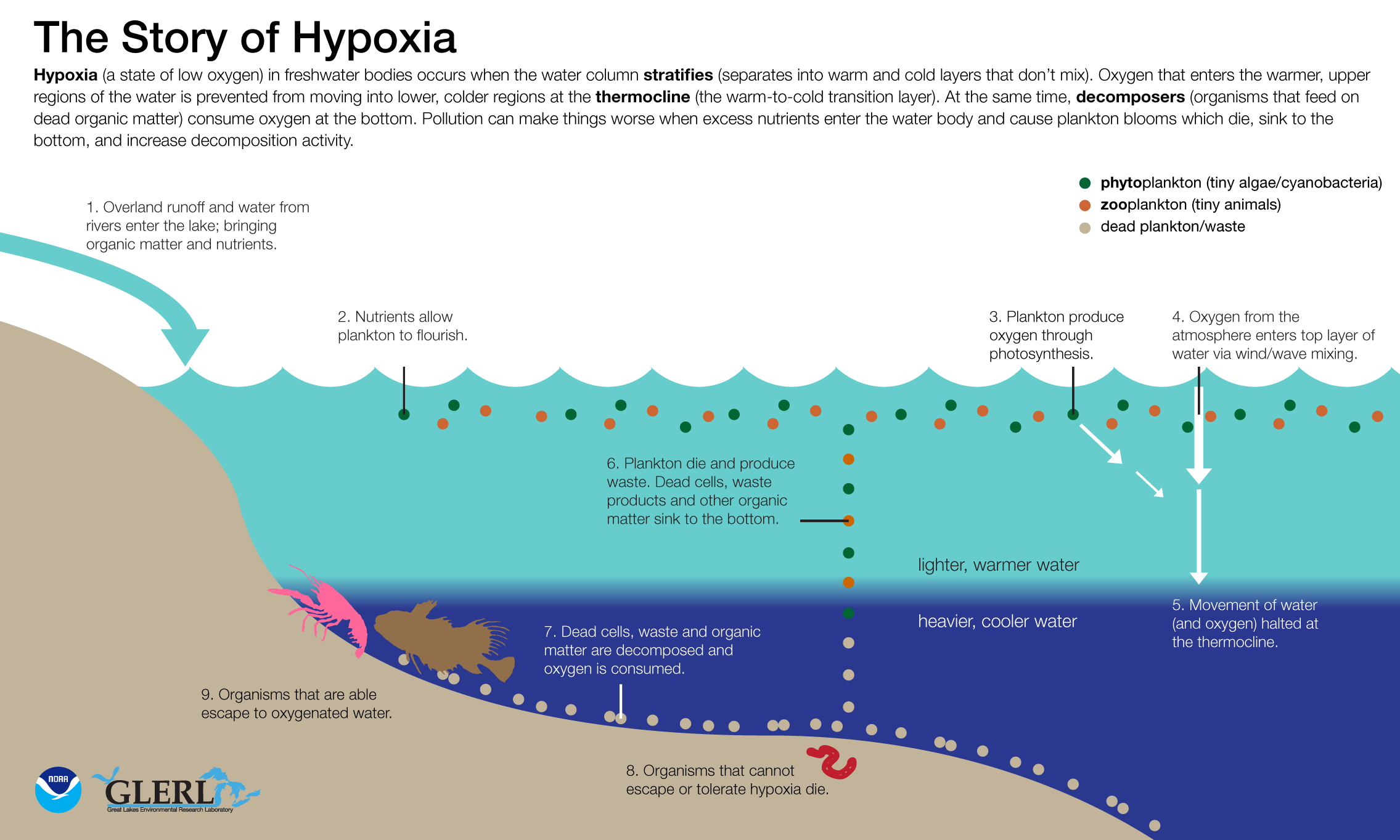
As the 2023 hypoxia season in Lake Erie is beginning, it’s interesting to look back at the 2022 hypoxia season as depicted in this retrospective animation. The animation shows model-predicted bottom temperature and dissolved oxygen from the Experimental Lake Erie Hypoxia Forecast(background color scale) with observations plotted over top (symbols) using the same color scale. When the symbol colors match the background color, the model agrees with the observations.
Hypoxia (a state of low oxygen, < 2 mg/L) can occur in lakes when the water column separates into warm and cool layers that don’t mix, as oxygen is prevented from reaching the bottom water. As in past years, hypoxia began to appear in nearshore areas in early July 2022, and filled in offshore areas of the central basin in August. The maximum extent occurred in early September, then the hypoxic zone retreated offshore as cooler temperatures and stronger winds gradually deepened the surface mixed layer. Finally, the deepest parts of the central basin became vertically well-mixed in early October, bringing an end to the hypoxia season. Sustained easterly winds at > 15 kt can cause upwelling events along the Ohio shoreline, bringing hypoxic bottom water into nearshore drinking water intakes, and potentially causing fish kills. We heard of relatively few impactful events in 2022, although widespread hypoxia did occur, which may have been a fortunate coincidence of upwelling events not occurring during peak hypoxic conditions.
Realtime observations were obtained from Cleveland Water Alliance, LimnoTech, Freeboard Technology, the Great Lakes Observing System, and Ontario Ministry of the Environment, Conservation and Parks, in collaboration with regional operators of water treatment plants including the Cleveland Water Department, and Lake County Department of Utilities. In addition, NOAA GLERL deployed a network of sensor moorings (square symbols).
This example still frame from the animation shows conditions near the maximum extent of hypoxia in 2022:
About the Project
Researchers at NOAA GLERL and CIGLR developed anExperimental Lake Erie Hypoxia Forecast model, in a five-year project (2017-2021) funded by the NOAA NCCOS Coastal Hypoxia Research Program. The model has been producing 5 day dissolved oxygen and temperature forecasts each summer since the 2017 season. A plan is in place to transition the Lake Erie Hypoxia Forecast to operations at NOAA NCCOS in 2024.
April 18, 2023
by Gabrielle Farina Comments Off on Close to HOMES – How GLERL’s Great Lakes expertise helps combat flooding in the Lake Champlain-Richelieu River Basin
Lake Champlain on September 13, 2017. Credit: European Space Agency, Sentinel-2 satellite
In the world of NOAA, some of the most significant scientific advancements come as a response to natural disasters. Events like hurricanes, wildfires, and floods influence the creation of new solutions to the problems these disasters cause. Over the past decade, NOAA’s Great Lakes Environmental Research Laboratory (GLERL) has been working with international partners to develop new tools to mitigate flooding on the Lake Champlain-Richelieu River basin.
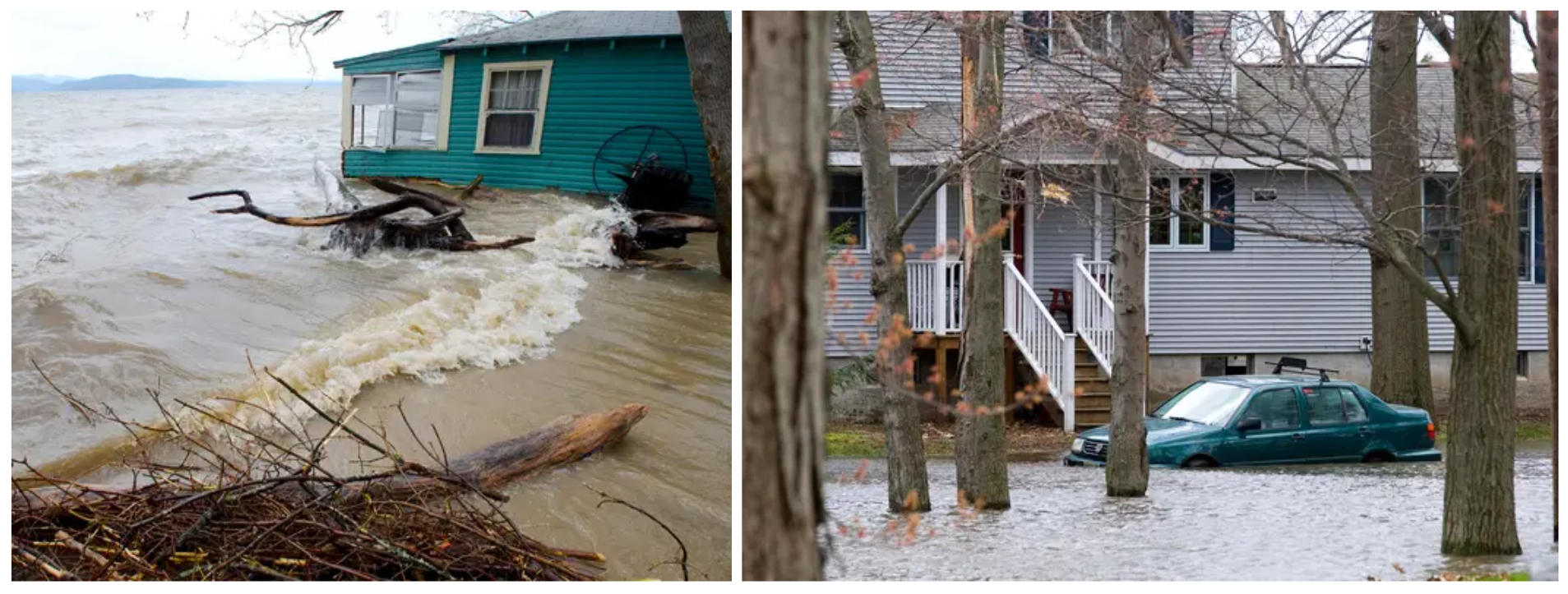
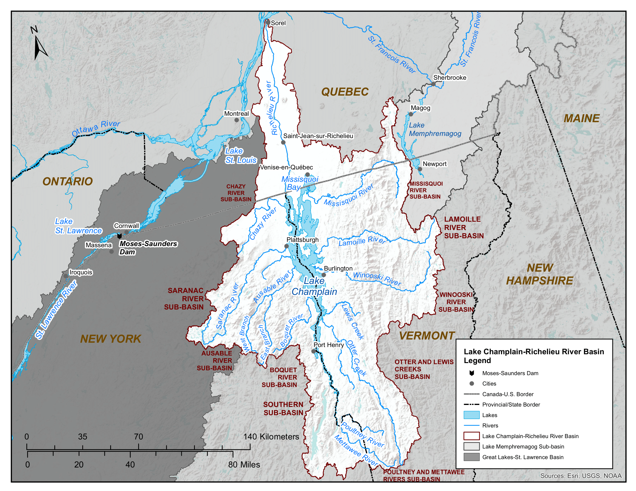
Lake Champlain is similar to the five Great Lakes as a large lake system that is shared between the United States and Canada. The lake lies along the New York/Vermont border and flows north into Quebec via the Richelieu River. In 2011, this lake-river system experienced significant precipitation and wind events that raised the levels of Lake Champlain to record levels, causing extensive flooding and damage around the lake and along the Richelieu River.
The International Joint Commission (IJC) is a bi-national organization established by the governments of the United States and Canada under the Boundary Waters Treaty of 1909. It oversees activities affecting the shared waters and waterways along the Canada–United States border to ensure water management is of mutual benefit. In response to the major flooding events of 2011, the IJC created the Lake Champlain-Richelieu River (LCRR) Study Board, whose purpose was to explore the causes, impacts, risks, and solutions to flooding in the basin to better understand and mitigate future flooding events.
Precipitation and wind-driven high water from Lake Champlain floods Colchester Point, VT on May 2, 2011. Credit: Glenn Russell, Burlington Free Press.
Expanding our expertise beyond the Great Lakes
At the beginning of the study, the IJC tapped GLERL to play a lead role given our expertise in modeling the hydrology and hydrodynamics of the Great Lakes and experience working with key Canadian partners. The two priorities of the study were to determine what flood mitigation measures can be implemented in the LCRR basin to reduce flood impacts, and to create new flood forecast tools for the system.
As a key expert in the IJC’s Upper Great Lakes Study and the Lake Ontario-St. Lawrence River Study, GLERL Director Deborah Lee was invited to serve as a U.S. member of the project’s Study Board, which provided the overall guidance and direction for the project. Deborah nominated GLERL Deputy Director Jesse Feyen to head up the U.S. portion of the study’s Hydraulics, Hydrology, and Mapping Technical Working Group.
On the research side, GLERL and the Cooperative Institute for Great Lakes Research (CIGLR) created an experimental, real-time flood forecast modeling system for the Lake Champlain-Richelieu River basin.At the time the study began, existing flood models could not account for the effects of winds and waves on Lake Champlain water levels, which can increase water level by several feet, significantly impacting flooding. However, this new model – developed to meet the requirements of the National Weather Service meteorologists who routinely provide forecasts of Lake Champlain conditions and particularly floods – now provides improved forecasts for local communities.
Led by scientists Dan Titze (GLERL) and Dmitry Beletsky (CIGLR), the Experimental Lake Champlain Forecast System combines state-of-the-art hydrologic, hydrodynamic, and wave models through one-way model coupling – the linking of two models so that they can communicate with each other. When they are linked, the models can share their outputs with each other and produce a better prediction in the end.
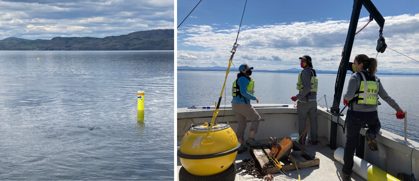
The modeling system also used data from a buoy that provided wave conditions from the lake for model validation. Wave conditions are critical to public safety both for recreational and commercial activities on the lake – such as for boats, harbors, and beaches – but also for predicting coastal flood impacts at the shoreline where waves can run up and significantly impact infrastructure. Before the study deployed this wave buoy, no wave observations were available to describe conditions in Lake Champlain.
Left: NOAA buoy in Lake Champlain. Credit: University of Vermont FEMC staff. Right: NOAA GLERL’s partners at the University of Vermont’s Forest Ecosystem Monitoring Cooperative (FEMC) deployed the buoy on Lake Champlain in May 2021. Credit: University of Vermont FEMC staff.
This experimental forecasting system, which began running in 2022, now informs National Weather Service flood forecasts for the Lake Champlain-Richelieu River system and provides information for inundation mapping, recreational boating, and search and rescue efforts.
Improved flood mitigation for the future
In February 2023, after many years of dedicated work, the LCRR Study Board submitted its recommendations to the U.S. and Canadian governments about the reduction of risks and potential solutions to flooding in the Lake Champlain-Richelieu River basin. The recommendations follow four key themes:
Reduce high water levels on the Richelieu River and Lake Champlain.
Impede inflows into Lake Champlain or the Richelieu River through wetland and temporary upstream storage of floodwaters.
Improve flood response (flood forecasting and emergency preparedness).
Enhance floodplain management (adaptation to flooding).
NOAA GLERL and CIGLR’s work creating the Experimental Lake Champlain Forecast System will undoubtedly lead to better forecasting and safer conditions in the LCRR basin for years to come.
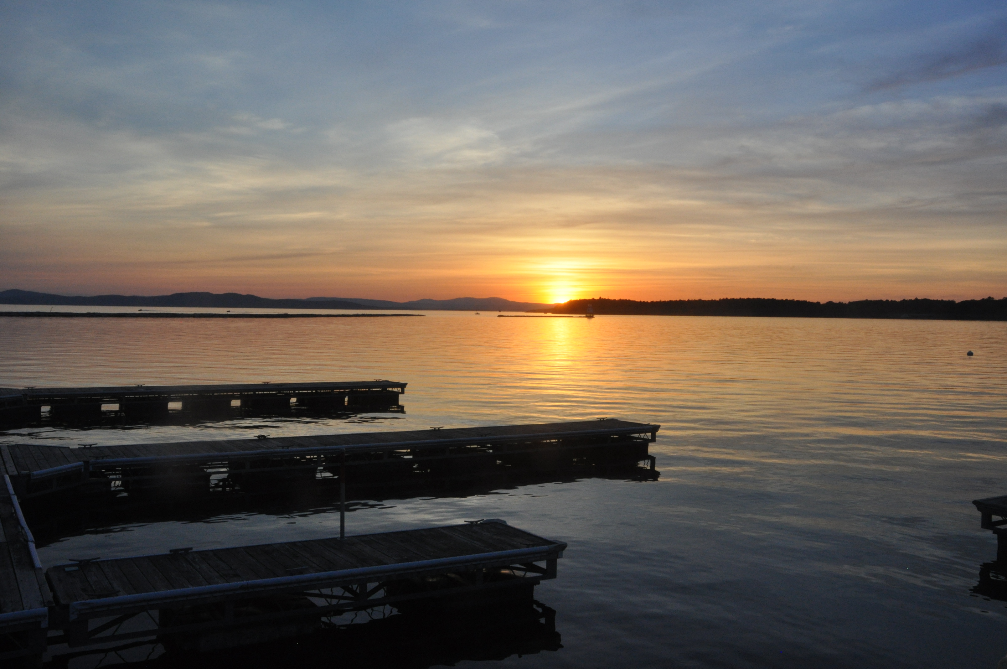
Sunset on Lake Champlain. Credit: Dan Titze, NOAA GLERL.
Partners on NOAA GLERL’s portion of this project include:
International Joint Commission Lake Champlain-Richelieu River Study Board
Cooperative Institute for Great Lakes Research
University of Vermont Forest Ecosystem Monitoring Cooperative
University of San Diego Scripps Institute of Oceanography Coastal Data Information Program
National Center for Atmospheric Research
NOAA Offices:
Northeast River Forecast Center
Weather Forecast Office Burlington, VT
Office of Coast Survey Coast Survey Development Laboratory
National Centers for Environmental Prediction Environmental Modeling Center


